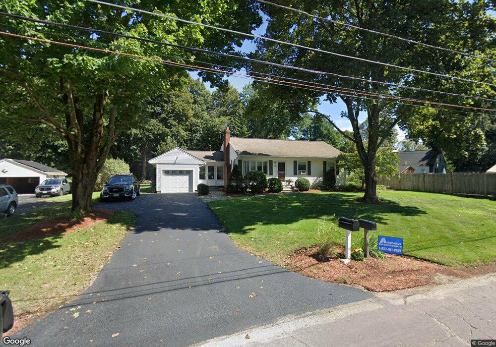
20 Woodland Rd Wrentham, MA 02093
Estimated Value: $534,000 - $557,000
3
Beds
2
Baths
1,026
Sq Ft
$528/Sq Ft
Est. Value
About This Home
This home is located at 20 Woodland Rd, Wrentham, MA 02093 and is currently estimated at $541,838, approximately $528 per square foot. 20 Woodland Rd is a home located in Norfolk County with nearby schools including Delaney Elementary School, Charles E Roderick, and Foxborough Regional Charter School.
Ownership History
Date
Name
Owned For
Owner Type
Purchase Details
Closed on
Mar 18, 2024
Sold by
Legere Jason T and Legere Karen M
Bought by
Legere Ft and Legere
Current Estimated Value
Purchase Details
Closed on
Nov 14, 2011
Sold by
Legere Karen
Bought by
Legere Karen and Legere Jason T
Home Financials for this Owner
Home Financials are based on the most recent Mortgage that was taken out on this home.
Original Mortgage
$206,000
Interest Rate
4.01%
Mortgage Type
Purchase Money Mortgage
Purchase Details
Closed on
Aug 23, 2002
Sold by
Morrill Kathleen A
Bought by
Legere Karen
Home Financials for this Owner
Home Financials are based on the most recent Mortgage that was taken out on this home.
Original Mortgage
$234,000
Interest Rate
6.57%
Mortgage Type
Purchase Money Mortgage
Create a Home Valuation Report for This Property
The Home Valuation Report is an in-depth analysis detailing your home's value as well as a comparison with similar homes in the area
Home Values in the Area
Average Home Value in this Area
Purchase History
| Date | Buyer | Sale Price | Title Company |
|---|---|---|---|
| Legere Ft | -- | None Available | |
| Legere Karen | -- | -- | |
| Legere Karen | $260,000 | -- |
Source: Public Records
Mortgage History
| Date | Status | Borrower | Loan Amount |
|---|---|---|---|
| Previous Owner | Legere Karen | $206,000 | |
| Previous Owner | Legere Karen | $234,000 |
Source: Public Records
Tax History Compared to Growth
Tax History
| Year | Tax Paid | Tax Assessment Tax Assessment Total Assessment is a certain percentage of the fair market value that is determined by local assessors to be the total taxable value of land and additions on the property. | Land | Improvement |
|---|---|---|---|---|
| 2025 | $5,734 | $494,700 | $271,200 | $223,500 |
| 2024 | $5,357 | $446,400 | $271,200 | $175,200 |
| 2023 | $5,088 | $403,200 | $246,600 | $156,600 |
| 2022 | $5,114 | $374,100 | $230,000 | $144,100 |
| 2021 | $4,757 | $338,100 | $200,800 | $137,300 |
| 2020 | $4,484 | $314,700 | $178,500 | $136,200 |
| 2019 | $4,247 | $300,800 | $178,500 | $122,300 |
| 2018 | $4,295 | $301,600 | $178,600 | $123,000 |
| 2017 | $4,066 | $285,300 | $175,200 | $110,100 |
| 2016 | $3,971 | $278,100 | $170,100 | $108,000 |
| 2015 | $3,835 | $256,000 | $163,500 | $92,500 |
| 2014 | $3,570 | $233,200 | $144,200 | $89,000 |
Source: Public Records
Map
Nearby Homes
- 362 East St
- 155 Clark Rd Unit 155
- 1 Lorraine Metcalf Dr
- 270 Dedham St
- 65 Pond St
- 10 Nature View Dr
- 15 Nature View Dr
- 319 Taunton St
- 120 Hawes St
- 483 Thurston St
- 25 Foxboro Rd
- 131 Creek St Unit 7
- 11 Earle Stewart Ln
- 131 Washington St Unit 42
- Lot 3 - 14 Earle Stewart Ln
- Lot 1 - Blueberry 2 Car Plan at King Philip Estates
- Lot 8 - Blueberry 2 Car Plan at King Philip Estates
- Lot 5 - Hughes 2 car Plan at King Philip Estates
- Lot 6 - Blueberry 3 Car Plan at King Philip Estates
- Lot 2 - Camden 2 Car Plan at King Philip Estates
- 21 Woodland Rd
- 28 Woodland Rd
- 27 Woodland Rd
- 33 Woodland Rd
- 36 Woodland Rd
- 387 East St
- 361 East St
- 361 East St Unit B
- 361 East St
- 361 East St Unit 1
- 361 East St Unit 2
- 361 East St Unit A
- 365 East St
- 391 East St
- 39 Woodland Rd
- 357 East St
- 10 King James Way
- 353 East St Unit 4
- 353 East St Unit 2
- 353 East St