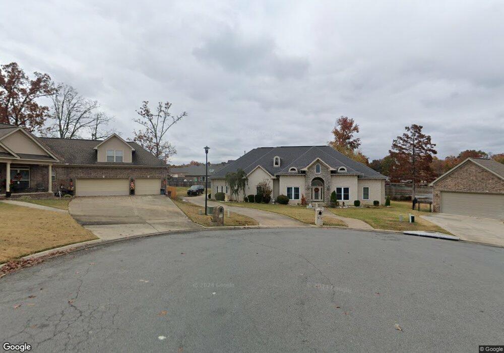
2001 Madison Layne Ct Sherwood, AR 72120
Estimated Value: $450,122 - $505,000
--
Bed
4
Baths
3,452
Sq Ft
$138/Sq Ft
Est. Value
About This Home
This home is located at 2001 Madison Layne Ct, Sherwood, AR 72120 and is currently estimated at $477,531, approximately $138 per square foot. 2001 Madison Layne Ct is a home located in Pulaski County with nearby schools including Clinton Elementary School, Sylvan Hills Middle School, and Sylvan Hills High School.
Ownership History
Date
Name
Owned For
Owner Type
Purchase Details
Closed on
Aug 2, 2007
Sold by
Clyburn Lindsey and Clyburn Chai
Bought by
Miller Hayse
Current Estimated Value
Home Financials for this Owner
Home Financials are based on the most recent Mortgage that was taken out on this home.
Original Mortgage
$329,400
Outstanding Balance
$207,920
Interest Rate
6.69%
Mortgage Type
Purchase Money Mortgage
Estimated Equity
$269,611
Purchase Details
Closed on
Jun 13, 2006
Sold by
Randy Wiggins Development Co Inc
Bought by
Clyburn Lindsey and Backers Josef
Home Financials for this Owner
Home Financials are based on the most recent Mortgage that was taken out on this home.
Original Mortgage
$290,000
Interest Rate
6.6%
Mortgage Type
Purchase Money Mortgage
Create a Home Valuation Report for This Property
The Home Valuation Report is an in-depth analysis detailing your home's value as well as a comparison with similar homes in the area
Home Values in the Area
Average Home Value in this Area
Purchase History
| Date | Buyer | Sale Price | Title Company |
|---|---|---|---|
| Miller Hayse | $366,000 | Multiple | |
| Clyburn Lindsey | $50,000 | American Abstract & Title Co |
Source: Public Records
Mortgage History
| Date | Status | Borrower | Loan Amount |
|---|---|---|---|
| Open | Miller Hayse | $329,400 | |
| Previous Owner | Clyburn Lindsey | $290,000 |
Source: Public Records
Tax History Compared to Growth
Tax History
| Year | Tax Paid | Tax Assessment Tax Assessment Total Assessment is a certain percentage of the fair market value that is determined by local assessors to be the total taxable value of land and additions on the property. | Land | Improvement |
|---|---|---|---|---|
| 2025 | $3,006 | $76,886 | $10,400 | $66,486 |
| 2024 | $3,306 | $76,886 | $10,400 | $66,486 |
| 2023 | $3,306 | $76,886 | $10,400 | $66,486 |
| 2022 | $3,531 | $76,886 | $10,400 | $66,486 |
| 2021 | $3,288 | $57,700 | $6,000 | $51,700 |
| 2020 | $2,913 | $57,700 | $6,000 | $51,700 |
| 2019 | $2,913 | $57,700 | $6,000 | $51,700 |
| 2018 | $2,938 | $57,700 | $6,000 | $51,700 |
| 2017 | $2,938 | $57,700 | $6,000 | $51,700 |
| 2016 | $3,422 | $65,680 | $10,800 | $54,880 |
| 2015 | $3,337 | $65,680 | $10,800 | $54,880 |
| 2014 | $3,337 | $65,680 | $10,800 | $54,880 |
Source: Public Records
Map
Nearby Homes
- 2125 Glenn Arbor Ct
- 7416 Glenn Hills Dr
- 68 Shoshoni Dr
- 6813 Gap Point Cir
- 2125 Gap Creek Dr
- 10 Ponca St
- 6901 Gap Point Cir
- 7000 Park Meadows Dr
- 606 Bay View Ct
- 2226 Bearskin Dr
- 7112 E Ridge Dr
- 1306 Tupelo Ct
- 106 Winona Dr
- 2216 Sage Meadows Cir
- 201 Bearskin Dr
- 1013 Black Bass Cove
- 7204 Northlake Dr
- 109 Bucky Beaver St
- 7000 Northlake Dr
- 112 Sugar Maple Dr
- 2009 Madison Layne Ct
- 2000 Madison Layne Ct
- 7009 Kailee Ladema Ct
- 2017 Madison Layne Ct
- 0 Madison Layne Ct Unit 17010377
- 2116 Glenn Arbor Ct
- 2124 Glenn Arbor Ct
- 7017 Kailee Ladema Ct
- 2108 Glenn Arbor Ct
- 2132 Glenn Arbor Ct
- 0 Glenn Arbor Ct Unit 15031563
- 0 Glenn Arbor Ct Unit 16000576
- 0 Glenn Arbor Ct Unit 17021716
- 0 Glenn Arbor Ct Unit 20028544
- 2140 Glenn Arbor Ct
- 2025 Madison Layne Ct
- 2100 Glenn Arbor Ct
- 2016 Madison Layne Ct
- 7016 Kailee Ladema Ct
- 2148 Glenn Arbor Ct