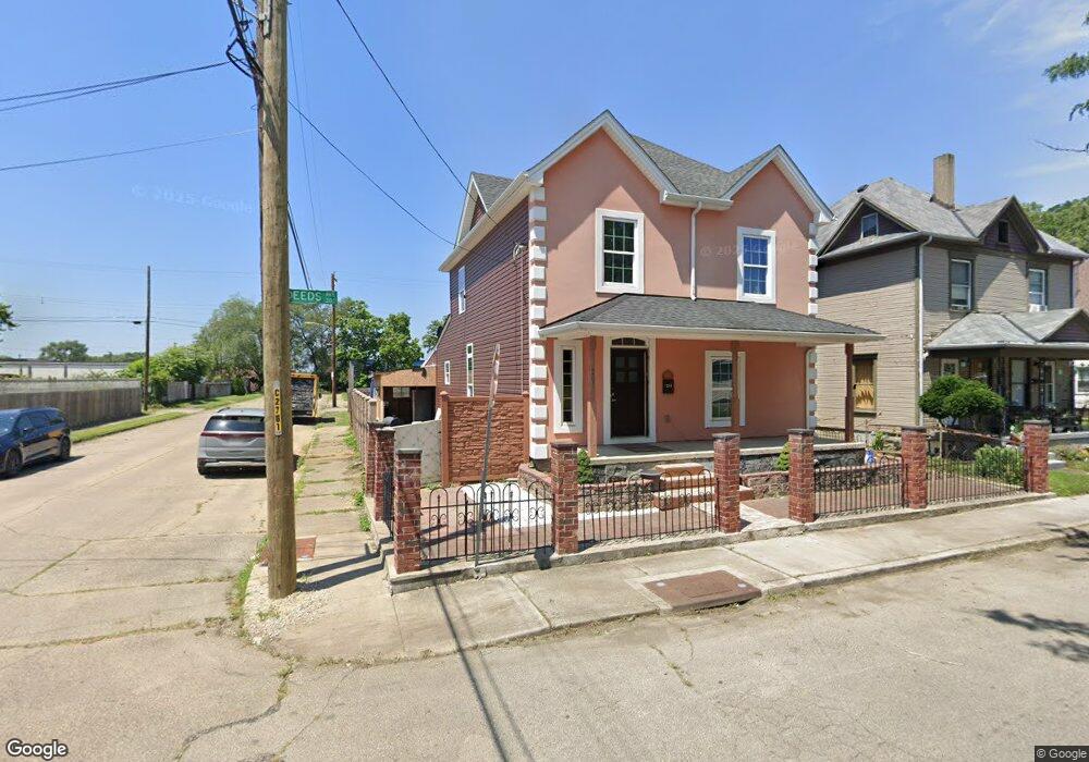
201 Deeds Ave Dayton, OH 45404
Old North Dayton NeighborhoodEstimated Value: $130,235 - $219,000
4
Beds
2
Baths
2,528
Sq Ft
$72/Sq Ft
Est. Value
About This Home
This home is located at 201 Deeds Ave, Dayton, OH 45404 and is currently estimated at $181,809, approximately $71 per square foot. 201 Deeds Ave is a home located in Montgomery County with nearby schools including Kiser Elementary, Ruskin Elementary School, and Liberty High School.
Ownership History
Date
Name
Owned For
Owner Type
Purchase Details
Closed on
May 16, 2012
Sold by
Mclerran Tommy K and Mclerran Julie A
Bought by
Yuqui Jorge
Current Estimated Value
Purchase Details
Closed on
Sep 6, 2000
Sold by
Davis Wilma and Davis Wilma C
Bought by
Mclerran Tommy K and Mclerran Julie A
Purchase Details
Closed on
May 4, 1995
Sold by
Mckenzie Florence L and Haller Florance L
Bought by
Davis Wilma and Davis Wilma C
Create a Home Valuation Report for This Property
The Home Valuation Report is an in-depth analysis detailing your home's value as well as a comparison with similar homes in the area
Home Values in the Area
Average Home Value in this Area
Purchase History
| Date | Buyer | Sale Price | Title Company |
|---|---|---|---|
| Yuqui Jorge | $8,000 | None Available | |
| Mclerran Tommy K | $34,000 | -- | |
| Davis Wilma | -- | -- |
Source: Public Records
Tax History Compared to Growth
Tax History
| Year | Tax Paid | Tax Assessment Tax Assessment Total Assessment is a certain percentage of the fair market value that is determined by local assessors to be the total taxable value of land and additions on the property. | Land | Improvement |
|---|---|---|---|---|
| 2024 | $1,893 | $32,170 | $2,030 | $30,140 |
| 2023 | $1,893 | $32,170 | $2,030 | $30,140 |
| 2022 | $2,073 | $27,390 | $1,730 | $25,660 |
| 2021 | $1,730 | $22,730 | $1,730 | $21,000 |
| 2020 | $1,727 | $22,730 | $1,730 | $21,000 |
| 2019 | $1,723 | $20,550 | $1,460 | $19,090 |
| 2018 | $1,725 | $20,550 | $1,460 | $19,090 |
| 2017 | $1,164 | $13,190 | $1,460 | $11,730 |
| 2016 | $455 | $4,050 | $1,390 | $2,660 |
| 2015 | $938 | $3,050 | $1,390 | $1,660 |
| 2014 | $938 | $3,050 | $1,390 | $1,660 |
| 2012 | -- | $12,960 | $3,150 | $9,810 |
Source: Public Records
Map
Nearby Homes
- 426 Troy St
- 414 Hart St Unit 412
- 726 Taylor St Unit 128
- 718 Taylor St
- 719 N Keowee St
- 739 N Keowee St
- 139 Grove Ave
- 147 Grove Ave
- 1531 Chapel St
- 151 Grove Ave
- 534 Maryland Ave
- 729 Troy St
- 730 Troy St
- 82 Notre Dame Ave
- 36 Baltimore St
- 96 Notre Dame Ave
- 70 Baltimore St
- 159 Alton Ave Unit 157
- 144 Alton Ave
- 260 Grove Ave