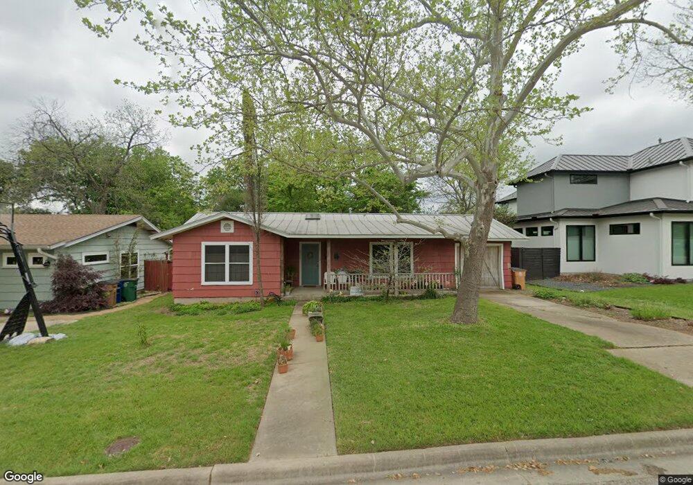
2017 Brentwood St Austin, TX 78757
Brentwood NeighborhoodEstimated Value: $571,037 - $811,000
--
Bed
1
Bath
1,241
Sq Ft
$520/Sq Ft
Est. Value
About This Home
This home is located at 2017 Brentwood St, Austin, TX 78757 and is currently estimated at $644,759, approximately $519 per square foot. 2017 Brentwood St is a home located in Travis County with nearby schools including Brentwood Elementary School, Lamar Middle School, and McCallum High School.
Ownership History
Date
Name
Owned For
Owner Type
Purchase Details
Closed on
Aug 18, 1998
Sold by
Olson Dora Pauline and Stokes Bendella A
Bought by
Petersen Susan C
Current Estimated Value
Home Financials for this Owner
Home Financials are based on the most recent Mortgage that was taken out on this home.
Original Mortgage
$66,900
Outstanding Balance
$13,932
Interest Rate
6.9%
Mortgage Type
Purchase Money Mortgage
Estimated Equity
$630,827
Purchase Details
Closed on
Feb 23, 1995
Sold by
Petersen Dorothy L
Bought by
Petersen Arthur L
Create a Home Valuation Report for This Property
The Home Valuation Report is an in-depth analysis detailing your home's value as well as a comparison with similar homes in the area
Home Values in the Area
Average Home Value in this Area
Purchase History
| Date | Buyer | Sale Price | Title Company |
|---|---|---|---|
| Petersen Susan C | -- | Texas Professional Title Inc | |
| Petersen Arthur L | -- | -- |
Source: Public Records
Mortgage History
| Date | Status | Borrower | Loan Amount |
|---|---|---|---|
| Open | Petersen Susan C | $66,900 |
Source: Public Records
Tax History Compared to Growth
Tax History
| Year | Tax Paid | Tax Assessment Tax Assessment Total Assessment is a certain percentage of the fair market value that is determined by local assessors to be the total taxable value of land and additions on the property. | Land | Improvement |
|---|---|---|---|---|
| 2025 | $5,333 | $556,506 | $362,516 | $193,990 |
| 2023 | $5,087 | $548,811 | $0 | $0 |
| 2022 | $9,853 | $498,919 | $0 | $0 |
| 2021 | $9,873 | $453,563 | $300,000 | $153,563 |
| 2020 | $8,921 | $415,918 | $300,000 | $115,918 |
| 2018 | $8,541 | $385,789 | $300,000 | $85,789 |
| 2017 | $7,887 | $353,636 | $250,000 | $103,636 |
| 2016 | $7,287 | $326,759 | $250,000 | $102,281 |
| 2015 | $5,924 | $297,054 | $210,000 | $113,007 |
| 2014 | $5,924 | $270,049 | $0 | $0 |
Source: Public Records
Map
Nearby Homes
- 2019 Brentwood St
- 6602 Laird Dr
- 1900 Burbank St
- 1812 Burbank St
- 2009 Payne Ave Unit 2
- 2004 Pequeno St
- 6444 Burnet Rd Unit 204
- 6444 Burnet Rd Unit 305
- 1907 Payne Ave
- 1711 Brentwood St
- 1708 Payne Ave
- 1912 Romeria Dr Unit B
- 1701 Brentwood St
- 1915 Cullen Ave
- 6210 Camino Real
- 1701 Alcove Ct
- 1513 Ruth Ave
- 2601 Park View Dr
- 2012 Cullen Ave
- 6403 Nasco Dr
- 2015 Brentwood St
- 6517 Laird Dr
- 2013 Brentwood St
- 2016 Brentwood St
- 2014 Karen Ave
- 2014 Karen Ave Unit B
- 2018 Brentwood St
- 2014 Brentwood St
- 2011 Brentwood St
- 2016 Karen Ave
- 2012 Karen Ave
- 6518 Laird Dr
- 6520 Laird Dr
- 2012 Brentwood St
- 6522 Laird Dr
- 6516 Laird Dr
- 6509 Laird Dr
- 2010 Karen Ave
- 6600 Laird Dr
- 2009 Brentwood St