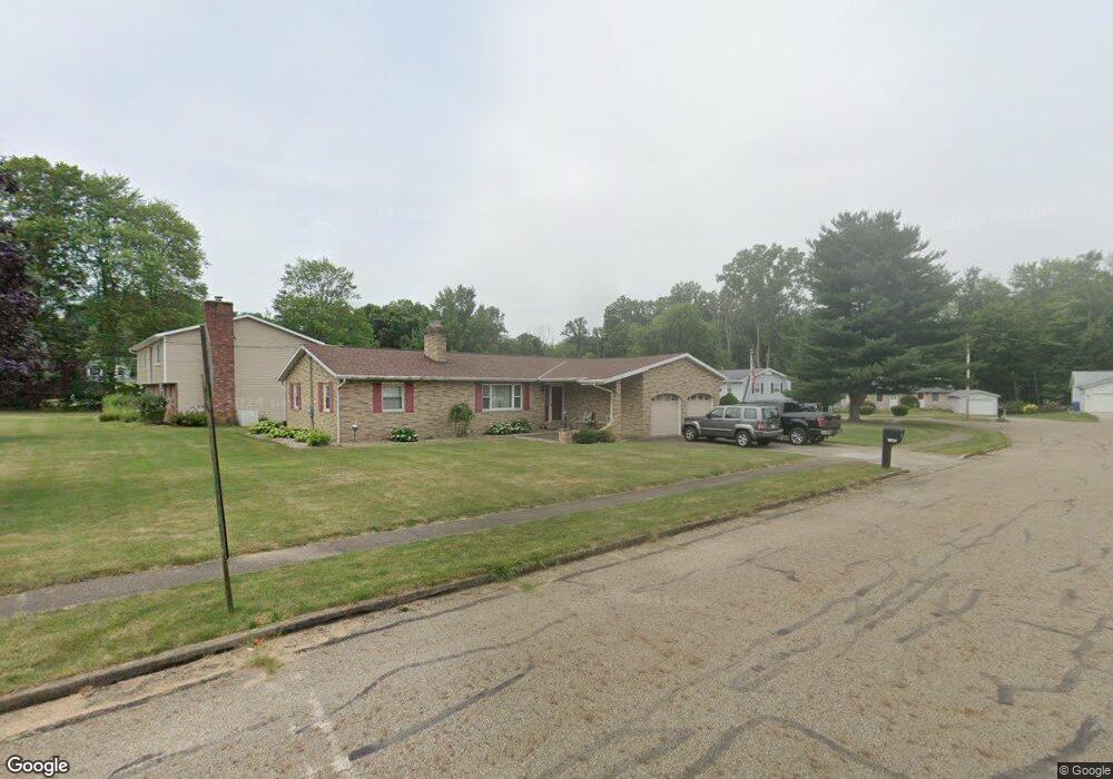
2020 Ashbrook Ave Louisville, OH 44641
Estimated Value: $205,901 - $259,000
3
Beds
1
Bath
1,320
Sq Ft
$180/Sq Ft
Est. Value
About This Home
This home is located at 2020 Ashbrook Ave, Louisville, OH 44641 and is currently estimated at $236,975, approximately $179 per square foot. 2020 Ashbrook Ave is a home located in Stark County with nearby schools including Louisville High School and St. Thomas Aquinas High School & Middle School.
Ownership History
Date
Name
Owned For
Owner Type
Purchase Details
Closed on
Mar 13, 1997
Sold by
Dorothy A Mantz Trst
Bought by
Miller James P and Miller Sandra
Current Estimated Value
Home Financials for this Owner
Home Financials are based on the most recent Mortgage that was taken out on this home.
Original Mortgage
$40,000
Interest Rate
7.95%
Mortgage Type
New Conventional
Create a Home Valuation Report for This Property
The Home Valuation Report is an in-depth analysis detailing your home's value as well as a comparison with similar homes in the area
Home Values in the Area
Average Home Value in this Area
Purchase History
| Date | Buyer | Sale Price | Title Company |
|---|---|---|---|
| Miller James P | $88,000 | -- |
Source: Public Records
Mortgage History
| Date | Status | Borrower | Loan Amount |
|---|---|---|---|
| Closed | Miller James P | $40,000 |
Source: Public Records
Tax History Compared to Growth
Tax History
| Year | Tax Paid | Tax Assessment Tax Assessment Total Assessment is a certain percentage of the fair market value that is determined by local assessors to be the total taxable value of land and additions on the property. | Land | Improvement |
|---|---|---|---|---|
| 2025 | -- | $57,610 | $15,890 | $41,720 |
| 2024 | -- | $57,610 | $15,890 | $41,720 |
| 2023 | $1,907 | $53,520 | $15,020 | $38,500 |
| 2022 | $1,931 | $53,520 | $15,020 | $38,500 |
| 2021 | $1,936 | $53,520 | $15,020 | $38,500 |
| 2020 | $1,538 | $47,360 | $13,510 | $33,850 |
| 2019 | $1,544 | $45,720 | $11,870 | $33,850 |
| 2018 | $1,473 | $45,720 | $11,870 | $33,850 |
| 2017 | $1,323 | $40,780 | $10,400 | $30,380 |
| 2016 | $1,350 | $40,780 | $10,400 | $30,380 |
| 2015 | $1,354 | $40,780 | $10,400 | $30,380 |
| 2014 | $1,207 | $35,290 | $9,000 | $26,290 |
| 2013 | $607 | $35,290 | $9,000 | $26,290 |
Source: Public Records
Map
Nearby Homes
- 1812 E Broad St
- 1715 High St
- 2015 E Main St
- 2110 Edmar St
- 0 Michigan Blvd
- 641 S Nickelplate St
- 308 Superior St
- 520 S Silver St
- 728 E Broad St
- 3390 Meese Rd NE
- 1170 Winding Ridge Ave
- 325 Lincoln Ave
- 908 Sand Lot Cir
- 204 E Broad St
- 510 S Bauman Ct
- 107 E Broad St
- 910 Crosswyck Cir
- 5495 Meese Rd NE
- 428 Honeycrisp Dr NE
- 3047 Mcintosh Dr NE
- 513 Brookfield St
- 2002 Ashbrook Ave
- 2000 Ashbrook Ave
- 425 Brookfield St
- 510 Brookfield St
- 2007 Ashbrook Ave
- 422 Brookfield St
- 523 Brookfield Cir
- 421 Brookfield St
- 2114 Ashbrook Ave
- 418 Brookfield St
- 524 Brookfield Cir
- 2109 Ashbrook Ave
- 527 Brookfield Cir
- 2115 Ashbrook Ave
- 2115 Ashbrook St
- 2134 Ashbrook Ave
- 2121 Ashbrook Ave
- 528 Brookfield Cir
- 531 Brookfield Cir