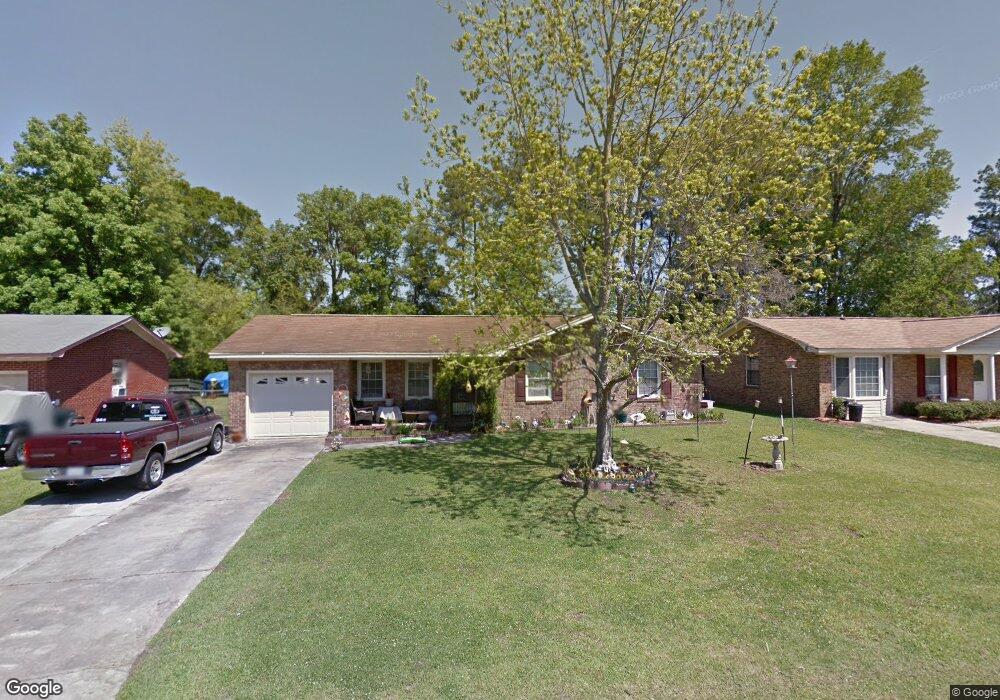
203 Judith Dr Summerville, SC 29485
Estimated Value: $242,000 - $311,000
3
Beds
2
Baths
1,445
Sq Ft
$186/Sq Ft
Est. Value
About This Home
This home is located at 203 Judith Dr, Summerville, SC 29485 and is currently estimated at $268,180, approximately $185 per square foot. 203 Judith Dr is a home located in Dorchester County with nearby schools including Dr. Eugene Sires Elementary, Alston Middle School, and Ashley Ridge High School.
Ownership History
Date
Name
Owned For
Owner Type
Purchase Details
Closed on
May 25, 2012
Sold by
Ulmer Robert C and Ulmer Kevin F
Bought by
Beasley Brenda S
Current Estimated Value
Home Financials for this Owner
Home Financials are based on the most recent Mortgage that was taken out on this home.
Original Mortgage
$80,800
Outstanding Balance
$55,704
Interest Rate
3.87%
Mortgage Type
FHA
Estimated Equity
$212,476
Purchase Details
Closed on
Dec 16, 2011
Sold by
Estate Of Robert Willard Ulmer and Ulmer Robert C
Bought by
Ulmer Robert C and Ulmer Kevin F
Create a Home Valuation Report for This Property
The Home Valuation Report is an in-depth analysis detailing your home's value as well as a comparison with similar homes in the area
Home Values in the Area
Average Home Value in this Area
Purchase History
| Date | Buyer | Sale Price | Title Company |
|---|---|---|---|
| Beasley Brenda S | $100,000 | -- | |
| Ulmer Robert C | -- | -- |
Source: Public Records
Mortgage History
| Date | Status | Borrower | Loan Amount |
|---|---|---|---|
| Open | Beasley Brenda S | $80,800 |
Source: Public Records
Tax History Compared to Growth
Tax History
| Year | Tax Paid | Tax Assessment Tax Assessment Total Assessment is a certain percentage of the fair market value that is determined by local assessors to be the total taxable value of land and additions on the property. | Land | Improvement |
|---|---|---|---|---|
| 2025 | $738 | $8,490 | $2,400 | $6,090 |
| 2024 | $738 | $8,490 | $2,400 | $6,090 |
| 2023 | $738 | $6,624 | $960 | $5,664 |
| 2022 | $624 | $4,850 | $1,100 | $3,750 |
| 2021 | $624 | $4,850 | $1,100 | $3,750 |
| 2020 | $560 | $4,220 | $960 | $3,260 |
| 2019 | $544 | $4,220 | $960 | $3,260 |
| 2018 | $448 | $4,220 | $960 | $3,260 |
| 2017 | $445 | $4,220 | $960 | $3,260 |
| 2016 | $436 | $4,220 | $960 | $3,260 |
| 2015 | $434 | $4,220 | $960 | $3,260 |
| 2014 | $685 | $99,800 | $0 | $0 |
| 2013 | -- | $5,990 | $0 | $0 |
Source: Public Records
Map
Nearby Homes
- 123 Lynches River Dr
- 136 Lynches River Dr
- 106 Black River Dr
- 212 Congaree River Dr
- 230 Congaree River Dr
- 216 Congaree River Dr
- 111 Broad River Dr
- 217 Seneca River Dr
- 103 Savannah River Dr
- 191 Brittondale Rd
- 1004 Miles Jamison Rd
- 109 Greenhurst Ave
- 206 Terry Ave
- 103 Peake Ln
- 9622 Stockport Cir
- 161 Keaton Brook Dr
- 170 Keaton Brook Dr
- 9692 Stockport Cir
- 9717 Stockport Cir
- 3375 Middlesboro Ave
- 205 Judith Dr
- 163 Black River Dr
- 207 Judith Dr
- 100 Catherine St
- 161 Black River Dr
- 165 Black River Dr
- 159 Black River Dr
- 200 Judith Dr
- 167 Black River Dr
- 202 Judith Dr
- 157 Black River Dr
- 166 Black River Dr
- 209 Judith Dr
- 155 Black River Dr
- 204 Judith Dr
- 102 Catherine St
- 153 Black River Dr
- 125 Saint Catherines Ct
- 116 Saint Catherines Ct
- 126 Saint Catherines Ct