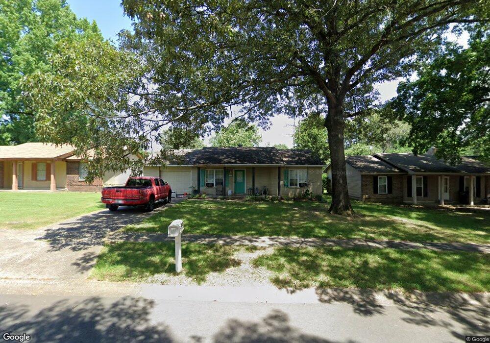
203 Lonsdale Cir Jacksonville, AR 72076
Estimated Value: $109,000 - $135,000
--
Bed
3
Baths
1,200
Sq Ft
$103/Sq Ft
Est. Value
About This Home
This home is located at 203 Lonsdale Cir, Jacksonville, AR 72076 and is currently estimated at $123,244, approximately $102 per square foot. 203 Lonsdale Cir is a home located in Pulaski County with nearby schools including Murrell Taylor Elementary School, Jacksonville Middle School, and Jacksonville High School.
Ownership History
Date
Name
Owned For
Owner Type
Purchase Details
Closed on
Jan 27, 2009
Sold by
Copestone Investments Inc and Merced Jonathan
Bought by
Butler Christopher
Current Estimated Value
Home Financials for this Owner
Home Financials are based on the most recent Mortgage that was taken out on this home.
Original Mortgage
$88,257
Outstanding Balance
$55,637
Interest Rate
5.13%
Mortgage Type
VA
Estimated Equity
$67,607
Purchase Details
Closed on
Jun 9, 2008
Sold by
Northern Samuel B and Northern Wanda J
Bought by
Copestone Investments Inc and Merced Jonathan
Create a Home Valuation Report for This Property
The Home Valuation Report is an in-depth analysis detailing your home's value as well as a comparison with similar homes in the area
Home Values in the Area
Average Home Value in this Area
Purchase History
| Date | Buyer | Sale Price | Title Company |
|---|---|---|---|
| Butler Christopher | -- | United Abstract & Title Co | |
| Copestone Investments Inc | $29,000 | United Abstract & Title Co |
Source: Public Records
Mortgage History
| Date | Status | Borrower | Loan Amount |
|---|---|---|---|
| Open | Butler Christopher | $88,257 |
Source: Public Records
Tax History Compared to Growth
Tax History
| Year | Tax Paid | Tax Assessment Tax Assessment Total Assessment is a certain percentage of the fair market value that is determined by local assessors to be the total taxable value of land and additions on the property. | Land | Improvement |
|---|---|---|---|---|
| 2025 | $1,090 | $18,322 | $1,200 | $17,122 |
| 2024 | $818 | $18,322 | $1,200 | $17,122 |
| 2023 | $818 | $18,322 | $1,200 | $17,122 |
| 2022 | $856 | $18,322 | $1,200 | $17,122 |
| 2021 | $778 | $12,670 | $1,600 | $11,070 |
| 2020 | $778 | $12,670 | $1,600 | $11,070 |
| 2019 | $778 | $12,670 | $1,600 | $11,070 |
| 2018 | $778 | $12,670 | $1,600 | $11,070 |
| 2017 | $778 | $12,670 | $1,600 | $11,070 |
| 2016 | $809 | $15,030 | $2,400 | $12,630 |
| 2015 | $809 | $15,030 | $2,400 | $12,630 |
| 2014 | $809 | $15,030 | $2,400 | $12,630 |
Source: Public Records
Map
Nearby Homes
- 1404 Southeastern Ave
- 219 Lonsdale Cir
- 13 Michelle Ln Unit A
- 2003 Old Military Rd
- 2209 Old Military Rd
- 720 Southeastern Ave
- 1302 King St
- 600 Sorrells Dr
- 1401 Tamara Park
- 1305 Glenn Rd
- 910 Ray Rd
- 0 S J P Wright Loop Rd
- 419 Church St
- 32 Ross Cir
- 26 Wright Cir
- 1110 Wright St
- 602 Ray Rd
- 134 Pike Ave
- 29 Collins Rd
- 10 Park Dr
- 201 Lonsdale Cir
- 205 Lonsdale Cir
- 117 Briarfield Cove
- 207 Lonsdale Cir
- 200 Lonsdale Cir
- 202 Lonsdale Cir
- 116 Briarfield Cove
- 134 Lonsdale Cir
- 115 Briarfield Cove
- 131 Lonsdale Cir
- 132 Lonsdale Cir
- 206 Lonsdale Cir
- 217 Lonsdale Cir
- 114 Briarfield Cove
- 1400 Southeastern Ave
- 1402 Southeastern Ave
- 113 Briarfield Cove
- 130 Lonsdale Cir
- 208 Lonsdale Cir
- 1322 Southeastern Ave