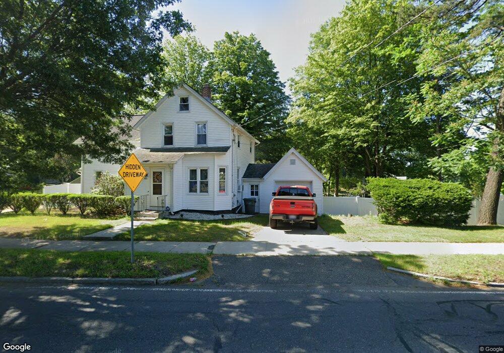
2035 Page Blvd Indian Orchard, MA 01151
Indian Orchard NeighborhoodEstimated Value: $179,000 - $259,000
2
Beds
1
Bath
856
Sq Ft
$250/Sq Ft
Est. Value
About This Home
This home is located at 2035 Page Blvd, Indian Orchard, MA 01151 and is currently estimated at $214,086, approximately $250 per square foot. 2035 Page Blvd is a home located in Hampden County with nearby schools including Warner, John F. Kennedy Academy, and Roger L. Putnam Vocational Technical Academy.
Ownership History
Date
Name
Owned For
Owner Type
Purchase Details
Closed on
Jul 12, 2017
Sold by
Lake Lorraine Llc
Bought by
Rrjj Page Boulevard Rt
Current Estimated Value
Purchase Details
Closed on
Mar 7, 1995
Sold by
Gebo Vivian L
Bought by
Kenniston Ronald E
Home Financials for this Owner
Home Financials are based on the most recent Mortgage that was taken out on this home.
Original Mortgage
$66,750
Interest Rate
8.96%
Mortgage Type
Purchase Money Mortgage
Create a Home Valuation Report for This Property
The Home Valuation Report is an in-depth analysis detailing your home's value as well as a comparison with similar homes in the area
Home Values in the Area
Average Home Value in this Area
Purchase History
| Date | Buyer | Sale Price | Title Company |
|---|---|---|---|
| Rrjj Page Boulevard Rt | -- | -- | |
| Kenniston Ronald E | $65,000 | -- |
Source: Public Records
Mortgage History
| Date | Status | Borrower | Loan Amount |
|---|---|---|---|
| Previous Owner | Kenniston Ronald E | $66,750 |
Source: Public Records
Tax History Compared to Growth
Tax History
| Year | Tax Paid | Tax Assessment Tax Assessment Total Assessment is a certain percentage of the fair market value that is determined by local assessors to be the total taxable value of land and additions on the property. | Land | Improvement |
|---|---|---|---|---|
| 2025 | $2,244 | $143,100 | $39,500 | $103,600 |
| 2024 | $2,139 | $133,200 | $37,000 | $96,200 |
| 2023 | $2,155 | $126,400 | $30,300 | $96,100 |
| 2022 | $1,993 | $105,900 | $28,300 | $77,600 |
| 2021 | $1,813 | $95,900 | $25,800 | $70,100 |
| 2020 | $1,857 | $95,100 | $25,800 | $69,300 |
| 2019 | $1,679 | $85,300 | $26,700 | $58,600 |
| 2018 | $1,592 | $80,900 | $26,700 | $54,200 |
| 2017 | $1,543 | $78,500 | $22,700 | $55,800 |
| 2016 | $1,653 | $84,100 | $22,700 | $61,400 |
| 2015 | $1,591 | $80,900 | $22,700 | $58,200 |
Source: Public Records
Map
Nearby Homes
- 140 Cardinal St
- 0 Michon St
- 49 Mohegan Ave
- 37 Champlain Ave
- 98 Pine Grove St
- 97-99 Pine Grove St
- 89 Pine Grove St
- 31 Wing St
- 42 Geneva St
- 34 Temby St
- 189 Essex St Unit H
- 108 Barre St
- 61 Glenmore St
- 1200 Worcester St
- 70 Shumway St Unit 29
- 70 Shumway St Unit A1
- 130 Mazarin St
- 501 Oak St
- 39 Wallace St
- 34 Wallace St
- 2025 Page Blvd
- 2039 Page Blvd
- 2031 Page Blvd
- 2015 Page Blvd
- 2047 Page Blvd
- 2057 Page Blvd
- 2036 Page Blvd Unit 2038
- 2042 Page Blvd Unit 2044
- 2059 Page Blvd
- 2046 Page Blvd Unit 2048
- 1987 Page Blvd
- 14 Battery St Unit 16
- 14-16 Battery St
- 2060 Page Blvd Unit 2062
- 2060-2062 Page Blvd
- 2075 Page Blvd
- 2071 Page Blvd
- 20 Battery St
- 2066 Page Blvd Unit 2068
- 2083 Page Blvd