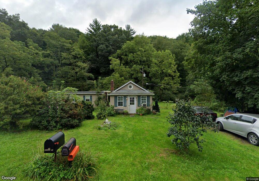
204 Troxell Valley Rd Andreas, PA 18211
Estimated Value: $125,069 - $260,000
1
Bed
1
Bath
500
Sq Ft
$360/Sq Ft
Est. Value
About This Home
This home is located at 204 Troxell Valley Rd, Andreas, PA 18211 and is currently estimated at $179,767, approximately $359 per square foot. 204 Troxell Valley Rd is a home located in Schuylkill County with nearby schools including Tamaqua Area Senior High School.
Ownership History
Date
Name
Owned For
Owner Type
Purchase Details
Closed on
Feb 24, 2016
Sold by
Wirth Frank W
Bought by
Johnson Kelly S
Current Estimated Value
Home Financials for this Owner
Home Financials are based on the most recent Mortgage that was taken out on this home.
Original Mortgage
$63,822
Outstanding Balance
$51,078
Interest Rate
3.99%
Mortgage Type
FHA
Estimated Equity
$128,689
Purchase Details
Closed on
Sep 4, 2015
Sold by
Wirth Frank W
Bought by
Dougherty Christopher and Dougherty Marcia
Purchase Details
Closed on
Aug 14, 2009
Sold by
Wirth Frank W
Bought by
Keich Theodere W and Marmas Jessica A
Purchase Details
Closed on
Jun 30, 2006
Sold by
Brotzman Thomas W
Bought by
Wirth Frank W
Create a Home Valuation Report for This Property
The Home Valuation Report is an in-depth analysis detailing your home's value as well as a comparison with similar homes in the area
Home Values in the Area
Average Home Value in this Area
Purchase History
| Date | Buyer | Sale Price | Title Company |
|---|---|---|---|
| Johnson Kelly S | $65,000 | None Available | |
| Dougherty Christopher | $36,000 | None Available | |
| Keich Theodere W | $165,000 | None Available | |
| Wirth Frank W | $155,000 | None Available |
Source: Public Records
Mortgage History
| Date | Status | Borrower | Loan Amount |
|---|---|---|---|
| Open | Johnson Kelly S | $63,822 |
Source: Public Records
Tax History Compared to Growth
Tax History
| Year | Tax Paid | Tax Assessment Tax Assessment Total Assessment is a certain percentage of the fair market value that is determined by local assessors to be the total taxable value of land and additions on the property. | Land | Improvement |
|---|---|---|---|---|
| 2025 | $2,060 | $29,835 | $21,480 | $8,355 |
| 2024 | $1,839 | $29,835 | $21,480 | $8,355 |
| 2023 | $1,839 | $29,835 | $21,480 | $8,355 |
| 2022 | $1,782 | $29,835 | $21,480 | $8,355 |
| 2021 | $1,807 | $29,835 | $21,480 | $8,355 |
| 2020 | $1,766 | $29,835 | $21,480 | $8,355 |
| 2018 | $1,710 | $29,835 | $21,480 | $8,355 |
| 2017 | $1,644 | $29,835 | $21,480 | $8,355 |
| 2015 | -- | $15,640 | $11,260 | $4,380 |
| 2011 | -- | $15,640 | $0 | $0 |
Source: Public Records
Map
Nearby Homes
- 182 Troxell Valley Rd
- 0 Troxell Valley Rd Unit 644867
- 0 Troxell Valley Rd Unit PM-79791
- 0 Troxell Valley Rd
- 118 Troxell Valley Rd
- 114 Troxell Valley Rd
- 48 Cider Run Rd
- 111 Troxell Valley Rd
- 98 Locust Ln
- 78 Walnut Ln
- 329 Troxell Valley Rd
- 120 Walnut Ln
- 97 Walnut Ln
- 52 Troxell Valley Rd
- 312 Troxell Valley Rd
- 00 Pond Dr
- 7 Lots Lime Kiln Dr
- Lot #9 W Penn Pike
- Rt 309 Residue 6a
- Lot #9 Rt 309