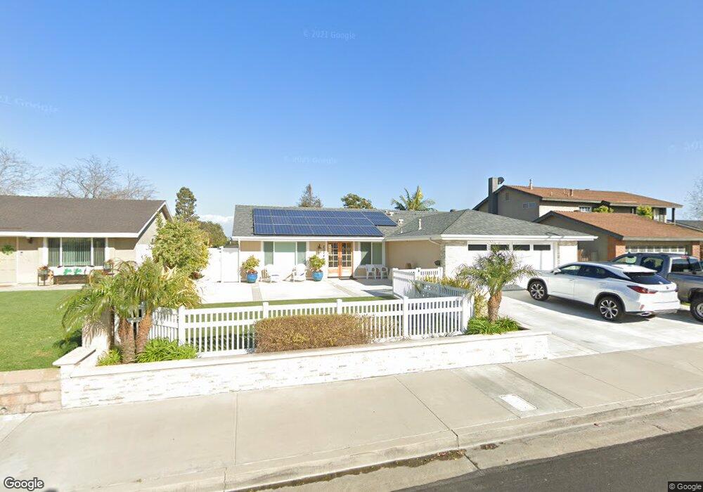
20742 Hunter Ln Huntington Beach, CA 92646
Southeast NeighborhoodEstimated Value: $1,346,742 - $1,573,000
3
Beds
2
Baths
1,519
Sq Ft
$935/Sq Ft
Est. Value
About This Home
This home is located at 20742 Hunter Ln, Huntington Beach, CA 92646 and is currently estimated at $1,419,936, approximately $934 per square foot. 20742 Hunter Ln is a home located in Orange County with nearby schools including Ralph E. Hawes Elementary School, Isaac L. Sowers Middle School, and Edison High School.
Ownership History
Date
Name
Owned For
Owner Type
Purchase Details
Closed on
Nov 9, 2020
Sold by
Cook Russell M and Schonleber Cook Linda
Bought by
Cook Russell M and Schonleber Cooke Linda
Current Estimated Value
Purchase Details
Closed on
Nov 4, 1994
Sold by
Schonleber Cook Linda Helen
Bought by
Cook Russell M
Purchase Details
Closed on
Aug 24, 1994
Sold by
Edwards Eugene P and Edwards Laurel P
Bought by
Cook Russell M
Home Financials for this Owner
Home Financials are based on the most recent Mortgage that was taken out on this home.
Original Mortgage
$162,000
Interest Rate
8.91%
Create a Home Valuation Report for This Property
The Home Valuation Report is an in-depth analysis detailing your home's value as well as a comparison with similar homes in the area
Home Values in the Area
Average Home Value in this Area
Purchase History
| Date | Buyer | Sale Price | Title Company |
|---|---|---|---|
| Cook Russell M | -- | None Available | |
| Cook Russell M | -- | Guardian Title Company | |
| Cook Russell M | $225,000 | Guardian Title Company |
Source: Public Records
Mortgage History
| Date | Status | Borrower | Loan Amount |
|---|---|---|---|
| Previous Owner | Cook Russell M | $162,000 |
Source: Public Records
Tax History Compared to Growth
Tax History
| Year | Tax Paid | Tax Assessment Tax Assessment Total Assessment is a certain percentage of the fair market value that is determined by local assessors to be the total taxable value of land and additions on the property. | Land | Improvement |
|---|---|---|---|---|
| 2025 | $5,188 | $450,807 | $270,311 | $180,496 |
| 2024 | $5,188 | $441,968 | $265,011 | $176,957 |
| 2023 | $5,068 | $433,302 | $259,814 | $173,488 |
| 2022 | $4,934 | $424,806 | $254,719 | $170,087 |
| 2021 | $4,842 | $416,477 | $249,725 | $166,752 |
| 2020 | $4,809 | $412,207 | $247,164 | $165,043 |
| 2019 | $4,752 | $404,125 | $242,318 | $161,807 |
| 2018 | $4,678 | $396,201 | $237,566 | $158,635 |
| 2017 | $4,615 | $388,433 | $232,908 | $155,525 |
| 2016 | $4,413 | $380,817 | $228,341 | $152,476 |
| 2015 | $4,138 | $353,936 | $224,911 | $129,025 |
| 2014 | $3,627 | $308,292 | $220,505 | $87,787 |
Source: Public Records
Map
Nearby Homes
- 20862 Lancelot Ln
- 9812 La Cresta Cir
- 20392 Redwood Ln
- 10101 Theseus Dr
- 21022 Manessa Cir
- 9581 Chevy Chase Dr
- 9522 Yellowstone Dr
- 21072 Galbar Cir
- 21221 Hillsdale Ln
- 21361 Lemontree Ln
- 21382 Lemontree Ln
- 9001 Oceanwood Dr
- 20442 Craimer Ln
- 8932 Amador Cir Unit 1309B
- 10172 Stonybrook Dr
- 20258 Lantana Dr
- 20071 Moontide Cir
- 20111 Marina Ln
- 8856 Sutter Cir Unit 522A
- 9695 Adams Ave
- 20732 Hunter Ln
- 20752 Hunter Ln
- 20722 Hunter Ln
- 9601 Friarscourt Dr
- 20782 Hunter Ln
- 9602 Friarscourt Dr
- 9591 Friarscourt Dr
- 9592 Erskine Dr
- 9592 Friarscourt Dr
- 20792 Hunter Ln
- 9581 Friarscourt Dr
- 20681 Iona Ln
- 20781 Hunter Ln
- 9621 Erskine Dr
- 9611 Erskine Dr
- 9582 Erskine Dr
- 9601 Erskine Dr
- 9582 Friarscourt Dr
- 20802 Hunter Ln