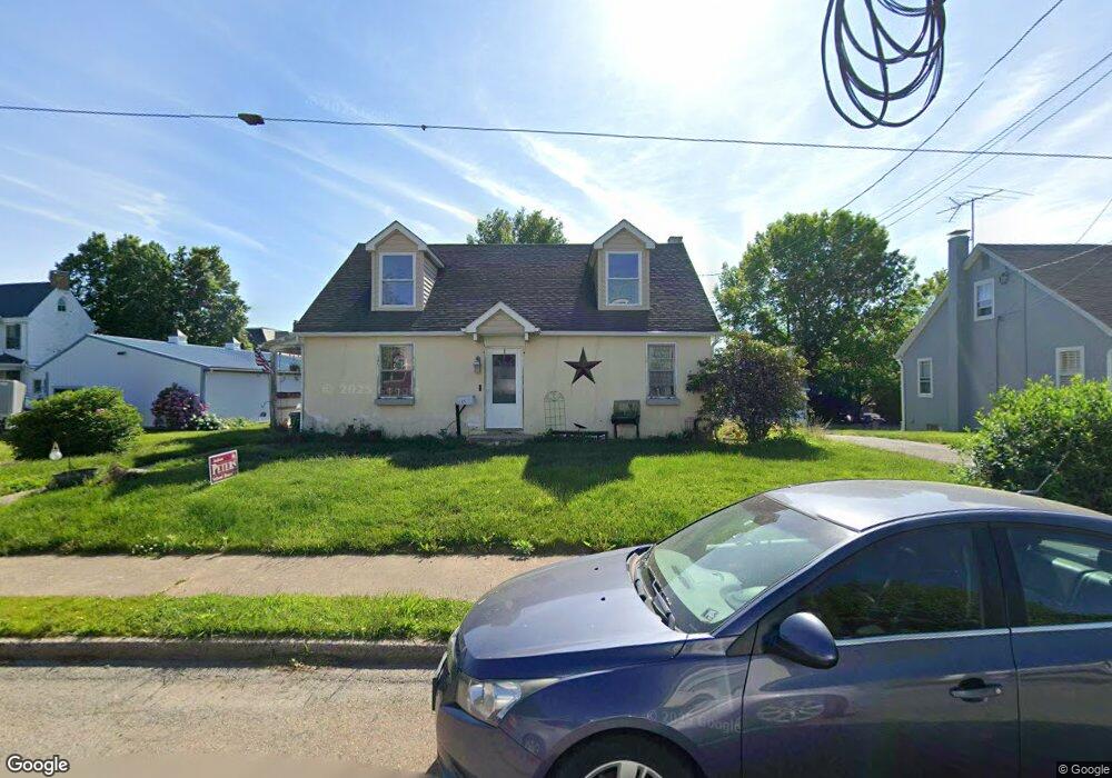
21 S 6th St Oxford, PA 19363
Estimated Value: $308,000 - $335,000
4
Beds
1
Bath
1,666
Sq Ft
$194/Sq Ft
Est. Value
About This Home
This home is located at 21 S 6th St, Oxford, PA 19363 and is currently estimated at $323,571, approximately $194 per square foot. 21 S 6th St is a home located in Chester County with nearby schools including Jordan Bank Elementary School, Nottingham School, and Elk Ridge School.
Ownership History
Date
Name
Owned For
Owner Type
Purchase Details
Closed on
Dec 31, 1998
Sold by
Wiley Elaine F and Will Of Sarah Allen
Bought by
Baird Ronald J and Baird Billie E
Current Estimated Value
Home Financials for this Owner
Home Financials are based on the most recent Mortgage that was taken out on this home.
Original Mortgage
$89,826
Outstanding Balance
$20,727
Interest Rate
6.7%
Mortgage Type
FHA
Estimated Equity
$302,844
Create a Home Valuation Report for This Property
The Home Valuation Report is an in-depth analysis detailing your home's value as well as a comparison with similar homes in the area
Home Values in the Area
Average Home Value in this Area
Purchase History
| Date | Buyer | Sale Price | Title Company |
|---|---|---|---|
| Baird Ronald J | $90,000 | Security Title Guarantee Cor |
Source: Public Records
Mortgage History
| Date | Status | Borrower | Loan Amount |
|---|---|---|---|
| Open | Baird Ronald J | $89,826 |
Source: Public Records
Tax History Compared to Growth
Tax History
| Year | Tax Paid | Tax Assessment Tax Assessment Total Assessment is a certain percentage of the fair market value that is determined by local assessors to be the total taxable value of land and additions on the property. | Land | Improvement |
|---|---|---|---|---|
| 2025 | $4,900 | $90,500 | $21,380 | $69,120 |
| 2024 | $4,900 | $90,500 | $21,380 | $69,120 |
| 2023 | $4,633 | $90,500 | $21,380 | $69,120 |
| 2022 | $4,516 | $90,500 | $21,380 | $69,120 |
| 2021 | $4,395 | $90,500 | $21,380 | $69,120 |
| 2020 | $4,329 | $90,500 | $21,380 | $69,120 |
| 2019 | $4,300 | $90,500 | $21,380 | $69,120 |
| 2018 | $4,323 | $90,500 | $21,380 | $69,120 |
| 2017 | $4,295 | $90,500 | $21,380 | $69,120 |
| 2016 | $2,760 | $90,500 | $21,380 | $69,120 |
| 2015 | $2,760 | $90,500 | $21,380 | $69,120 |
| 2014 | $2,760 | $90,500 | $21,380 | $69,120 |
Source: Public Records
Map
Nearby Homes
- 119 S 6th St
- 640 Market St
- 615 Market St
- 448 Broad St
- 16 Myrtle St
- 57 N 6th St
- 391 S 4th St
- 125 Grant St
- 128 N 4th St
- 257 Maple St
- 10 W Summit Ave
- 901 Old Library Ln
- 217 Ashleys Way
- 302 S Brookside Dr
- Parker Plan at Langston
- Arcadia Plan at Langston
- Nottingham Plan at Langston
- Covington Plan at Langston
- Devonshire Plan at Langston
- Lachlan Plan at Langston