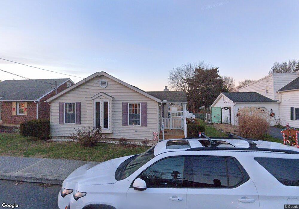
21 W Green St Camp Hill, PA 17011
Estimated Value: $258,137 - $296,000
3
Beds
1
Bath
1,250
Sq Ft
$218/Sq Ft
Est. Value
About This Home
This home is located at 21 W Green St, Camp Hill, PA 17011 and is currently estimated at $272,534, approximately $218 per square foot. 21 W Green St is a home located in Cumberland County with nearby schools including Elmwood Academy, Mechanicsburg Middle School, and Mechanicsburg Area Senior High School.
Ownership History
Date
Name
Owned For
Owner Type
Purchase Details
Closed on
Jun 10, 2005
Sold by
Semancik Andrew
Bought by
Davis Thomas
Current Estimated Value
Home Financials for this Owner
Home Financials are based on the most recent Mortgage that was taken out on this home.
Original Mortgage
$127,100
Outstanding Balance
$66,482
Interest Rate
5.79%
Mortgage Type
New Conventional
Estimated Equity
$206,052
Purchase Details
Closed on
Mar 10, 2004
Sold by
Deckman Randy
Bought by
Semancik Andrew
Create a Home Valuation Report for This Property
The Home Valuation Report is an in-depth analysis detailing your home's value as well as a comparison with similar homes in the area
Home Values in the Area
Average Home Value in this Area
Purchase History
| Date | Buyer | Sale Price | Title Company |
|---|---|---|---|
| Davis Thomas | $158,900 | -- | |
| Semancik Andrew | $41,000 | -- |
Source: Public Records
Mortgage History
| Date | Status | Borrower | Loan Amount |
|---|---|---|---|
| Open | Davis Thomas | $127,100 |
Source: Public Records
Tax History Compared to Growth
Tax History
| Year | Tax Paid | Tax Assessment Tax Assessment Total Assessment is a certain percentage of the fair market value that is determined by local assessors to be the total taxable value of land and additions on the property. | Land | Improvement |
|---|---|---|---|---|
| 2025 | $3,694 | $167,600 | $28,400 | $139,200 |
| 2024 | $3,502 | $167,600 | $28,400 | $139,200 |
| 2023 | $3,313 | $167,600 | $28,400 | $139,200 |
| 2022 | $3,222 | $167,600 | $28,400 | $139,200 |
| 2021 | $3,137 | $167,600 | $28,400 | $139,200 |
| 2020 | $3,066 | $167,600 | $28,400 | $139,200 |
| 2019 | $3,005 | $167,600 | $28,400 | $139,200 |
| 2018 | $2,953 | $167,600 | $28,400 | $139,200 |
| 2017 | $2,876 | $167,600 | $28,400 | $139,200 |
| 2016 | -- | $167,600 | $28,400 | $139,200 |
| 2015 | -- | $167,600 | $28,400 | $139,200 |
| 2014 | -- | $167,600 | $28,400 | $139,200 |
Source: Public Records
Map
Nearby Homes
- 21 W Main St
- 57 W Vine St
- 200 W Main St
- 4122 Locust Rd
- 4120 Locust Rd
- 5 William Penn Dr
- 4112 Locust Rd
- 4110 Locust Rd
- 4304 Allen Rd
- 4204 Allen Rd
- 97 Oneida Rd
- 302 Saint Marks Rd
- 9 Oakwood Cir
- 29 Kensington Dr
- 32 Hazel Cir
- 330 Charles Rd
- 4819 Brian Rd
- 116 Conodoguinet Ave
- 12 Rockaway Dr
- 77 Kensington Dr