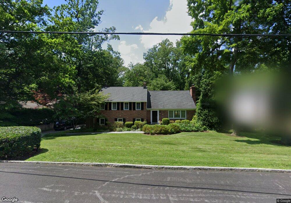
210 Comrie Dr Villanova, PA 19085
Estimated Value: $1,137,000 - $1,452,000
4
Beds
3
Baths
2,666
Sq Ft
$481/Sq Ft
Est. Value
About This Home
This home is located at 210 Comrie Dr, Villanova, PA 19085 and is currently estimated at $1,282,607, approximately $481 per square foot. 210 Comrie Dr is a home located in Delaware County with nearby schools including Radnor El School, Radnor Middle School, and Radnor Senior High School.
Ownership History
Date
Name
Owned For
Owner Type
Purchase Details
Closed on
Jun 19, 2002
Sold by
Chabot Normand and Fortin Angele
Bought by
Hobson John J and Hobson Michelle B
Current Estimated Value
Home Financials for this Owner
Home Financials are based on the most recent Mortgage that was taken out on this home.
Original Mortgage
$200,000
Outstanding Balance
$78,922
Interest Rate
5.87%
Mortgage Type
Purchase Money Mortgage
Estimated Equity
$1,203,685
Purchase Details
Closed on
Oct 10, 1994
Sold by
Taormina Kenneth C and Taormina Pamela W
Bought by
Chabot Normand and Fortin Angele
Home Financials for this Owner
Home Financials are based on the most recent Mortgage that was taken out on this home.
Original Mortgage
$180,000
Interest Rate
7.75%
Mortgage Type
Purchase Money Mortgage
Create a Home Valuation Report for This Property
The Home Valuation Report is an in-depth analysis detailing your home's value as well as a comparison with similar homes in the area
Home Values in the Area
Average Home Value in this Area
Purchase History
| Date | Buyer | Sale Price | Title Company |
|---|---|---|---|
| Hobson John J | $400,000 | Commonwealth Land Title Ins | |
| Chabot Normand | $285,000 | Commonwealth Land Title Ins |
Source: Public Records
Mortgage History
| Date | Status | Borrower | Loan Amount |
|---|---|---|---|
| Open | Hobson John J | $200,000 | |
| Previous Owner | Chabot Normand | $180,000 |
Source: Public Records
Tax History Compared to Growth
Tax History
| Year | Tax Paid | Tax Assessment Tax Assessment Total Assessment is a certain percentage of the fair market value that is determined by local assessors to be the total taxable value of land and additions on the property. | Land | Improvement |
|---|---|---|---|---|
| 2025 | $10,735 | $530,960 | $217,830 | $313,130 |
| 2024 | $10,735 | $530,960 | $217,830 | $313,130 |
| 2023 | $10,310 | $530,960 | $217,830 | $313,130 |
| 2022 | $10,197 | $530,960 | $217,830 | $313,130 |
| 2021 | $16,379 | $530,960 | $217,830 | $313,130 |
| 2020 | $9,316 | $267,810 | $124,260 | $143,550 |
| 2019 | $9,054 | $267,810 | $124,260 | $143,550 |
| 2018 | $8,876 | $267,810 | $0 | $0 |
| 2017 | $8,690 | $267,810 | $0 | $0 |
| 2016 | $1,470 | $267,810 | $0 | $0 |
| 2015 | $1,500 | $267,810 | $0 | $0 |
| 2014 | $1,470 | $267,810 | $0 | $0 |
Source: Public Records
Map
Nearby Homes
- 101 Highfield Rd
- 100 Radnor Ave
- 253 Ithan Creek Rd
- 15 Lockwood Ln
- 406 Barclay Rd
- 12 Lockwood Ln
- 200 S Ithan Ave
- 3 Lockwood Ln
- 4 Lockwood Ln
- 7 Lockwood Ln
- 625 Conestoga Rd
- 219 S Ithan Ave
- 131 Fairfax Rd
- 353 Oak Terrace
- 189 Meredith Ave
- 500 E Lancaster Ave Unit 126A
- 500 E Lancaster Ave Unit 117A
- 68 Garrett Ave
- 24 Orchard Ln
- 0 Greenwell Ln
- 208 Comrie Dr
- 212 Comrie Dr
- 190 Woodstock Rd
- 200 Woodstock Rd
- 216 Comrie Dr
- 191 Woodstock Rd
- 215 Comrie Dr
- 204 Woodstock Rd
- 186 Woodstock Rd
- 209 Hardwicke Ln
- 213 Hardwicke Ln
- 219 Comrie Dr
- 154 Vassar Cir
- 211 Comrie Dr
- 185 Woodstock Rd
- 208 Woodstock Rd
- 180 Woodstock Rd
- 191 S Spring Mill Rd
- 221 Hardwicke Ln
- 189 S Spring Mill Rd