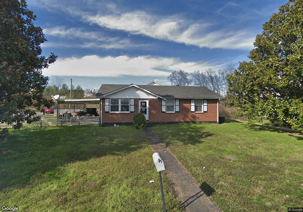
2100 W Richmond Hill Dr Nashville, TN 37207
Talbot's Corner NeighborhoodEstimated Value: $259,000 - $298,000
3
Beds
1
Bath
1,050
Sq Ft
$270/Sq Ft
Est. Value
About This Home
This home is located at 2100 W Richmond Hill Dr, Nashville, TN 37207 and is currently estimated at $283,123, approximately $269 per square foot. 2100 W Richmond Hill Dr is a home located in Davidson County with nearby schools including Alex Green Elementary School, Old Center Elementary, and Brick Church Middle School.
Ownership History
Date
Name
Owned For
Owner Type
Purchase Details
Closed on
Feb 5, 2013
Sold by
U S Bank National Association
Bought by
Cook Marvin
Current Estimated Value
Purchase Details
Closed on
May 14, 2012
Sold by
Beechum Reginald and Beechum Katherine D
Bought by
U S Bank National Associaiton
Purchase Details
Closed on
Jul 16, 1998
Sold by
Harned Thomas Marion
Bought by
Queen Melba Ann and Harned Frank Wayne
Create a Home Valuation Report for This Property
The Home Valuation Report is an in-depth analysis detailing your home's value as well as a comparison with similar homes in the area
Home Values in the Area
Average Home Value in this Area
Purchase History
| Date | Buyer | Sale Price | Title Company |
|---|---|---|---|
| Cook Marvin | $32,900 | None Available | |
| U S Bank National Associaiton | $35,700 | None Available | |
| Queen Melba Ann | -- | -- |
Source: Public Records
Tax History Compared to Growth
Tax History
| Year | Tax Paid | Tax Assessment Tax Assessment Total Assessment is a certain percentage of the fair market value that is determined by local assessors to be the total taxable value of land and additions on the property. | Land | Improvement |
|---|---|---|---|---|
| 2024 | $1,289 | $39,625 | $10,500 | $29,125 |
| 2023 | $1,289 | $39,625 | $10,500 | $29,125 |
| 2022 | $1,289 | $39,625 | $10,500 | $29,125 |
| 2021 | $1,303 | $39,625 | $10,500 | $29,125 |
| 2020 | $1,064 | $25,200 | $3,625 | $21,575 |
| 2019 | $795 | $25,200 | $3,625 | $21,575 |
| 2018 | $795 | $25,200 | $3,625 | $21,575 |
| 2017 | $795 | $25,200 | $3,625 | $21,575 |
| 2016 | $770 | $17,050 | $3,500 | $13,550 |
| 2015 | $770 | $17,050 | $3,500 | $13,550 |
| 2014 | $770 | $17,050 | $3,500 | $13,550 |
Source: Public Records
Map
Nearby Homes
- 3133 Greggwood Dr
- 2144 W Richmond Hill Dr
- 3205 Ewingdale Dr
- 456 Ewing Ln
- 2941 Vista Ln
- 439 Ewing Dr
- 3183 Bridgepoint Dr
- 430 Ewing Dr
- 3027 Capps Dr
- 0 Ewing Dr Unit RTC2807170
- 0 Ewing Dr Unit RTC3011325
- 0 Ewing Dr Unit RTC2989232
- 2712 Vista Ln
- 308 Vista Cove
- 3103 Brick Church Pike
- 804 Willow Trace Ct
- 388 Ewing Dr
- 509 Brick Church Ln
- 3214 Doverside Dr
- 3205 Leswood Ln
- 3193 Gwynnwood Dr
- 2101 W Richmond Hill Dr
- 2108 W Richmond Hill Dr
- 3184 Gwynnwood Dr
- 2105 W Richmond Hill Dr
- 3188 Gwynnwood Dr
- 2112 W Richmond Hill Dr
- 3181 Gwynnwood Dr
- 2109 W Richmond Hill Dr
- 3099 Richmond Hill Dr
- 3177 Gwynnwood Dr
- 2116 W Richmond Hill Dr
- 2113 W Richmond Hill Dr
- 3176 Gwynnwood Dr
- 2117 W Richmond Hill Dr
- 2120 W Richmond Hill Dr
- 3104 Ewingwood Dr
- 3002 Ewingdale Dr
- 3100 Ewingwood Dr
- 3108 Ewingwood Dr