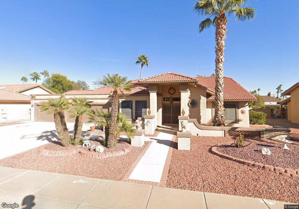
21011 N Desert Sands Dr Sun City West, AZ 85375
Estimated Value: $523,369 - $671,000
--
Bed
3
Baths
2,692
Sq Ft
$220/Sq Ft
Est. Value
About This Home
This home is located at 21011 N Desert Sands Dr, Sun City West, AZ 85375 and is currently estimated at $592,842, approximately $220 per square foot. 21011 N Desert Sands Dr is a home located in Maricopa County with nearby schools including Arizona Charter Academy and FourteenSix Christian Academy.
Ownership History
Date
Name
Owned For
Owner Type
Purchase Details
Closed on
Jun 17, 2022
Sold by
Sanders Rodney L
Bought by
Sanders Dennis L and Sanders Sharon M
Current Estimated Value
Home Financials for this Owner
Home Financials are based on the most recent Mortgage that was taken out on this home.
Original Mortgage
$480,000
Outstanding Balance
$458,677
Interest Rate
5.78%
Mortgage Type
New Conventional
Estimated Equity
$134,165
Purchase Details
Closed on
Apr 14, 2000
Sold by
Wells Fargo Bank
Bought by
Sanders Rodney L and Sanders Charon
Home Financials for this Owner
Home Financials are based on the most recent Mortgage that was taken out on this home.
Original Mortgage
$164,000
Interest Rate
8.22%
Mortgage Type
New Conventional
Create a Home Valuation Report for This Property
The Home Valuation Report is an in-depth analysis detailing your home's value as well as a comparison with similar homes in the area
Home Values in the Area
Average Home Value in this Area
Purchase History
| Date | Buyer | Sale Price | Title Company |
|---|---|---|---|
| Sanders Dennis L | $600,000 | First American Title | |
| Sanders Rodney L | $214,000 | First American Title |
Source: Public Records
Mortgage History
| Date | Status | Borrower | Loan Amount |
|---|---|---|---|
| Open | Sanders Dennis L | $480,000 | |
| Previous Owner | Sanders Rodney L | $164,000 |
Source: Public Records
Tax History Compared to Growth
Tax History
| Year | Tax Paid | Tax Assessment Tax Assessment Total Assessment is a certain percentage of the fair market value that is determined by local assessors to be the total taxable value of land and additions on the property. | Land | Improvement |
|---|---|---|---|---|
| 2025 | $2,708 | $33,677 | -- | -- |
| 2024 | $2,461 | $22,982 | -- | -- |
| 2023 | $2,461 | $38,400 | $7,680 | $30,720 |
| 2022 | $2,068 | $31,260 | $6,250 | $25,010 |
| 2021 | $2,156 | $28,970 | $5,790 | $23,180 |
| 2020 | $2,103 | $27,700 | $5,540 | $22,160 |
| 2019 | $2,060 | $25,130 | $5,020 | $20,110 |
| 2018 | $2,005 | $24,310 | $4,860 | $19,450 |
| 2017 | $1,929 | $23,110 | $4,620 | $18,490 |
| 2016 | $1,132 | $21,950 | $4,390 | $17,560 |
| 2015 | $1,786 | $21,110 | $4,220 | $16,890 |
Source: Public Records
Map
Nearby Homes
- 13547 W Sky Hawk Dr
- 13450 W Stardust Blvd Unit 20A
- 13725 W Springdale Dr
- 13711 W Gable Hill Dr
- 13819 W Elmbrook Dr
- 13718 W Gable Hill Dr
- 13812 W Pinetree Dr
- 13619 W Meeker Blvd
- 13440 W Caraway Dr
- 13451 W Ballad Dr
- 13447 W Ballad Dr
- 13436 W Caraway Dr
- 13709 W Whitewood Dr
- 13635 W Meeker Blvd
- 13406 W Stardust Blvd
- 13667 W Meeker Blvd Unit IE
- 13910 W Oak Glen Dr
- 20226 N Broken Arrow Dr
- 13222 W Castlebar Dr
- 13218 W Castlebar Dr
- 21007 N Desert Sands Dr
- 21014 N 135th Ave
- 21008 N 135th Ave
- 21010 N Desert Sands Dr
- 21022 N 135th Ave
- 21014 N Desert Sands Dr
- 21003 N Desert Sands Dr
- 21006 N Desert Sands Dr
- 21002 N 135th Ave
- 21018 N Desert Sands Dr
- 21030 N 135th Ave
- 21023 N Desert Sands Dr
- 21022 N Desert Sands Dr
- 21038 N 135th Ave
- 20823 N Desert Sands Dr
- 20825 N Desert Sands Dr
- 20822 N 135th Ave
- 21027 N Desert Sands Dr
- 20826 N Desert Sands Dr Unit 30
- 21046 N 135th Ave