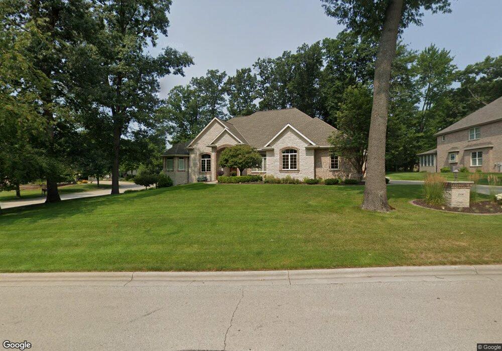
2116 Muirwood Ln Green Bay, WI 54313
Westside NeighborhoodEstimated Value: $711,000 - $1,003,078
--
Bed
--
Bath
--
Sq Ft
0.55
Acres
About This Home
This home is located at 2116 Muirwood Ln, Green Bay, WI 54313 and is currently estimated at $855,770. 2116 Muirwood Ln is a home located in Brown County with nearby schools including King Elementary School, Lombardi Middle School, and Southwest High School.
Ownership History
Date
Name
Owned For
Owner Type
Purchase Details
Closed on
Oct 30, 2024
Sold by
Mcmullen Mary M and Mcmullen Y
Bought by
Mark J J and Mark Mary M
Current Estimated Value
Purchase Details
Closed on
Dec 21, 2007
Sold by
Dahlin Stephanie L and Giannunzio Stephanie L
Bought by
Mcmullen Mark J and Mcmullen Mary M
Purchase Details
Closed on
Oct 18, 2001
Sold by
Ogdan Woods Partnership
Bought by
Dahlin Stephanie L
Create a Home Valuation Report for This Property
The Home Valuation Report is an in-depth analysis detailing your home's value as well as a comparison with similar homes in the area
Home Values in the Area
Average Home Value in this Area
Purchase History
| Date | Buyer | Sale Price | Title Company |
|---|---|---|---|
| Mark J J | -- | -- | |
| Mcmullen Mary M | -- | -- | |
| Mcmullen Mark J | $105,000 | Bay Title | |
| Dahlin Stephanie L | $89,900 | -- |
Source: Public Records
Tax History Compared to Growth
Tax History
| Year | Tax Paid | Tax Assessment Tax Assessment Total Assessment is a certain percentage of the fair market value that is determined by local assessors to be the total taxable value of land and additions on the property. | Land | Improvement |
|---|---|---|---|---|
| 2024 | $13,178 | $676,200 | $71,800 | $604,400 |
| 2023 | $12,726 | $676,200 | $71,800 | $604,400 |
| 2022 | $12,341 | $676,200 | $71,800 | $604,400 |
| 2021 | $15,785 | $648,900 | $112,900 | $536,000 |
| 2020 | $15,739 | $648,900 | $112,900 | $536,000 |
| 2019 | $15,355 | $648,900 | $112,900 | $536,000 |
| 2018 | $14,934 | $648,900 | $112,900 | $536,000 |
| 2017 | $14,596 | $648,900 | $112,900 | $536,000 |
| 2016 | $14,398 | $648,900 | $112,900 | $536,000 |
| 2015 | $14,396 | $648,900 | $112,900 | $536,000 |
| 2014 | $15,115 | $648,900 | $112,900 | $536,000 |
| 2013 | $15,115 | $648,900 | $112,900 | $536,000 |
Source: Public Records
Map
Nearby Homes
- 2768 Independence Dr
- 1940 Renaissance Ct
- 3023 Crusade Ln
- 1602 W Crusade Ln
- 3097 S Sandstone Ct
- 3096 S Sandstone Ct
- 1680 Cormier Rd
- 1310 Sandstone Place
- 1433 Baumgart Rd Unit 1435
- 2060 Wintergreen Ct
- 2993 Fleetwood Dr
- 2044 Ann Ln
- 3102 Sandstone Ct
- 2550 He Nis Ra Ln
- 2466 Parkwood Dr
- 1570 Mesa Dr
- 3379 Belmar Rd
- 916 Square Terrace
- 1000 Rolling Green Dr
- 2689 Clive St
- 2098 Muirwood Ln
- 2105 W Muirwood Dr
- 2119 Muirwood Ln
- 2961 Shelter Creek Ln
- 2950 2950 Shelter Creek
- 2965 Shelter Creek Ln
- 2091 W Muirwood Dr
- 2975 Shelter Creek Ln
- 2094 Muirwood Ln
- 2951 Shelter Creek Ct
- 2939 Parkwood Dr
- 2975 Shelter Creek Ln
- 2081 W Muirwood Dr
- 2940 Shelter Creek Ct Unit 1
- 2943 Shelter Creek Ct
- 2985 Shelter Creek Ln
- 2933 Parkwood Dr
- 2963 N Muirwood Dr
- 2080 Muirwood Ln
- 2934 Shelter Creek Ct