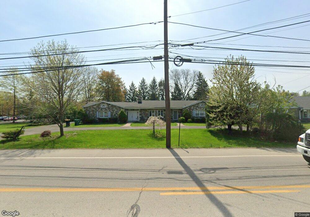
2121 N Broad St Lansdale, PA 19446
Estimated Value: $525,000 - $611,000
3
Beds
2
Baths
1,780
Sq Ft
$321/Sq Ft
Est. Value
About This Home
This home is located at 2121 N Broad St, Lansdale, PA 19446 and is currently estimated at $570,873, approximately $320 per square foot. 2121 N Broad St is a home located in Montgomery County with nearby schools including A. M. Kulp Elementary School, Penndale Middle School, and North Penn Senior High School.
Ownership History
Date
Name
Owned For
Owner Type
Purchase Details
Closed on
Jan 11, 2005
Sold by
Walsh Donald J
Bought by
Gouda Yasser and Kandil Amany N
Current Estimated Value
Purchase Details
Closed on
Feb 1, 2001
Sold by
Walsh Donald J and Walsh Marie C
Bought by
Walsh Donald J
Create a Home Valuation Report for This Property
The Home Valuation Report is an in-depth analysis detailing your home's value as well as a comparison with similar homes in the area
Home Values in the Area
Average Home Value in this Area
Purchase History
| Date | Buyer | Sale Price | Title Company |
|---|---|---|---|
| Gouda Yasser | $399,000 | First American Title Ins Co | |
| Walsh Donald J | $195,000 | -- |
Source: Public Records
Mortgage History
| Date | Status | Borrower | Loan Amount |
|---|---|---|---|
| Closed | Gouda Yasser | $0 |
Source: Public Records
Tax History Compared to Growth
Tax History
| Year | Tax Paid | Tax Assessment Tax Assessment Total Assessment is a certain percentage of the fair market value that is determined by local assessors to be the total taxable value of land and additions on the property. | Land | Improvement |
|---|---|---|---|---|
| 2025 | $6,908 | $172,550 | $54,920 | $117,630 |
| 2024 | $6,908 | $172,550 | $54,920 | $117,630 |
| 2023 | $6,612 | $172,550 | $54,920 | $117,630 |
| 2022 | $6,397 | $172,550 | $54,920 | $117,630 |
| 2021 | $6,215 | $172,550 | $54,920 | $117,630 |
| 2020 | $6,068 | $172,550 | $54,920 | $117,630 |
| 2019 | $5,967 | $172,550 | $54,920 | $117,630 |
| 2018 | $5,967 | $172,550 | $54,920 | $117,630 |
| 2017 | $5,739 | $172,550 | $54,920 | $117,630 |
| 2016 | $5,672 | $172,550 | $54,920 | $117,630 |
| 2015 | $5,445 | $172,550 | $54,920 | $117,630 |
| 2014 | $5,445 | $172,550 | $54,920 | $117,630 |
Source: Public Records
Map
Nearby Homes
- 2111 Hidden Meadow Dr
- 1823 N Line St
- 000 Lenape Dr
- 0002 Sydney Ln
- 5 Fortuna Dr
- 6 Fortuna Dr
- 9 Fortuna Dr
- 8 Fortuna Dr
- 6 Lantern Ln
- 83 Bethlehem Pike Unit 1213 FIRESTONE
- 83 Bethlehem Pike Unit 1106- MADISON PLAN
- 401 Sadie Ave
- 373 Sydney Ln
- 381 Sydney Ave
- 375 Sydney Ln
- Warwick Plan at Sterling Walk
- Stratford Plan at Sterling Walk
- 100 Victoria Dr
- 304 Victoria Dr
- 417 Wynstone Ct
- 2119 N Broad St
- 2124 Hidden Meadow Dr
- 2102 Hidden Meadow Dr
- 2122 Hidden Meadow Dr
- 2120 Hidden Meadow Dr
- 2131 N Broad St
- 2131 N Broad St Unit SUITE 100
- 2131 N Broad St Unit SUITE 1
- 2131 N Broad St Unit SUITE 2
- 2106 Hidden Meadow Dr
- 2118 Hidden Meadow Dr
- 2151 Hidden Meadow Dr
- 2108 Hidden Meadow Dr
- 2147 Hidden Meadow Dr
- 2101 Hidden Meadow Dr
- 2116 Hidden Meadow Dr
- 2145 Hidden Meadow Dr
- 2200 N Broad St Unit REAR
- 2200 N Broad St
- 2103 N Broad St