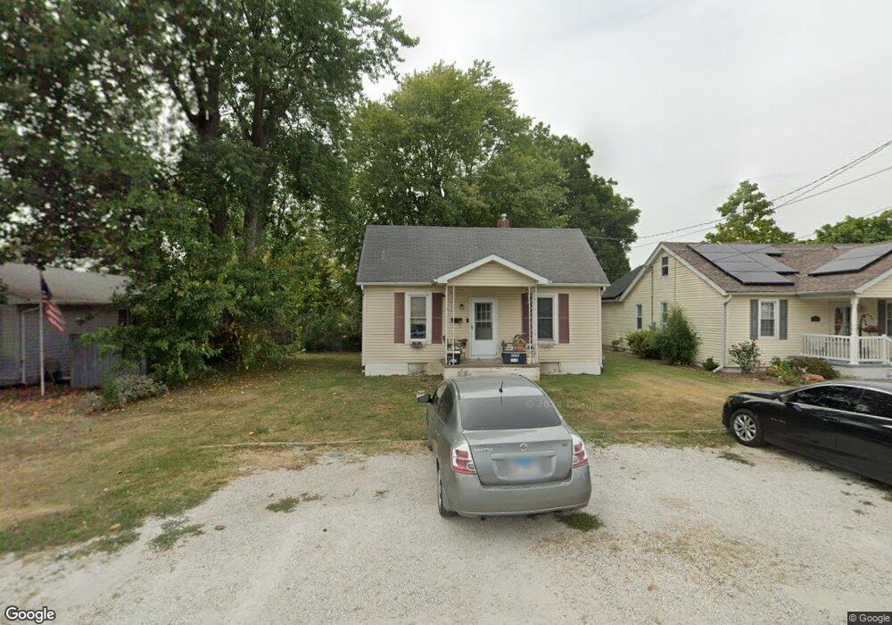
213 Curtis St Jerseyville, IL 62052
Estimated Value: $92,000 - $112,000
--
Bed
--
Bath
921
Sq Ft
$106/Sq Ft
Est. Value
About This Home
This home is located at 213 Curtis St, Jerseyville, IL 62052 and is currently estimated at $97,908, approximately $106 per square foot. 213 Curtis St is a home located in Jersey County with nearby schools including Jersey Community High School, St Francis/Holy Ghost Catholic School, and Victory Baptist School.
Ownership History
Date
Name
Owned For
Owner Type
Purchase Details
Closed on
Mar 31, 2010
Sold by
Bray Michael
Bought by
Lester Wayne L and Lester Mary E
Current Estimated Value
Home Financials for this Owner
Home Financials are based on the most recent Mortgage that was taken out on this home.
Original Mortgage
$96,000
Interest Rate
4.6%
Purchase Details
Closed on
Dec 31, 2009
Sold by
Taylor Bean And Whitaker Mortgage Corp
Bought by
Lester Wayne L and Lester Mary E
Purchase Details
Closed on
Nov 5, 2008
Sold by
Sheriff Of Jersey County
Bought by
Taylor Bean And Whitaker Mortgage Corp
Create a Home Valuation Report for This Property
The Home Valuation Report is an in-depth analysis detailing your home's value as well as a comparison with similar homes in the area
Home Values in the Area
Average Home Value in this Area
Purchase History
| Date | Buyer | Sale Price | Title Company |
|---|---|---|---|
| Lester Wayne L | -- | -- | |
| Lester Wayne L | $30,000 | -- | |
| Taylor Bean And Whitaker Mortgage Corp | -- | -- |
Source: Public Records
Mortgage History
| Date | Status | Borrower | Loan Amount |
|---|---|---|---|
| Previous Owner | Lester Wayne L | $96,000 |
Source: Public Records
Tax History Compared to Growth
Tax History
| Year | Tax Paid | Tax Assessment Tax Assessment Total Assessment is a certain percentage of the fair market value that is determined by local assessors to be the total taxable value of land and additions on the property. | Land | Improvement |
|---|---|---|---|---|
| 2024 | $2,266 | $29,275 | $5,580 | $23,695 |
| 2023 | $2,173 | $27,360 | $5,215 | $22,145 |
| 2022 | $2,100 | $25,570 | $4,875 | $20,695 |
| 2021 | $2,025 | $24,235 | $4,620 | $19,615 |
| 2020 | $1,918 | $23,300 | $4,440 | $18,860 |
| 2019 | $1,918 | $22,730 | $4,330 | $18,400 |
| 2018 | $1,858 | $22,565 | $4,300 | $18,265 |
| 2017 | $1,888 | $22,400 | $4,270 | $18,130 |
| 2016 | $1,896 | $22,555 | $4,300 | $18,255 |
| 2015 | -- | $22,900 | $4,365 | $18,535 |
| 2014 | -- | $22,935 | $4,370 | $18,565 |
Source: Public Records
Map
Nearby Homes
- 514 Maple Ave
- 114 & 112 Andrew Ave
- 205 Leonard Ave
- 315 E Prairie St
- 201 W Barr Ave
- 205 W Barr Ave
- 606 E Carpenter St
- 100 Morean St
- 112 Krause St
- 110 Krause St
- 505 S Lafayette St
- 405 E Arch St
- 709 Henry St
- 0 E Pearl St
- 512 S June St
- 103 Deye St
- 419 E Exchange St
- 705 S Arch St
- 418 Short St
- 1120 S Liberty St