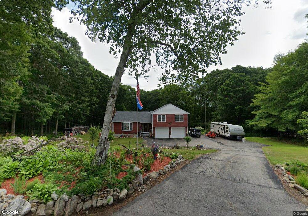
213 Henshaw St Leicester, MA 01524
Estimated Value: $514,000 - $553,763
3
Beds
3
Baths
2,124
Sq Ft
$251/Sq Ft
Est. Value
About This Home
This home is located at 213 Henshaw St, Leicester, MA 01524 and is currently estimated at $533,691, approximately $251 per square foot. 213 Henshaw St is a home located in Worcester County with nearby schools including Leicester Integrated Preschool, Leicester Memorial Elementary School, and Leicester Middle School.
Ownership History
Date
Name
Owned For
Owner Type
Purchase Details
Closed on
Sep 11, 2024
Sold by
Arrus Jr Ronald L Est and Cortes
Bought by
Ronald L Barrus Jr T L and Ronald Cortes
Current Estimated Value
Purchase Details
Closed on
Dec 9, 2021
Sold by
Barrus Olga O and Barrus Ronald L
Bought by
Barrus Ronald L
Purchase Details
Closed on
Jan 19, 1996
Sold by
Shelveer Vest Inc
Bought by
Barrus Ronald and Barrus Olga
Create a Home Valuation Report for This Property
The Home Valuation Report is an in-depth analysis detailing your home's value as well as a comparison with similar homes in the area
Home Values in the Area
Average Home Value in this Area
Purchase History
| Date | Buyer | Sale Price | Title Company |
|---|---|---|---|
| Ronald L Barrus Jr T L | -- | None Available | |
| Ronald L Barrus Jr T L | -- | None Available | |
| Barrus Ronald L | -- | None Available | |
| Barrus Ronald L | -- | None Available | |
| Barrus Ronald | $30,000 | -- | |
| Barrus Ronald | $30,000 | -- |
Source: Public Records
Tax History Compared to Growth
Tax History
| Year | Tax Paid | Tax Assessment Tax Assessment Total Assessment is a certain percentage of the fair market value that is determined by local assessors to be the total taxable value of land and additions on the property. | Land | Improvement |
|---|---|---|---|---|
| 2025 | $55 | $463,600 | $86,000 | $377,600 |
| 2024 | $5,189 | $413,500 | $74,500 | $339,000 |
| 2023 | $4,928 | $383,200 | $74,500 | $308,700 |
| 2022 | $4,752 | $339,700 | $71,300 | $268,400 |
| 2021 | $5,111 | $337,800 | $71,300 | $266,500 |
| 2020 | $4,650 | $311,900 | $67,500 | $244,400 |
| 2019 | $4,465 | $296,100 | $60,900 | $235,200 |
| 2018 | $4,270 | $265,400 | $60,900 | $204,500 |
| 2017 | $4,065 | $262,600 | $60,900 | $201,700 |
| 2016 | $3,999 | $268,400 | $75,300 | $193,100 |
| 2015 | $3,903 | $268,400 | $75,300 | $193,100 |
Source: Public Records
Map
Nearby Homes
- 285 Henshaw St
- 135 Henshaw St
- 164 Peter Salem Rd
- 664 Stafford St
- 500 Main St
- 19 Laurelwood Ave
- 381 Pleasant St
- 2 Crestwood Rd
- 75 Huntoon Memorial Hwy Unit 1-2
- 75 Huntoon Memorial Hwy Unit 1-3
- 23 South St
- 19 South St
- 473 Pleasant St
- 2 Victor Ave
- 315 Stafford St
- 10 Edward St
- 3 Edward St Unit 3
- 27 Havana Rd
- 6 Brickyard Rd
- 1511 Main St Unit C405
- 217 Henshaw St
- 220 Henshaw St
- 211 Henshaw St
- 1 Autumn Ln
- 2 Shelter Ridge Rd
- 210 Henshaw St
- 4 Shelter Ridge Rd
- 3 Autumn Ln
- 200 Henshaw St
- 250 Henshaw St
- 6 Shelter Ridge Rd
- 197 Henshaw St
- 198 Henshaw St
- 6 Autumn Ln
- 5 Autumn Ln
- 50 Autumn Ln
- 262 Henshaw St
- 3 Shelter Ridge Rd
- 8 Shelter Ridge Rd
- 10 Shelter Ridge Rd