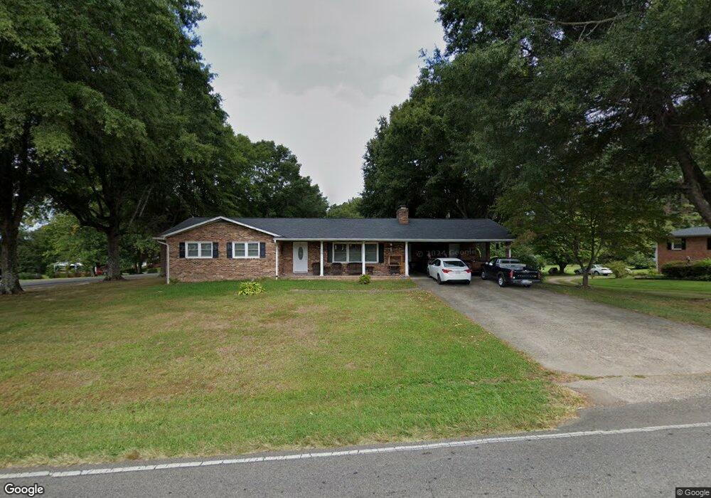
216 Arlington St Mount Airy, NC 27030
Estimated Value: $270,000 - $306,000
3
Beds
2
Baths
1,596
Sq Ft
$175/Sq Ft
Est. Value
About This Home
This home is located at 216 Arlington St, Mount Airy, NC 27030 and is currently estimated at $279,929, approximately $175 per square foot. 216 Arlington St is a home located in Surry County with nearby schools including Bruce H. Tharrington Elementary School, Mount Airy Middle School, and Mount Airy High School.
Ownership History
Date
Name
Owned For
Owner Type
Purchase Details
Closed on
Jul 2, 2013
Sold by
Martin Holder Brenda Bottoms and Holder Michael W
Bought by
Martin Brandon
Current Estimated Value
Home Financials for this Owner
Home Financials are based on the most recent Mortgage that was taken out on this home.
Original Mortgage
$65,000
Interest Rate
4.58%
Mortgage Type
Credit Line Revolving
Purchase Details
Closed on
May 1, 2000
Purchase Details
Closed on
May 1, 1993
Purchase Details
Closed on
May 1, 1990
Purchase Details
Closed on
Apr 1, 1985
Purchase Details
Closed on
Apr 1, 1970
Create a Home Valuation Report for This Property
The Home Valuation Report is an in-depth analysis detailing your home's value as well as a comparison with similar homes in the area
Home Values in the Area
Average Home Value in this Area
Purchase History
| Date | Buyer | Sale Price | Title Company |
|---|---|---|---|
| Martin Brandon | -- | None Available | |
| -- | $125,000 | -- | |
| -- | -- | -- | |
| -- | -- | -- | |
| -- | -- | -- | |
| -- | -- | -- |
Source: Public Records
Mortgage History
| Date | Status | Borrower | Loan Amount |
|---|---|---|---|
| Previous Owner | Martin Brandon | $65,000 |
Source: Public Records
Tax History Compared to Growth
Tax History
| Year | Tax Paid | Tax Assessment Tax Assessment Total Assessment is a certain percentage of the fair market value that is determined by local assessors to be the total taxable value of land and additions on the property. | Land | Improvement |
|---|---|---|---|---|
| 2025 | $1,329 | $205,530 | $18,900 | $186,630 |
| 2024 | $1,148 | $159,120 | $14,700 | $144,420 |
| 2023 | $1,131 | $159,120 | $14,700 | $144,420 |
| 2022 | $1,132 | $159,120 | $14,700 | $144,420 |
| 2021 | $1,151 | $159,120 | $14,700 | $144,420 |
| 2020 | $1,126 | $147,940 | $14,700 | $133,240 |
| 2019 | $1,124 | $147,940 | $0 | $0 |
| 2018 | $1,025 | $141,490 | $0 | $0 |
| 2017 | $1,082 | $141,490 | $0 | $0 |
| 2016 | $1,071 | $141,490 | $0 | $0 |
| 2013 | -- | $139,990 | $0 | $0 |
Source: Public Records
Map
Nearby Homes
- 1610 E Wensley Dr
- 1513 Pittman St
- TBD S Andy Griffith Pkwy
- 00 S Andy Griffith Pkwy
- .58 Newsome St
- 1023 Spring St
- 01 Farmbrook Rd
- 000000 Farmbrook Rd
- 00000 Farmbrook Rd
- 02 Farmbrook Rd
- 00 Farmbrook Rd
- 226 Hamburg St
- 1122 Viewland Ave
- Tbd Farmbrook Rd
- 802 Spring St
- 00 Hillcrest Dr
- 220 Broad St
- 704 E Haymore St
- 214 Broad St
- 722 Maiden Ln
- 212 Arlington St
- 1541 W Wensley Dr Unit DRW
- 300 Arlington St
- 208 Arlington St
- 1601 E Wensley Dr
- 104 Vernon Cir
- 205 Arlington St
- 1540 W Wensley Dr Unit DRW
- 304 Arlington St
- 301 Arlington St
- 1537 W Wensley Dr Unit DRW
- 1536 W Wensley Dr Unit DRW
- 201 Arlington St
- 305 Arlington St
- 1605 E Wensley Dr
- 1604 E Wensley Dr
- 105 Burnley Ln
- 1533 W Wensley Dr Unit DRW
- 200 Arlington St
- 1541 W Fairfield Dr Unit DRW