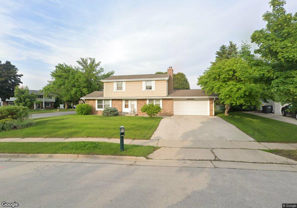
2165 Laura Ln Waukesha, WI 53186
Estimated Value: $388,000 - $425,000
4
Beds
2
Baths
1,921
Sq Ft
$210/Sq Ft
Est. Value
About This Home
This home is located at 2165 Laura Ln, Waukesha, WI 53186 and is currently estimated at $404,297, approximately $210 per square foot. 2165 Laura Ln is a home located in Waukesha County with nearby schools including John F. Miller School, Banting Elementary School, and Horning Middle School.
Ownership History
Date
Name
Owned For
Owner Type
Purchase Details
Closed on
Apr 13, 2023
Sold by
Oconomowoc Residential Programs Inc
Bought by
Love Tenisha
Current Estimated Value
Home Financials for this Owner
Home Financials are based on the most recent Mortgage that was taken out on this home.
Original Mortgage
$307,800
Outstanding Balance
$299,246
Interest Rate
6.6%
Mortgage Type
New Conventional
Estimated Equity
$105,052
Create a Home Valuation Report for This Property
The Home Valuation Report is an in-depth analysis detailing your home's value as well as a comparison with similar homes in the area
Home Values in the Area
Average Home Value in this Area
Purchase History
| Date | Buyer | Sale Price | Title Company |
|---|---|---|---|
| Love Tenisha | $324,000 | None Listed On Document |
Source: Public Records
Mortgage History
| Date | Status | Borrower | Loan Amount |
|---|---|---|---|
| Open | Love Tenisha | $307,800 |
Source: Public Records
Tax History Compared to Growth
Tax History
| Year | Tax Paid | Tax Assessment Tax Assessment Total Assessment is a certain percentage of the fair market value that is determined by local assessors to be the total taxable value of land and additions on the property. | Land | Improvement |
|---|---|---|---|---|
| 2024 | $6,202 | $342,100 | $69,200 | $272,900 |
| 2023 | $5,323 | $342,100 | $69,200 | $272,900 |
| 2022 | $4,704 | $234,400 | $62,600 | $171,800 |
| 2021 | $4,829 | $234,400 | $62,600 | $171,800 |
| 2020 | $4,615 | $234,400 | $62,600 | $171,800 |
| 2019 | $4,498 | $234,400 | $62,600 | $171,800 |
| 2018 | $4,231 | $217,000 | $54,200 | $162,800 |
| 2017 | $4,539 | $217,000 | $54,200 | $162,800 |
| 2016 | $4,066 | $197,300 | $54,200 | $143,100 |
| 2015 | $4,029 | $197,300 | $54,200 | $143,100 |
| 2014 | $4,079 | $193,400 | $54,200 | $139,200 |
| 2013 | $4,079 | $193,400 | $54,200 | $139,200 |
Source: Public Records
Map
Nearby Homes
- 2423 Kossow Rd
- 2109 Melody Ln
- 335 Kossow Rd
- 1729 Stardust Dr Unit B
- 21525 Belgren Rd
- 1080 Westbrooke Pkwy
- 1155 Gray Fox Hollow Ct
- Lt1 Davidson Rd
- 1415 Niagara St Unit 109
- 1112 Gertrude St
- 1333 Niagara St
- 1116 Josephine St
- 1308 Danny St
- 1732 S Craftsman Dr
- 1471 Cleveland Ave
- 918 Niagara St
- S17W22650 Lincoln Ave
- 19770 Foxkirk Ct
- 550 McPride Ln Unit B
- 1930 Cotton Tail Ln
- 2132 Ruben Dr Unit 2134
- 2159 Laura Ln
- 2127 Ruben Dr
- 2136 Ruben Dr
- 2128 Ruben Dr
- 2153 Laura Ln
- 2124 Ruben Dr
- 2147 Laura Ln
- 2146 Laura Ln
- 2121 Ruben Dr
- 2120 Ruben Dr
- 2141 Laura Ct
- 2115 Ruben Dr
- 2112 Ruben Dr
- 2400 Springdale Rd
- 2124 Laura Ln
- 2109 Ruben Dr
- 2135 Laura Ct
- 2114 Laura Ln
- 2104 Ruben Dr Unit 6