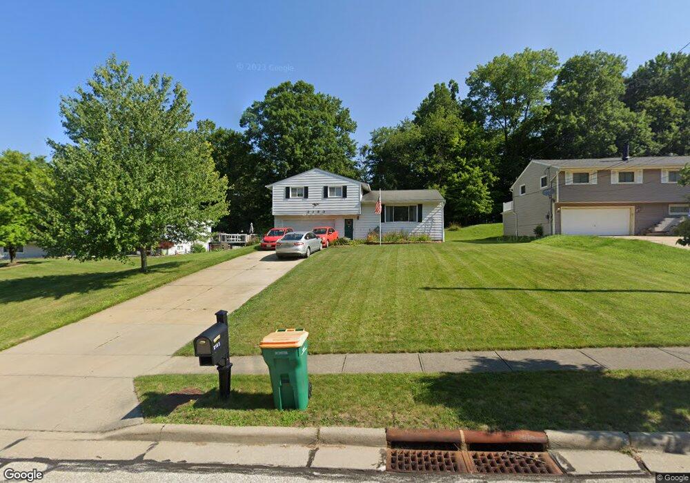
2183 Sherwin Dr Twinsburg, OH 44087
Estimated Value: $274,000 - $289,000
3
Beds
2
Baths
1,714
Sq Ft
$166/Sq Ft
Est. Value
About This Home
This home is located at 2183 Sherwin Dr, Twinsburg, OH 44087 and is currently estimated at $283,732, approximately $165 per square foot. 2183 Sherwin Dr is a home located in Summit County with nearby schools including Wilcox Primary School, Samuel Bissell Elementary School, and Dodge Intermediate School.
Ownership History
Date
Name
Owned For
Owner Type
Purchase Details
Closed on
Jul 29, 2003
Sold by
Sellman Judith
Bought by
Zemanek Craig and Zemanek Vicki R
Current Estimated Value
Home Financials for this Owner
Home Financials are based on the most recent Mortgage that was taken out on this home.
Original Mortgage
$115,000
Interest Rate
5.3%
Mortgage Type
Purchase Money Mortgage
Purchase Details
Closed on
Nov 9, 2001
Sold by
Paul Perchinske John and Paul Rita Ellen
Bought by
Perchinske Ellen Rita and The Perchinske Family Trust
Create a Home Valuation Report for This Property
The Home Valuation Report is an in-depth analysis detailing your home's value as well as a comparison with similar homes in the area
Home Values in the Area
Average Home Value in this Area
Purchase History
| Date | Buyer | Sale Price | Title Company |
|---|---|---|---|
| Zemanek Craig | $150,000 | Multiple | |
| Perchinske Ellen Rita | -- | -- |
Source: Public Records
Mortgage History
| Date | Status | Borrower | Loan Amount |
|---|---|---|---|
| Closed | Zemanek Craig | $115,000 |
Source: Public Records
Tax History Compared to Growth
Tax History
| Year | Tax Paid | Tax Assessment Tax Assessment Total Assessment is a certain percentage of the fair market value that is determined by local assessors to be the total taxable value of land and additions on the property. | Land | Improvement |
|---|---|---|---|---|
| 2025 | $4,197 | $87,210 | $12,695 | $74,515 |
| 2024 | $4,197 | $87,210 | $12,695 | $74,515 |
| 2023 | $4,197 | $87,210 | $12,695 | $74,515 |
| 2022 | $3,313 | $61,415 | $8,939 | $52,476 |
| 2021 | $3,329 | $61,415 | $8,939 | $52,476 |
| 2020 | $3,229 | $61,420 | $8,940 | $52,480 |
| 2019 | $3,320 | $59,020 | $9,590 | $49,430 |
| 2018 | $3,253 | $59,020 | $9,590 | $49,430 |
| 2017 | $2,690 | $59,020 | $9,590 | $49,430 |
| 2016 | $2,674 | $51,730 | $8,480 | $43,250 |
| 2015 | $2,690 | $51,730 | $8,480 | $43,250 |
| 2014 | $2,685 | $51,730 | $8,480 | $43,250 |
| 2013 | $2,695 | $51,970 | $8,480 | $43,490 |
Source: Public Records
Map
Nearby Homes
- 10132 Scenic View Dr
- 9933 Cynthia Dr
- 10219 Wagner Ct
- 1902 Westwood Dr
- 12162 Waywood Dr
- 10240 Orchard Hill Ln Unit I23
- 9618 E Idlewood Dr
- 1816 Westwood Dr
- 1883 Edgewood Dr
- 10085 Glen Eagle Ln Unit 35AG
- 9537 Ridge Ct Unit 7
- 2590 Post Rd
- 2627 Post Rd
- 10393 N Pond Ln
- 10060 Ridgewood Dr
- 9964 Crestwood Dr
- 34105 Blue Heron Dr
- 10413 Fox Hollow Cir
- 2035 Presidential Pkwy Unit E42
- 11285 Heritage Dr