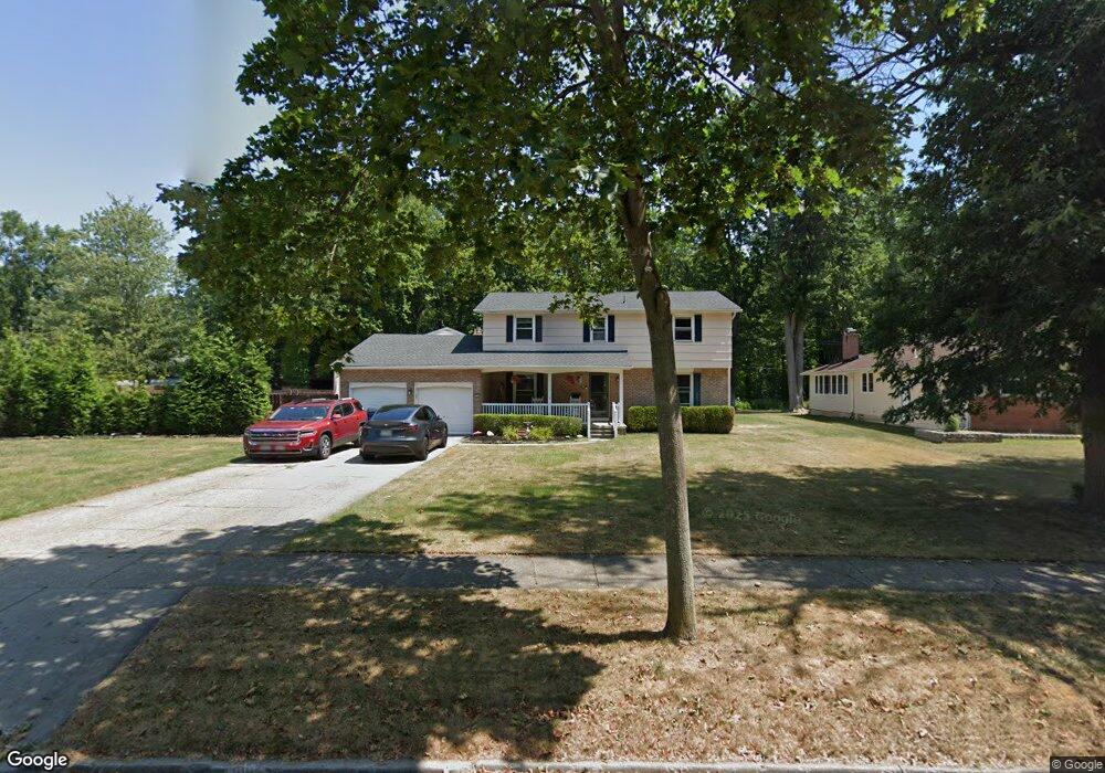
219 Cottonwood Dr Buffalo, NY 14221
South Amherst NeighborhoodEstimated Value: $438,000 - $479,000
4
Beds
3
Baths
2,156
Sq Ft
$213/Sq Ft
Est. Value
About This Home
This home is located at 219 Cottonwood Dr, Buffalo, NY 14221 and is currently estimated at $458,996, approximately $212 per square foot. 219 Cottonwood Dr is a home located in Erie County with nearby schools including Maple West Elementary School, Heim Middle School, and Williamsville North High School.
Ownership History
Date
Name
Owned For
Owner Type
Purchase Details
Closed on
Nov 1, 2006
Sold by
Oconnor Charles J and Oconnor Evelyn
Bought by
Evans John M and Evans Diane B
Current Estimated Value
Home Financials for this Owner
Home Financials are based on the most recent Mortgage that was taken out on this home.
Original Mortgage
$143,120
Outstanding Balance
$85,888
Interest Rate
6.47%
Mortgage Type
New Conventional
Estimated Equity
$373,108
Create a Home Valuation Report for This Property
The Home Valuation Report is an in-depth analysis detailing your home's value as well as a comparison with similar homes in the area
Home Values in the Area
Average Home Value in this Area
Purchase History
| Date | Buyer | Sale Price | Title Company |
|---|---|---|---|
| Evans John M | $178,900 | None Available |
Source: Public Records
Mortgage History
| Date | Status | Borrower | Loan Amount |
|---|---|---|---|
| Open | Evans John M | $143,120 | |
| Closed | Evans John M | $35,780 |
Source: Public Records
Tax History Compared to Growth
Tax History
| Year | Tax Paid | Tax Assessment Tax Assessment Total Assessment is a certain percentage of the fair market value that is determined by local assessors to be the total taxable value of land and additions on the property. | Land | Improvement |
|---|---|---|---|---|
| 2024 | $8,395 | $400,000 | $73,600 | $326,400 |
| 2023 | $7,792 | $228,000 | $43,300 | $184,700 |
| 2022 | $7,272 | $228,000 | $43,300 | $184,700 |
| 2021 | $7,131 | $228,000 | $43,300 | $184,700 |
| 2020 | $6,476 | $228,000 | $43,300 | $184,700 |
| 2019 | $6,349 | $228,000 | $43,300 | $184,700 |
| 2018 | $6,228 | $228,000 | $43,300 | $184,700 |
| 2017 | $2,769 | $228,000 | $43,300 | $184,700 |
| 2016 | $6,240 | $205,500 | $43,300 | $162,200 |
| 2015 | -- | $205,500 | $43,300 | $162,200 |
| 2014 | -- | $205,500 | $43,300 | $162,200 |
Source: Public Records
Map
Nearby Homes
- 930 Hopkins Rd Unit H
- 67 Birchwood Dr
- 158 Old Farm Cir
- 180 Crestwood Ln
- 12 Spicebush Ln Unit 12
- 42 Spicebush Ln
- 40 Spicebush Ln
- 19 Countryside Ct
- 59 Timberlane Dr
- 114 Robin Hill Dr
- 88 W Klein Rd
- 26 Village Gate Ct
- 163 Randwood Dr
- 147 Ranch Trail W
- 55 Birch Ln
- 59 Laurie Lea
- 47 Birch Ln
- 23 Birch Ln
- 100 Countryside Ln
- 85 Mahogany Dr
- 10 Cherrywood Dr
- 18 Cherrywood Dr
- 209 Cottonwood Dr
- 214 Cottonwood Dr
- 208 Cottonwood Dr
- 203 Cottonwood Dr
- 26 Cherrywood Dr
- 202 Cottonwood Dr
- 224 Cottonwood Dr
- 31 Cherrywood Dr
- 37 Cherrywood Dr
- 197 Cottonwood Dr
- 196 Cottonwood Dr
- 58 Cherrywood Dr
- 230 Cottonwood Dr
- 191 Cottonwood Dr
- 190 Cottonwood Dr
- 229 Cottonwood Dr
- 64 Cherrywood Dr
- 236 Cottonwood Dr