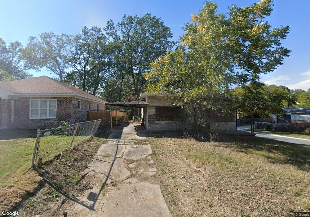
2200 Howard St Little Rock, AR 72202
Central High NeighborhoodEstimated Value: $71,794 - $109,000
--
Bed
3
Baths
1,552
Sq Ft
$57/Sq Ft
Est. Value
About This Home
This home is located at 2200 Howard St, Little Rock, AR 72202 and is currently estimated at $87,699, approximately $56 per square foot. 2200 Howard St is a home located in Pulaski County with nearby schools including Stephens Elementary School, Dunbar Magnet Middle School, and Central High School.
Ownership History
Date
Name
Owned For
Owner Type
Purchase Details
Closed on
Mar 14, 2022
Sold by
Commissioner Of State Lands
Bought by
Cdc Blight Avengers
Current Estimated Value
Purchase Details
Closed on
Dec 10, 2020
Sold by
Blight Avengers Community Dev Corp
Bought by
Lewis Scott E
Purchase Details
Closed on
Sep 12, 2016
Sold by
Reed Neill
Bought by
Home Sweet Home Rentals Llc
Purchase Details
Closed on
Mar 22, 2016
Sold by
Keith Byron
Bought by
Reed Neil
Purchase Details
Closed on
Sep 24, 2004
Sold by
Keith Michael V and Keith Byron
Bought by
Keith Byron
Create a Home Valuation Report for This Property
The Home Valuation Report is an in-depth analysis detailing your home's value as well as a comparison with similar homes in the area
Home Values in the Area
Average Home Value in this Area
Purchase History
| Date | Buyer | Sale Price | Title Company |
|---|---|---|---|
| Cdc Blight Avengers | $2,372 | None Listed On Document | |
| Lewis Scott E | -- | None Available | |
| Home Sweet Home Rentals Llc | -- | None Available | |
| Reed Neil | $400 | Attorney | |
| Keith Byron | -- | None Available | |
| Keith Michael | -- | None Available |
Source: Public Records
Tax History Compared to Growth
Tax History
| Year | Tax Paid | Tax Assessment Tax Assessment Total Assessment is a certain percentage of the fair market value that is determined by local assessors to be the total taxable value of land and additions on the property. | Land | Improvement |
|---|---|---|---|---|
| 2025 | $585 | $8,359 | $800 | $7,559 |
| 2024 | $585 | $8,359 | $800 | $7,559 |
| 2023 | $585 | $8,359 | $800 | $7,559 |
| 2022 | $585 | $8,359 | $800 | $7,559 |
| 2021 | $334 | $4,740 | $600 | $4,140 |
| 2020 | $332 | $4,740 | $600 | $4,140 |
| 2019 | $332 | $4,740 | $600 | $4,140 |
| 2018 | $332 | $4,740 | $600 | $4,140 |
| 2017 | $332 | $4,740 | $600 | $4,140 |
| 2016 | $318 | $4,540 | $1,600 | $2,940 |
| 2015 | $318 | $4,540 | $1,600 | $2,940 |
| 2014 | $318 | $4,540 | $1,600 | $2,940 |
Source: Public Records
Map
Nearby Homes
- 2220 W 22nd St
- 2213 Dennison St
- 1817 S Park St
- 2100 S Battery St
- 1921 Wright Ave
- 1905 S Battery St
- 2211 W 17th St
- 3214 Wolfe St
- 2103 Wolfe St
- 2405 S Battery St
- 1724 W 19th St
- 1910 S Woodrow St
- 1616 Dennison St
- 2600 S Battery St
- 2417 Wolfe St
- 1609 W Charles Bussey Ave
- 1623 W 24th St
- 2600 Wolfe St
- 1524 W 22nd St
- 1509 W 19th St
- 2204 Howard St
- 2122 Howard St
- 2201 Dennison St
- S Dennison St
- 2201 S Dennison St
- 2205 Dennison St
- 2206 Howard St
- 2216 W 22nd St
- 2114 Howard St
- 2201 Howard St
- 2203 Howard St
- 2218 W 22nd St
- 2123 Howard St
- 2108 Howard St
- 2207 Howard St
- 2209 Dennison St
- 2224 Howard St
- 2211 Dennison St
- 2117 Howard St
- 2105 Dennison St