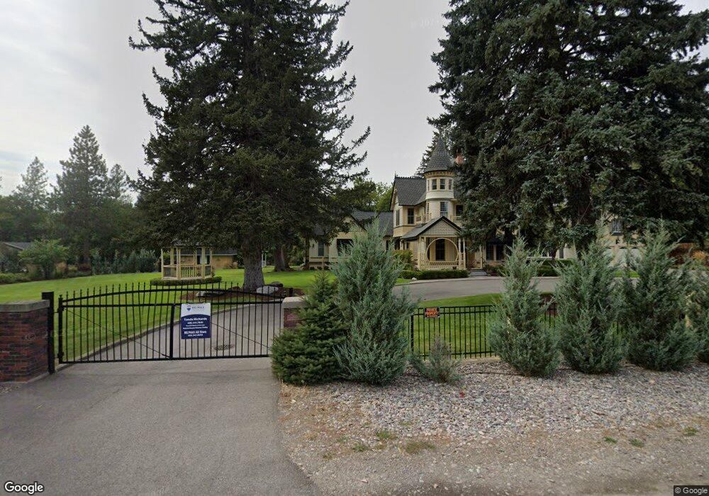
2201 Raymond Ave Missoula, MT 59802
Lower Rattlesnake NeighborhoodEstimated Value: $1,609,000 - $3,113,000
6
Beds
7
Baths
5,444
Sq Ft
$403/Sq Ft
Est. Value
About This Home
This home is located at 2201 Raymond Ave, Missoula, MT 59802 and is currently estimated at $2,192,140, approximately $402 per square foot. 2201 Raymond Ave is a home located in Missoula County with nearby schools including Rattlesnake Elementary School, Washington Middle School, and Hellgate High School.
Ownership History
Date
Name
Owned For
Owner Type
Purchase Details
Closed on
Aug 27, 2021
Sold by
Hobbs Roger C
Bought by
Gomes Robert D and Gomes Lisa L
Current Estimated Value
Home Financials for this Owner
Home Financials are based on the most recent Mortgage that was taken out on this home.
Original Mortgage
$1,180,000
Outstanding Balance
$1,072,109
Interest Rate
2.7%
Mortgage Type
VA
Estimated Equity
$1,120,031
Purchase Details
Closed on
Jun 16, 2016
Sold by
Victorian House Llc
Bought by
Hobbs Roger C
Purchase Details
Closed on
Aug 14, 2008
Sold by
Hobbs Roger C and Hobbs Kathy M
Bought by
Victorian House Llc
Create a Home Valuation Report for This Property
The Home Valuation Report is an in-depth analysis detailing your home's value as well as a comparison with similar homes in the area
Home Values in the Area
Average Home Value in this Area
Purchase History
| Date | Buyer | Sale Price | Title Company |
|---|---|---|---|
| Gomes Robert D | -- | First American Title Company | |
| Hobbs Roger C | -- | None Available | |
| Victorian House Llc | -- | None Available |
Source: Public Records
Mortgage History
| Date | Status | Borrower | Loan Amount |
|---|---|---|---|
| Open | Gomes Robert D | $1,180,000 |
Source: Public Records
Tax History Compared to Growth
Tax History
| Year | Tax Paid | Tax Assessment Tax Assessment Total Assessment is a certain percentage of the fair market value that is determined by local assessors to be the total taxable value of land and additions on the property. | Land | Improvement |
|---|---|---|---|---|
| 2025 | $20,857 | $2,942,772 | $342,552 | $2,600,220 |
| 2024 | $19,980 | $1,641,852 | $286,792 | $1,355,060 |
| 2023 | $19,288 | $1,641,852 | $286,792 | $1,355,060 |
| 2022 | $19,891 | $1,469,686 | $0 | $0 |
| 2021 | $17,490 | $1,439,776 | $0 | $0 |
| 2020 | $17,724 | $1,352,482 | $0 | $0 |
| 2019 | $18,296 | $1,732,042 | $0 | $0 |
| 2018 | $20,248 | $1,508,996 | $0 | $0 |
| 2017 | $17,256 | $1,307,236 | $0 | $0 |
| 2016 | $16,368 | $1,295,220 | $0 | $0 |
| 2015 | $15,141 | $1,295,220 | $0 | $0 |
| 2014 | $17,994 | $867,776 | $0 | $0 |
Source: Public Records
Map
Nearby Homes
- 2215 Raymond Ave
- 1227 Basecamp Dr Unit A
- 2411 Raymond Ave
- 1250 Basecamp Dr Unit C
- 1250 Basecamp Dr Unit F
- 2606 Sycamore St
- 2201 Greenough Ct W
- 1300 Dickinson St
- 521 Arbor Dr
- 1811 Elison Ln
- 1306 Lily Ct
- 1132 Jackson St
- 1625 Sunflower Dr
- 1655 Sunflower Dr
- 45 Brookside Way
- 838 Locust St
- 19 Columbine Rd
- 7 Brookside Way
- 11 Contour Rd
- 1015 Poplar St
- 2216 Raymond Ave
- 2218 Wylie Ave
- 2237 Raymond Ave
- 2161 Raymond Ave
- 2141 Raymond Ave
- 2222 Wylie Ave
- 2210 Raymond Ave
- 2202 Raymond Ave
- 2201 Wylie Ave
- 2121 Raymond Ave
- 2207 Wylie Ave
- 2235 Wylie Ave
- 2120 Wylie Ave
- 2240 Raymond Ave
- 2212 Raymond Ave
- 2250 Raymond Ave
- 1003 Laurel Ln
- 903 Lolo St
- 2246 Raymond Ave
- Lot 10 Lolo St