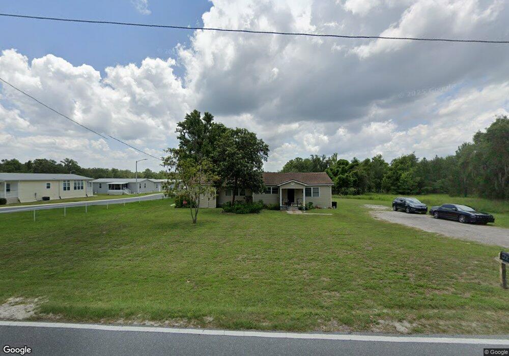
22176 Croom Rd Brooksville, FL 34601
Estimated Value: $229,000 - $333,000
3
Beds
2
Baths
1,632
Sq Ft
$162/Sq Ft
Est. Value
About This Home
This home is located at 22176 Croom Rd, Brooksville, FL 34601 and is currently estimated at $264,356, approximately $161 per square foot. 22176 Croom Rd is a home located in Hernando County with nearby schools including Brooksville Elementary School, Hernando High School, and D. S. Parrott Middle School.
Ownership History
Date
Name
Owned For
Owner Type
Purchase Details
Closed on
May 14, 2021
Sold by
Hamilto Otis Alvin and Hamilton Anna Marie
Bought by
Pillars Investments Llc
Current Estimated Value
Purchase Details
Closed on
Nov 21, 2017
Sold by
Shiflett Synchak Chela
Bought by
Hamilton Otis Alvin and Hamilton Anna Marie
Home Financials for this Owner
Home Financials are based on the most recent Mortgage that was taken out on this home.
Original Mortgage
$52,040
Interest Rate
4.99%
Mortgage Type
FHA
Purchase Details
Closed on
Oct 4, 2007
Sold by
Dail Mary A and Dail Wallace E
Bought by
Dail Mary A
Create a Home Valuation Report for This Property
The Home Valuation Report is an in-depth analysis detailing your home's value as well as a comparison with similar homes in the area
Home Values in the Area
Average Home Value in this Area
Purchase History
| Date | Buyer | Sale Price | Title Company |
|---|---|---|---|
| Pillars Investments Llc | $150,000 | Home Land Title Inc | |
| Hamilton Otis Alvin | $53,000 | Gulf Coast Title Co Inc | |
| Dail Mary A | -- | None Available |
Source: Public Records
Mortgage History
| Date | Status | Borrower | Loan Amount |
|---|---|---|---|
| Previous Owner | Hamilton Otis Alvin | $52,040 |
Source: Public Records
Tax History Compared to Growth
Tax History
| Year | Tax Paid | Tax Assessment Tax Assessment Total Assessment is a certain percentage of the fair market value that is determined by local assessors to be the total taxable value of land and additions on the property. | Land | Improvement |
|---|---|---|---|---|
| 2024 | $3,101 | $136,629 | $14,362 | $122,267 |
| 2023 | $3,101 | $133,365 | $0 | $0 |
| 2022 | $2,877 | $121,241 | $11,817 | $109,424 |
| 2021 | $628 | $60,278 | $0 | $0 |
| 2020 | $829 | $59,446 | $0 | $0 |
| 2019 | $843 | $58,109 | $0 | $0 |
| 2018 | $584 | $57,026 | $4,502 | $52,524 |
| 2017 | $1,355 | $51,469 | $5,002 | $46,467 |
| 2016 | $1,218 | $44,428 | $0 | $0 |
| 2015 | $1,157 | $42,329 | $0 | $0 |
| 2014 | $463 | $39,199 | $0 | $0 |
Source: Public Records
Map
Nearby Homes
- 5644 Woodford St Unit 5644E
- 5668 Woodford St Unit 5668E
- 5656 Woodford St Unit 5656E
- 5337 Bahia Way Unit 5337E
- 5385 Bahia Way
- 5451 Woodford St Unit 5451E
- 5456 Ryegrass Ct Unit 5456E
- 5480 Ryegrass Ct Unit 5480E
- 5331 Heron Rest Dr Unit 5331E
- 5460 Bahia Way Unit 5460EB
- 5364 Bahia Way Unit 5364E
- 4034 Colleen Ln
- 3134 Clare Ct
- 5003 Twingate Ave
- 5117 New Cross St
- 5011 Twingate Ave
- 4303 Andrew Ln Unit 4303
- 3095 Westland Rd
- 6115 Grady St
- 3056 Meetinghouse Ln
- 5576 Woodford St Unit 5576E
- 5547 Woodford St
- 5315 Bahia Way Unit 5315E
- 5610 Woodford St Unit 5610E
- 22173 Croom Rd
- 5325 Bahia Way Unit 5325E
- 5620 Woodford St Unit 5620E
- 5632 Woodford St Unit 5632E
- 5518 Woodford St Unit 5518E
- 5328 Bahia Way Unit 5328E
- 5340 Bahia Way Unit 5340E
- 5499 Woodford St
- 5499 Woodford St Unit 16
- 5506 Woodford St Unit 5506E
- 22163 Croom Rd
- 5485 Woodford St
- 5361 Bahia Way Unit 5361E
- 5447 Bahia Way Unit 5447E
- 5397 Bahia Way Unit 5397E
- 5392 Bahia Way Unit 5392E