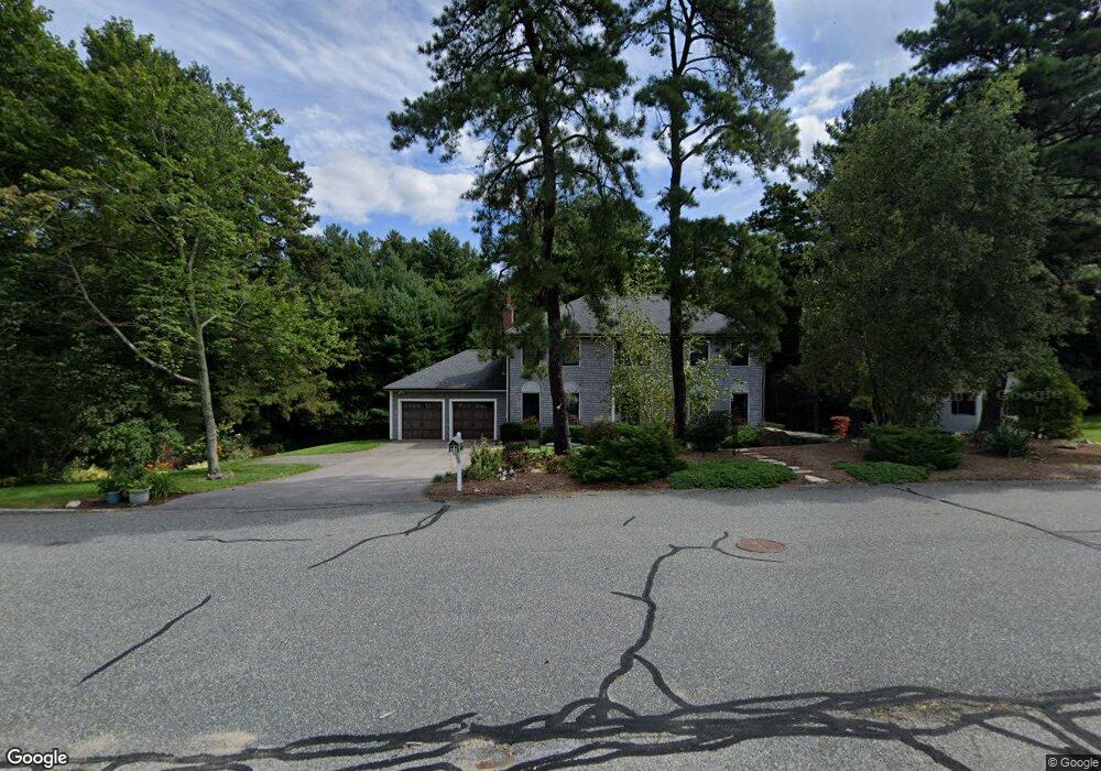
23 Byron Rd Ashland, MA 01721
Estimated Value: $934,725 - $1,055,000
3
Beds
3
Baths
2,669
Sq Ft
$368/Sq Ft
Est. Value
About This Home
This home is located at 23 Byron Rd, Ashland, MA 01721 and is currently estimated at $980,931, approximately $367 per square foot. 23 Byron Rd is a home located in Middlesex County with nearby schools including William Pittaway Elementary School, Henry E. Warren Elementary School, and David Mindess Elementary School.
Ownership History
Date
Name
Owned For
Owner Type
Purchase Details
Closed on
Oct 16, 2007
Sold by
Starer Jacquelyn J
Bought by
Green Charles F and Starer Jacquelyn J
Current Estimated Value
Purchase Details
Closed on
Mar 31, 1989
Sold by
Mele Michael
Bought by
Starer Jacquelyn J
Create a Home Valuation Report for This Property
The Home Valuation Report is an in-depth analysis detailing your home's value as well as a comparison with similar homes in the area
Home Values in the Area
Average Home Value in this Area
Purchase History
| Date | Buyer | Sale Price | Title Company |
|---|---|---|---|
| Green Charles F | -- | -- | |
| Starer Jacquelyn J | $259,900 | -- |
Source: Public Records
Mortgage History
| Date | Status | Borrower | Loan Amount |
|---|---|---|---|
| Closed | Starer Jacquelyn J | $200,000 | |
| Closed | Starer Jacquelyn J | $50,000 | |
| Closed | Starer Jacquelyn J | $180,000 |
Source: Public Records
Tax History Compared to Growth
Tax History
| Year | Tax Paid | Tax Assessment Tax Assessment Total Assessment is a certain percentage of the fair market value that is determined by local assessors to be the total taxable value of land and additions on the property. | Land | Improvement |
|---|---|---|---|---|
| 2025 | $11,153 | $873,400 | $284,100 | $589,300 |
| 2024 | $10,850 | $819,500 | $284,100 | $535,400 |
| 2023 | $10,004 | $726,500 | $270,600 | $455,900 |
| 2022 | $10,128 | $637,800 | $246,000 | $391,800 |
| 2021 | $9,636 | $604,900 | $246,000 | $358,900 |
| 2020 | $9,101 | $563,200 | $246,000 | $317,200 |
| 2019 | $14,137 | $508,600 | $246,000 | $262,600 |
| 2018 | $13,653 | $492,000 | $243,900 | $248,100 |
| 2017 | $7,958 | $476,500 | $245,100 | $231,400 |
| 2016 | $7,757 | $456,300 | $242,100 | $214,200 |
| 2015 | $7,541 | $435,900 | $230,100 | $205,800 |
| 2014 | $7,452 | $428,500 | $188,100 | $240,400 |
Source: Public Records
Map
Nearby Homes
- 1 Adams Rd
- 9 Adams Rd
- 2 Adams Rd Unit 2
- 17 Sewell St
- 67 Spyglass Hill Dr
- 23 Spyglass Hill Dr
- 83 Spyglass Hill Dr
- 306 Trailside Way
- 63 Trailside Way Unit 63
- 37 James Rd
- 88 Brush Hill Rd
- 76 Algonquin Trail
- 158 Algonquin Trail
- 102 Captain Eames Cir
- 126 Mountain Gate Rd Unit 126
- 291 Captain Eames Cir
- 379 Captain Eames Cir
- 343 Captain Eames Cir Unit 38-C
- 74 Meeting House Path
- 277 Meeting House Path