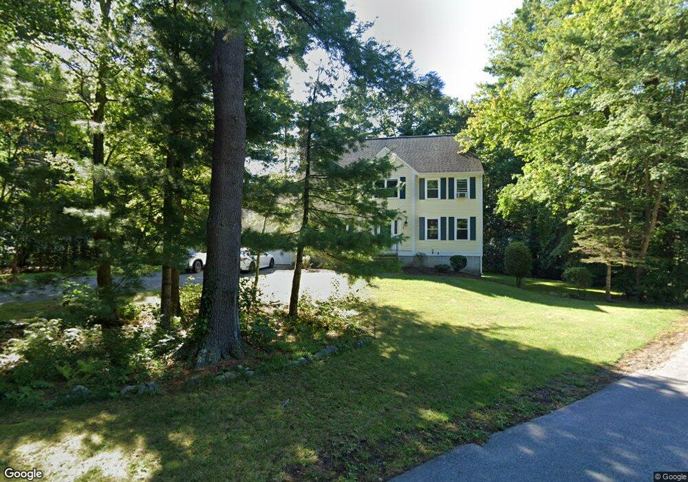
23 Kelley St Medway, MA 02053
Estimated Value: $786,008 - $936,000
4
Beds
3
Baths
2,304
Sq Ft
$380/Sq Ft
Est. Value
About This Home
This home is located at 23 Kelley St, Medway, MA 02053 and is currently estimated at $874,752, approximately $379 per square foot. 23 Kelley St is a home located in Norfolk County with nearby schools including John D. McGovern Elementary School, Burke-Memorial Elementary, and Medway Middle School.
Ownership History
Date
Name
Owned For
Owner Type
Purchase Details
Closed on
Mar 26, 2024
Sold by
Mchugh William P and Mchugh Kristen M
Bought by
Mchigh Ft and Mchugh
Current Estimated Value
Purchase Details
Closed on
Aug 21, 1995
Sold by
Drew Leo R and Drew Elizabeth
Bought by
Mcelligott Brian T and Mcelligott Jennifer Lw
Home Financials for this Owner
Home Financials are based on the most recent Mortgage that was taken out on this home.
Original Mortgage
$138,000
Interest Rate
7.61%
Mortgage Type
Purchase Money Mortgage
Create a Home Valuation Report for This Property
The Home Valuation Report is an in-depth analysis detailing your home's value as well as a comparison with similar homes in the area
Home Values in the Area
Average Home Value in this Area
Purchase History
| Date | Buyer | Sale Price | Title Company |
|---|---|---|---|
| Mchigh Ft | -- | None Available | |
| Mcelligott Brian T | $238,000 | -- | |
| Mcelligott Brian T | $238,000 | -- |
Source: Public Records
Mortgage History
| Date | Status | Borrower | Loan Amount |
|---|---|---|---|
| Previous Owner | Mcelligott Brian T | $138,000 | |
| Previous Owner | Mcelligott Brian T | $138,000 |
Source: Public Records
Tax History Compared to Growth
Tax History
| Year | Tax Paid | Tax Assessment Tax Assessment Total Assessment is a certain percentage of the fair market value that is determined by local assessors to be the total taxable value of land and additions on the property. | Land | Improvement |
|---|---|---|---|---|
| 2025 | $9,684 | $679,600 | $325,900 | $353,700 |
| 2024 | $9,786 | $679,600 | $325,900 | $353,700 |
| 2023 | $9,719 | $609,700 | $296,600 | $313,100 |
| 2022 | $8,539 | $504,400 | $219,300 | $285,100 |
| 2021 | $8,302 | $475,500 | $204,700 | $270,800 |
| 2020 | $8,138 | $465,000 | $204,700 | $260,300 |
| 2019 | $7,681 | $452,600 | $196,400 | $256,200 |
| 2018 | $7,733 | $437,900 | $188,000 | $249,900 |
| 2017 | $7,698 | $429,600 | $183,800 | $245,800 |
| 2016 | $7,516 | $415,000 | $169,200 | $245,800 |
| 2015 | $7,455 | $408,700 | $167,100 | $241,600 |
| 2014 | $7,645 | $405,800 | $167,100 | $238,700 |
Source: Public Records
Map
Nearby Homes
- 22 Sunset Dr
- 280 Village St Unit D2
- 4 Shaw St
- 3 Meryl St
- 14 Heritage Dr
- 12 Lovering St
- 106 Holliston St
- 36 Lovering St
- 28 Wellington St
- 50 Main St
- 176 Main St Unit 3
- 20 Broad St Unit 6
- 20 Broad St Unit A
- 20 Broad St Unit 4
- 14 Sanford St Unit 15
- 9 Sanford St
- 21 Riverside Rd
- 220 Main St Unit 220
- 5 Fales St
- 0 Elm St