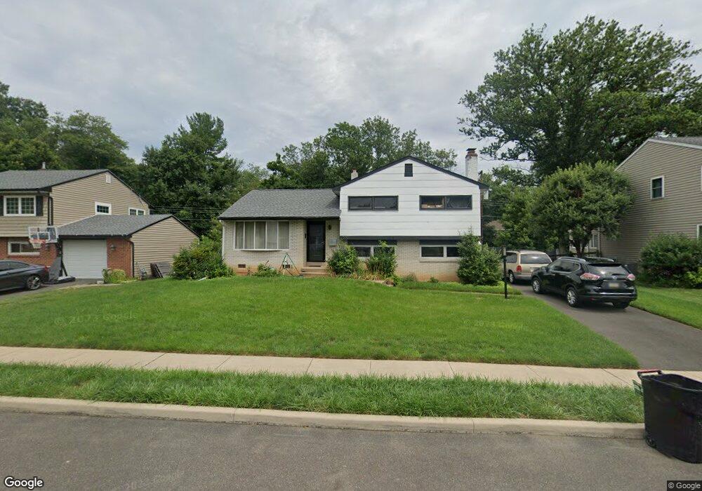
230 Louise Dr Morrisville, PA 19067
Estimated Value: $388,000 - $504,000
3
Beds
2
Baths
1,206
Sq Ft
$378/Sq Ft
Est. Value
About This Home
This home is located at 230 Louise Dr, Morrisville, PA 19067 and is currently estimated at $456,013, approximately $378 per square foot. 230 Louise Dr is a home located in Bucks County with nearby schools including Eleanor Roosevelt Elementary School, Pennwood Middle School, and Pennsbury High School.
Ownership History
Date
Name
Owned For
Owner Type
Purchase Details
Closed on
Jun 3, 2020
Sold by
Kilkuskie Theodore F and Estate Of Theodore F Kilkuskie
Bought by
Kilkuskie Kristen M
Current Estimated Value
Home Financials for this Owner
Home Financials are based on the most recent Mortgage that was taken out on this home.
Original Mortgage
$240,562
Outstanding Balance
$213,240
Interest Rate
3.2%
Mortgage Type
FHA
Estimated Equity
$242,773
Purchase Details
Closed on
Jul 28, 1959
Bought by
Kilkuskie Theo F and Kilkuskie Yolanda
Create a Home Valuation Report for This Property
The Home Valuation Report is an in-depth analysis detailing your home's value as well as a comparison with similar homes in the area
Home Values in the Area
Average Home Value in this Area
Purchase History
| Date | Buyer | Sale Price | Title Company |
|---|---|---|---|
| Kilkuskie Kristen M | $245,000 | All Service Abstract Inc | |
| Kilkuskie Theo F | -- | -- |
Source: Public Records
Mortgage History
| Date | Status | Borrower | Loan Amount |
|---|---|---|---|
| Open | Kilkuskie Kristen M | $240,562 |
Source: Public Records
Tax History Compared to Growth
Tax History
| Year | Tax Paid | Tax Assessment Tax Assessment Total Assessment is a certain percentage of the fair market value that is determined by local assessors to be the total taxable value of land and additions on the property. | Land | Improvement |
|---|---|---|---|---|
| 2025 | $5,790 | $26,000 | $5,280 | $20,720 |
| 2024 | $5,790 | $26,000 | $5,280 | $20,720 |
| 2023 | $5,548 | $26,000 | $5,280 | $20,720 |
| 2022 | $5,375 | $26,000 | $5,280 | $20,720 |
| 2021 | $5,271 | $26,000 | $5,280 | $20,720 |
| 2020 | $5,271 | $26,000 | $5,280 | $20,720 |
| 2019 | $5,179 | $26,000 | $5,280 | $20,720 |
| 2018 | $5,115 | $26,000 | $5,280 | $20,720 |
| 2017 | $4,986 | $26,000 | $5,280 | $20,720 |
| 2016 | $4,986 | $26,000 | $5,280 | $20,720 |
| 2015 | $4,547 | $26,000 | $5,280 | $20,720 |
| 2014 | $4,547 | $26,000 | $5,280 | $20,720 |
Source: Public Records
Map
Nearby Homes
- 211 Valley Rd
- 404 Alden Ave
- 413 Alden Ave
- 5 Patrick Ln
- 209 Alden Ave
- 113 Penns Grant Dr
- 494 Keating Dr
- 581 Nottingham Dr
- 79 Sutphin Pines
- 96 Sutphin Pines
- 229 Walton Dr
- 51 Sutphin Pines
- 5 Sutphin Pines
- 227 W Ferry Rd
- 1306 Moon Dr
- 5 Fayette Dr
- 1706 Makefield Rd
- 688 Carlisle Dr
- 20 S Homestead Dr
- 1517 Derbyshire Rd