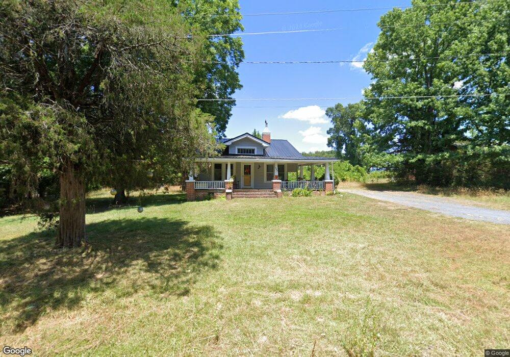
232 Southway Rd Asheboro, NC 27205
Estimated Value: $161,110 - $202,000
2
Beds
1
Bath
1,268
Sq Ft
$140/Sq Ft
Est. Value
About This Home
This home is located at 232 Southway Rd, Asheboro, NC 27205 and is currently estimated at $177,528, approximately $140 per square foot. 232 Southway Rd is a home located in Randolph County with nearby schools including Charles W. McCrary Elementary School, North Asheboro Middle School, and Asheboro High School.
Ownership History
Date
Name
Owned For
Owner Type
Purchase Details
Closed on
Apr 16, 2021
Sold by
Substitute Trustee Services Inc
Bought by
Mahan Properties Llc
Current Estimated Value
Purchase Details
Closed on
Jun 9, 2010
Sold by
Stroud Larry Randall and Restrepo Ana
Bought by
Wood Daniel V
Home Financials for this Owner
Home Financials are based on the most recent Mortgage that was taken out on this home.
Original Mortgage
$64,037
Interest Rate
4.97%
Mortgage Type
FHA
Purchase Details
Closed on
Apr 17, 2003
Bought by
Wood Daniel Vance Heirs
Purchase Details
Closed on
Jun 28, 2002
Bought by
Wood Daniel Vance Heirs
Create a Home Valuation Report for This Property
The Home Valuation Report is an in-depth analysis detailing your home's value as well as a comparison with similar homes in the area
Home Values in the Area
Average Home Value in this Area
Purchase History
| Date | Buyer | Sale Price | Title Company |
|---|---|---|---|
| Mahan Properties Llc | -- | None Listed On Document | |
| Wood Daniel V | $65,000 | None Available | |
| Wood Daniel Vance Heirs | $79,500 | -- | |
| Wood Daniel Vance Heirs | $80,500 | -- |
Source: Public Records
Mortgage History
| Date | Status | Borrower | Loan Amount |
|---|---|---|---|
| Previous Owner | Wood Daniel V | $64,037 |
Source: Public Records
Tax History Compared to Growth
Tax History
| Year | Tax Paid | Tax Assessment Tax Assessment Total Assessment is a certain percentage of the fair market value that is determined by local assessors to be the total taxable value of land and additions on the property. | Land | Improvement |
|---|---|---|---|---|
| 2025 | $1,555 | $117,350 | $24,700 | $92,650 |
| 2024 | $1,555 | $117,350 | $24,700 | $92,650 |
| 2023 | $1,555 | $117,350 | $24,700 | $92,650 |
| 2022 | $1,179 | $81,810 | $18,280 | $63,530 |
| 2021 | $1,179 | $81,810 | $18,280 | $63,530 |
| 2020 | $1,179 | $81,810 | $18,280 | $63,530 |
| 2019 | $1,179 | $81,810 | $18,280 | $63,530 |
| 2018 | $1,059 | $72,160 | $21,720 | $50,440 |
| 2016 | $1,059 | $72,159 | $21,720 | $50,439 |
| 2015 | $1,061 | $72,159 | $21,720 | $50,439 |
| 2014 | $1,035 | $72,159 | $21,720 | $50,439 |
Source: Public Records
Map
Nearby Homes
- 923 Arnold St
- 1263 Winslow Ave Unit A, B & C
- 135 West St
- 627 Oakmont Dr
- 830 Sunset Ave
- 435 Peachtree St
- 516 and 518 Peachtree St
- 711 Sunset Ave Unit E
- 612 Sunset Ave Unit 6
- 866 Mountain Rd
- 1110 Park Dr
- TBD Oakland Ave
- 0000 Little Gate Dr
- 135 Dixon St
- 401 Uwharrie St
- 0 Highwood Dr
- 330 W Presnell St Unit 37
- 1011 Westmont Dr
- 1582 Westmont Dr
- 330 13 W Presnell St
- 238 Southway Rd
- 226 Southway Rd
- 1137 Timbal Ct
- 300 Southway Rd
- 1131 Timbal Ct
- 320 Cannon Ct
- 326 Cannon Ct
- 334 Cannon Ct
- 314 Cannon Ct
- 340 Cannon Ct
- 1164 Lexington Commons Dr
- 1162 Lexington Commons Dr
- 308 Cannon Ct
- 1156 Lexington Commons Dr
- 1125 Timbal Ct
- 402 Southway Rd
- 1150 Lexington Commons Dr
- 323 Cannon Ct
- 317 Cannon Ct
- 333 Cannon Ct