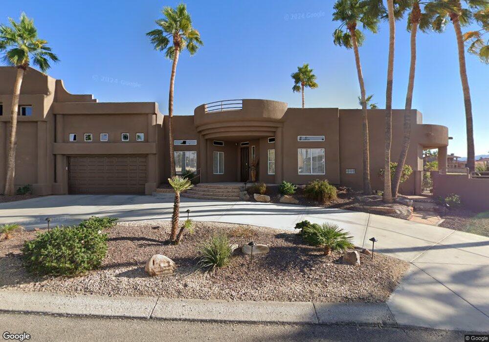
2330 Green Dr Lake Havasu City, AZ 86406
Estimated Value: $1,044,548 - $1,983,000
2
Beds
3
Baths
3,127
Sq Ft
$448/Sq Ft
Est. Value
About This Home
This home is located at 2330 Green Dr, Lake Havasu City, AZ 86406 and is currently estimated at $1,401,637, approximately $448 per square foot. 2330 Green Dr is a home located in Mohave County with nearby schools including Starline Elementary School, Thunderbolt Middle School, and Lake Havasu High School.
Ownership History
Date
Name
Owned For
Owner Type
Purchase Details
Closed on
Jun 4, 2015
Sold by
Root William F
Bought by
Robinson Darrell W and Robinson Teresa A
Current Estimated Value
Home Financials for this Owner
Home Financials are based on the most recent Mortgage that was taken out on this home.
Original Mortgage
$417,000
Outstanding Balance
$321,472
Interest Rate
3.62%
Mortgage Type
New Conventional
Estimated Equity
$1,080,165
Purchase Details
Closed on
Oct 18, 2012
Sold by
Root William F
Bought by
Root William F
Purchase Details
Closed on
Aug 17, 2011
Sold by
Willis Dean C
Bought by
Root William F
Purchase Details
Closed on
Feb 24, 2010
Sold by
Willis Dean C
Bought by
Willis Dean C
Purchase Details
Closed on
Oct 17, 2006
Sold by
Willis Dean C
Bought by
Willis Dean C
Create a Home Valuation Report for This Property
The Home Valuation Report is an in-depth analysis detailing your home's value as well as a comparison with similar homes in the area
Home Values in the Area
Average Home Value in this Area
Purchase History
| Date | Buyer | Sale Price | Title Company |
|---|---|---|---|
| Robinson Darrell W | $525,000 | Pioneer Title Agency Inc | |
| Root William F | -- | Accommodation | |
| Root William F | $600,000 | Pioneer Title Agency Inc | |
| Willis Dean C | -- | None Available | |
| Willis Dean C | -- | None Available |
Source: Public Records
Mortgage History
| Date | Status | Borrower | Loan Amount |
|---|---|---|---|
| Open | Robinson Darrell W | $417,000 |
Source: Public Records
Tax History Compared to Growth
Tax History
| Year | Tax Paid | Tax Assessment Tax Assessment Total Assessment is a certain percentage of the fair market value that is determined by local assessors to be the total taxable value of land and additions on the property. | Land | Improvement |
|---|---|---|---|---|
| 2026 | $2,441 | -- | -- | -- |
| 2025 | $4,948 | $94,077 | $0 | $0 |
| 2024 | $4,948 | $100,347 | $0 | $0 |
| 2023 | $4,948 | $87,954 | $0 | $0 |
| 2022 | $4,735 | $82,340 | $0 | $0 |
| 2021 | $4,976 | $56,161 | $0 | $0 |
| 2019 | $4,715 | $53,619 | $0 | $0 |
| 2018 | $3,947 | $51,218 | $0 | $0 |
| 2017 | $3,901 | $50,921 | $0 | $0 |
| 2016 | $3,454 | $45,333 | $0 | $0 |
| 2015 | $3,274 | $39,795 | $0 | $0 |
Source: Public Records
Map
Nearby Homes
- 2371 Stroke Dr
- 2475 Saratoga Ave
- 2480 Stroke
- 2480 Castaway Dr
- 420 Acoma Blvd S Unit 26
- 420 Acoma Blvd S Unit 25
- 2295 Daytona Loop
- 470 Acoma Blvd S Unit 128
- 470 Acoma Blvd S Unit 109
- 470 Acoma Blvd S Unit 122
- 111 Bunker Dr
- 2450 Daytona Ave
- 2530 Plaza Hermosa
- 2595 Saratoga Ave
- 2405 Wood Ln
- 2288 Casper Ln
- 2207 Oliver Ln
- 2175 Snead Dr Unit 4
- 209 Snead Dr
- 2190 Snead Dr