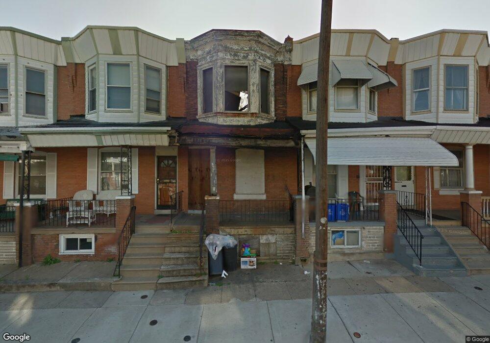
239 N Paxon St Philadelphia, PA 19139
Dunlap NeighborhoodEstimated Value: $48,000 - $50,000
3
Beds
1
Bath
--
Sq Ft
1,002
Sq Ft Lot
About This Home
This home is located at 239 N Paxon St, Philadelphia, PA 19139 and is currently estimated at $49,000. 239 N Paxon St is a home located in Philadelphia County with nearby schools including Sherman Elementary School, Union Mill Elementary School, and James Rhoads Elementary School.
Ownership History
Date
Name
Owned For
Owner Type
Purchase Details
Closed on
Sep 4, 2024
Sold by
Philadelphia Land Bank
Bought by
Mangrum Bonnie
Current Estimated Value
Home Financials for this Owner
Home Financials are based on the most recent Mortgage that was taken out on this home.
Original Mortgage
$49,999
Outstanding Balance
$49,423
Interest Rate
6.78%
Mortgage Type
Seller Take Back
Estimated Equity
-$423
Purchase Details
Closed on
May 7, 2024
Sold by
Philadelphia Redev Authority
Bought by
Philadelphia Land Bank
Purchase Details
Closed on
Apr 5, 2024
Sold by
Department Of Public Property
Bought by
Philadelphia Redev Authority
Purchase Details
Closed on
Nov 27, 1991
Bought by
City Of Phila
Create a Home Valuation Report for This Property
The Home Valuation Report is an in-depth analysis detailing your home's value as well as a comparison with similar homes in the area
Home Values in the Area
Average Home Value in this Area
Purchase History
| Date | Buyer | Sale Price | Title Company |
|---|---|---|---|
| Mangrum Bonnie | $50,000 | None Listed On Document | |
| Philadelphia Land Bank | -- | None Listed On Document | |
| Philadelphia Redev Authority | -- | None Listed On Document | |
| City Of Phila | $800 | -- |
Source: Public Records
Mortgage History
| Date | Status | Borrower | Loan Amount |
|---|---|---|---|
| Open | Mangrum Bonnie | $49,999 |
Source: Public Records
Tax History Compared to Growth
Tax History
| Year | Tax Paid | Tax Assessment Tax Assessment Total Assessment is a certain percentage of the fair market value that is determined by local assessors to be the total taxable value of land and additions on the property. | Land | Improvement |
|---|---|---|---|---|
| 2026 | -- | $22,600 | $22,600 | -- |
| 2025 | -- | $22,600 | $22,600 | -- |
| 2024 | -- | $22,600 | $22,600 | -- |
| 2023 | -- | $22,100 | $22,100 | -- |
| 2022 | $0 | $22,100 | $0 | $0 |
| 2021 | $683 | $6,900 | $6,900 | $0 |
| 2020 | $683 | $0 | $0 | $0 |
| 2019 | $683 | $0 | $0 | $0 |
| 2018 | $683 | $0 | $0 | $0 |
| 2017 | -- | $0 | $0 | $0 |
| 2016 | -- | $0 | $0 | $0 |
| 2015 | -- | $0 | $0 | $0 |
| 2014 | -- | $40,500 | $4,933 | $35,567 |
| 2012 | -- | $1,600 | $334 | $1,266 |
Source: Public Records
Map
Nearby Homes
- 241 N Paxon St
- 5144 Haverford Ave
- 5146 Haverford Ave
- 21 N Dearborn St
- 23 N Dearborn St
- 52 N Dearborn St
- 448 N Dearborn St
- 44 Farson St
- 453 Farson St
- 5216 Race St
- 138 N Dearborn St
- 5125 Brown St
- 248 N Wilton St
- 1666 N Lindenwood St
- 5055 Brown St
- 5001 Funston St
- 465 N Farson St
- 5121 Funston St
- 419 N 50th St
- 141 N Lindenwood St