Estimated Value: $453,120 - $478,000
4
Beds
3
Baths
1,909
Sq Ft
$244/Sq Ft
Est. Value
About This Home
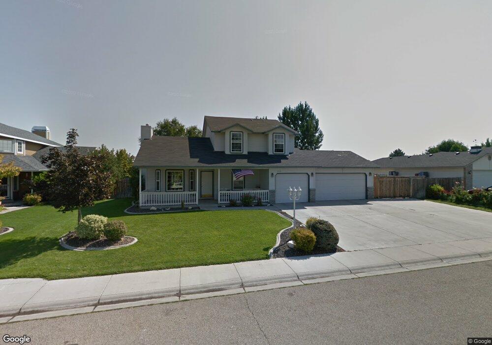
This home is located at 2426 Sierra Dr, Nampa, ID 83686 and is currently estimated at $466,030, approximately $244 per square foot. 2426 Sierra Dr is a home located in Canyon County with nearby schools including Greenhurst Elementary School, South Middle School, and Skyview High School.
Ownership History
Date
Name
Owned For
Owner Type
Purchase Details
Closed on
Feb 13, 2006
Sold by
Wolfe William A and Wolfe Sandra K
Bought by
Cedergren Darryl R and Cedergren Deborah L
Current Estimated Value
Home Financials for this Owner
Home Financials are based on the most recent Mortgage that was taken out on this home.
Original Mortgage
$160,000
Outstanding Balance
$90,074
Interest Rate
6.2%
Mortgage Type
Fannie Mae Freddie Mac
Estimated Equity
$375,956
Create a Home Valuation Report for This Property
The Home Valuation Report is an in-depth analysis detailing your home's value as well as a comparison with similar homes in the area
Home Values in the Area
Average Home Value in this Area
Purchase History
| Date | Buyer | Sale Price | Title Company |
|---|---|---|---|
| Cedergren Darryl R | -- | Stewart Title Nampa |
Source: Public Records
Mortgage History
| Date | Status | Borrower | Loan Amount |
|---|---|---|---|
| Open | Cedergren Darryl R | $160,000 |
Source: Public Records
Tax History Compared to Growth
Tax History
| Year | Tax Paid | Tax Assessment Tax Assessment Total Assessment is a certain percentage of the fair market value that is determined by local assessors to be the total taxable value of land and additions on the property. | Land | Improvement |
|---|---|---|---|---|
| 2025 | $1,745 | $430,500 | $144,700 | $285,800 |
| 2024 | $1,745 | $406,800 | $132,000 | $274,800 |
| 2023 | $1,825 | $432,200 | $132,000 | $300,200 |
| 2022 | $2,483 | $461,400 | $144,700 | $316,700 |
| 2021 | $2,169 | $309,100 | $69,000 | $240,100 |
| 2020 | $2,130 | $264,500 | $55,000 | $209,500 |
| 2019 | $2,452 | $252,800 | $55,000 | $197,800 |
| 2018 | $2,034 | $0 | $0 | $0 |
| 2017 | $1,782 | $0 | $0 | $0 |
| 2016 | $1,676 | $0 | $0 | $0 |
| 2015 | $1,572 | $0 | $0 | $0 |
| 2014 | $1,609 | $165,100 | $28,000 | $137,100 |
Source: Public Records
Map
Nearby Homes
- 2714 S Almond Ct
- 946 S Almond Ct
- 945 S Almond Ct
- 1612 E York Ave
- 1921 E Explorer Ct
- 2019 Kentucky Dr
- 1835 E Kentucky Ave
- 2622 Boulder Ave
- 2020 E Lost River Ave
- 2121 Lambert Dr
- 1801 E Iowa Ave
- 1515 Primrose Dr
- 1426 Chicago St
- 3601 S Angel Falls Way
- 2040 W Ibis Dr
- 3630 S Angel Falls Way
- 7232 E Merlin Hawk Ct
- 11623 W Black Dog Dr
- 1157 S Powerline Rd
- 2912 E Iowa Ave
- 2418 Sierra Dr
- 2502 Sierra Dr
- 2501 Wagon Wheel Rd
- 2412 Sierra Dr
- 2508 Sierra Dr
- 2427 Sierra Dr
- 2510 San Marco Way
- 2415 Wagon Wheel Rd
- 2419 Sierra Dr
- 2516 San Marco Way
- 2404 Sierra Dr
- 2521 Wagon Wheel Rd
- 2411 Sierra Dr
- 2405 Sierra Dr
- 2328 Sierra Dr
- 2524 San Marco Way
- 2511 San Marco Way
- 2428 S Meyer St
- 2605 Wagon Wheel Rd
- 2323 Wagon Wheel Rd