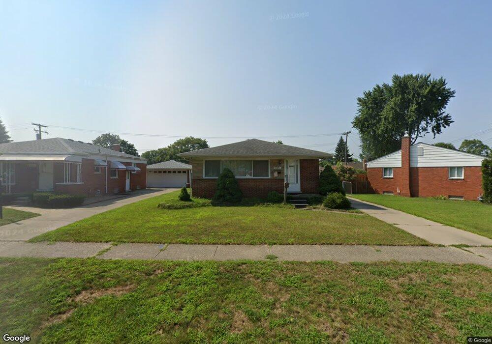
24931 Powers Ave Dearborn Heights, MI 48125
Estimated Value: $170,495 - $186,000
3
Beds
2
Baths
1,001
Sq Ft
$176/Sq Ft
Est. Value
About This Home
This home is located at 24931 Powers Ave, Dearborn Heights, MI 48125 and is currently estimated at $176,124, approximately $175 per square foot. 24931 Powers Ave is a home located in Wayne County with nearby schools including West Village Academy and Quest Charter Academy.
Ownership History
Date
Name
Owned For
Owner Type
Purchase Details
Closed on
Feb 12, 2007
Sold by
Chen Guo Hua
Bought by
Chen Guo Hua
Current Estimated Value
Purchase Details
Closed on
Jan 8, 2007
Sold by
Scott Maria M and Scott Charles
Bought by
Chen Guo Hua
Purchase Details
Closed on
Oct 25, 2006
Sold by
Scott Maria M
Bought by
Ohio Savings Bank
Purchase Details
Closed on
Jun 29, 2004
Sold by
Scott Maria M
Bought by
Scott Charles
Create a Home Valuation Report for This Property
The Home Valuation Report is an in-depth analysis detailing your home's value as well as a comparison with similar homes in the area
Home Values in the Area
Average Home Value in this Area
Purchase History
| Date | Buyer | Sale Price | Title Company |
|---|---|---|---|
| Chen Guo Hua | -- | None Available | |
| Chen Guo Hua | $124,900 | Multiple | |
| Ohio Savings Bank | $115,035 | None Available | |
| Scott Charles | -- | Multiple | |
| Scott Maria M | $139,250 | Multiple |
Source: Public Records
Tax History Compared to Growth
Tax History
| Year | Tax Paid | Tax Assessment Tax Assessment Total Assessment is a certain percentage of the fair market value that is determined by local assessors to be the total taxable value of land and additions on the property. | Land | Improvement |
|---|---|---|---|---|
| 2025 | $1,467 | $79,200 | $0 | $0 |
| 2024 | $1,467 | $72,700 | $0 | $0 |
| 2023 | $1,317 | $63,200 | $0 | $0 |
| 2022 | $1,786 | $54,300 | $0 | $0 |
| 2021 | $1,788 | $46,500 | $0 | $0 |
| 2019 | $1,630 | $37,200 | $0 | $0 |
| 2018 | $1,141 | $33,700 | $0 | $0 |
| 2017 | $894 | $33,600 | $0 | $0 |
| 2016 | $1,550 | $34,200 | $0 | $0 |
| 2015 | $3,200 | $32,000 | $0 | $0 |
| 2013 | $3,360 | $34,400 | $0 | $0 |
| 2010 | -- | $43,500 | $0 | $0 |
Source: Public Records
Map
Nearby Homes
- 4856 Carolee Ln
- 5118 Michael St
- 24443 Powers Ave
- 24754 Annapolis St
- 24360 Pennie St
- 24727 Hopkins St
- 24339 Eton Ave
- 25474 McDonald St
- 5963 Vivian St
- 25628 Powers Ave
- 25243 Lehigh St
- 6020 Vivian St
- 25118 Lehigh St
- 25212 Lehigh St
- 24117 Eton Ave
- 5842 Janet St
- 4147 Westlake St
- 24635 Stanford St
- 24035 Currier St
- 6055 Bailey St
- 24915 Powers Ave
- 24923 Powers Ave
- 24951 Powers Ave
- 24903 Powers Ave
- 25062 Currier St
- 25050 Currier St
- 25074 Currier St
- 25038 Currier St
- 24924 Powers Ave
- 24932 Powers Ave
- 24916 Powers Ave
- 24940 Powers Ave
- 25026 Currier St
- 25014 Currier St
- 24863 Powers Ave
- 5190 Westlake St
- 24972 Powers Ave
- 24948 Powers Ave
- 24980 Powers Ave
- 24851 Powers Ave