Estimated Value: $783,503 - $1,126,000
3
Beds
3
Baths
1,402
Sq Ft
$669/Sq Ft
Est. Value
About This Home
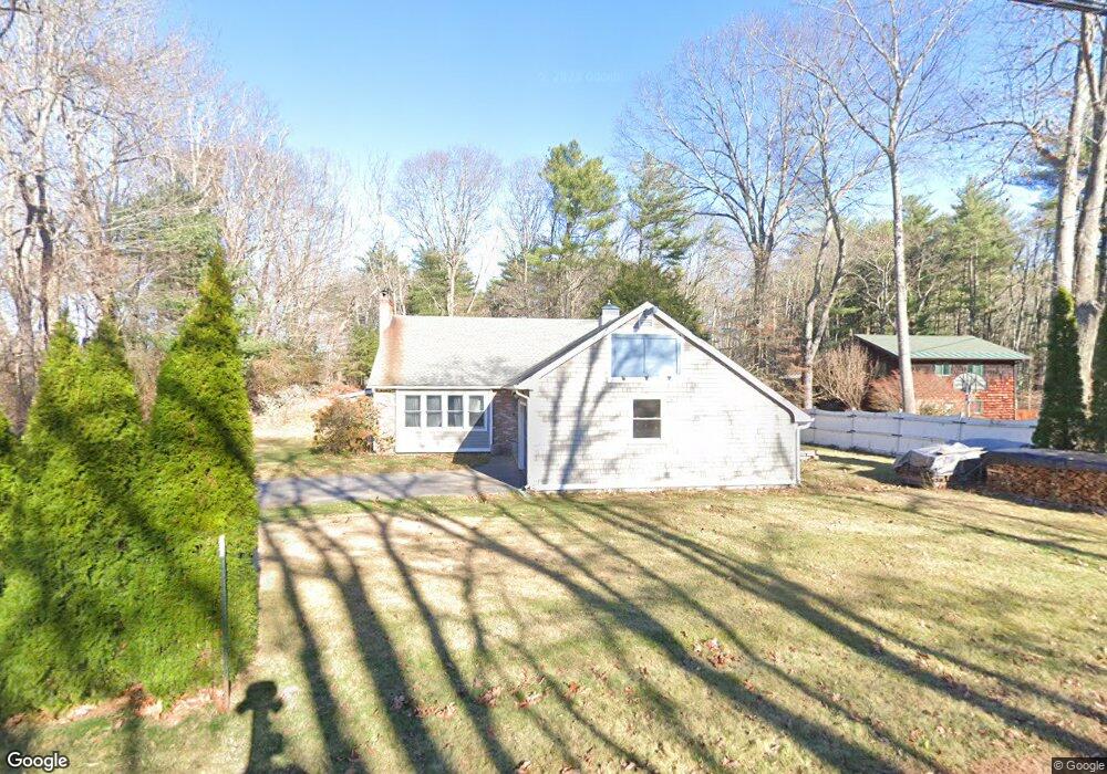
This home is located at 25 Acorn Acres, Rye, NH 03870 and is currently estimated at $938,126, approximately $669 per square foot. 25 Acorn Acres is a home located in Rockingham County with nearby schools including Rye Elementary School, Rye Junior High School, and Rye Country Day School.
Ownership History
Date
Name
Owned For
Owner Type
Purchase Details
Closed on
Aug 25, 2003
Sold by
Powers Andrew T
Bought by
Dietz Darryl H
Current Estimated Value
Home Financials for this Owner
Home Financials are based on the most recent Mortgage that was taken out on this home.
Original Mortgage
$296,000
Interest Rate
5.52%
Mortgage Type
Purchase Money Mortgage
Purchase Details
Closed on
May 2, 1997
Sold by
Tarbell William P
Bought by
Powers Andrew T
Home Financials for this Owner
Home Financials are based on the most recent Mortgage that was taken out on this home.
Original Mortgage
$159,200
Interest Rate
7.85%
Mortgage Type
Purchase Money Mortgage
Create a Home Valuation Report for This Property
The Home Valuation Report is an in-depth analysis detailing your home's value as well as a comparison with similar homes in the area
Home Values in the Area
Average Home Value in this Area
Purchase History
| Date | Buyer | Sale Price | Title Company |
|---|---|---|---|
| Dietz Darryl H | $370,000 | -- | |
| Powers Andrew T | $176,900 | -- |
Source: Public Records
Mortgage History
| Date | Status | Borrower | Loan Amount |
|---|---|---|---|
| Open | Powers Andrew T | $264,000 | |
| Closed | Powers Andrew T | $274,000 | |
| Closed | Powers Andrew T | $296,000 | |
| Previous Owner | Powers Andrew T | $159,200 |
Source: Public Records
Tax History Compared to Growth
Tax History
| Year | Tax Paid | Tax Assessment Tax Assessment Total Assessment is a certain percentage of the fair market value that is determined by local assessors to be the total taxable value of land and additions on the property. | Land | Improvement |
|---|---|---|---|---|
| 2024 | $5,122 | $591,400 | $412,600 | $178,800 |
| 2023 | $4,749 | $591,400 | $412,600 | $178,800 |
| 2022 | $4,128 | $591,400 | $412,600 | $178,800 |
| 2021 | $3,680 | $360,100 | $203,000 | $157,100 |
| 2020 | $6,453 | $360,100 | $203,000 | $157,100 |
| 2019 | $3,680 | $360,100 | $203,000 | $157,100 |
| 2018 | $5,860 | $360,100 | $203,000 | $157,100 |
| 2017 | $3,641 | $360,100 | $203,000 | $157,100 |
| 2016 | $3,468 | $324,700 | $184,500 | $140,200 |
| 2013 | $3,562 | $324,700 | $184,500 | $140,200 |
Source: Public Records
Map
Nearby Homes
- 665 Wallis Rd
- 665 Wallis Rd Unit 1
- 665 Wallis Rd Unit 2
- 37 Central Rd
- 480 Sagamore Rd
- 310 Springbrook Cir
- 916 Springbrook Cir
- 703 Springbrook Cir
- 801 Springbrook Cir
- 809 Springbrook Cir
- 389 Sagamore Rd
- 45 F w Hartford Dr
- 1643 Ocean Blvd
- 137 Clark Rd
- 1191 - 1193 Ocean Blvd
- 1 Pheasant Ln
- 204 Mackerel Ave
- 103 Bluefish Blvd
- 315 Salmon Ave
- 115 Bluefish Blvd