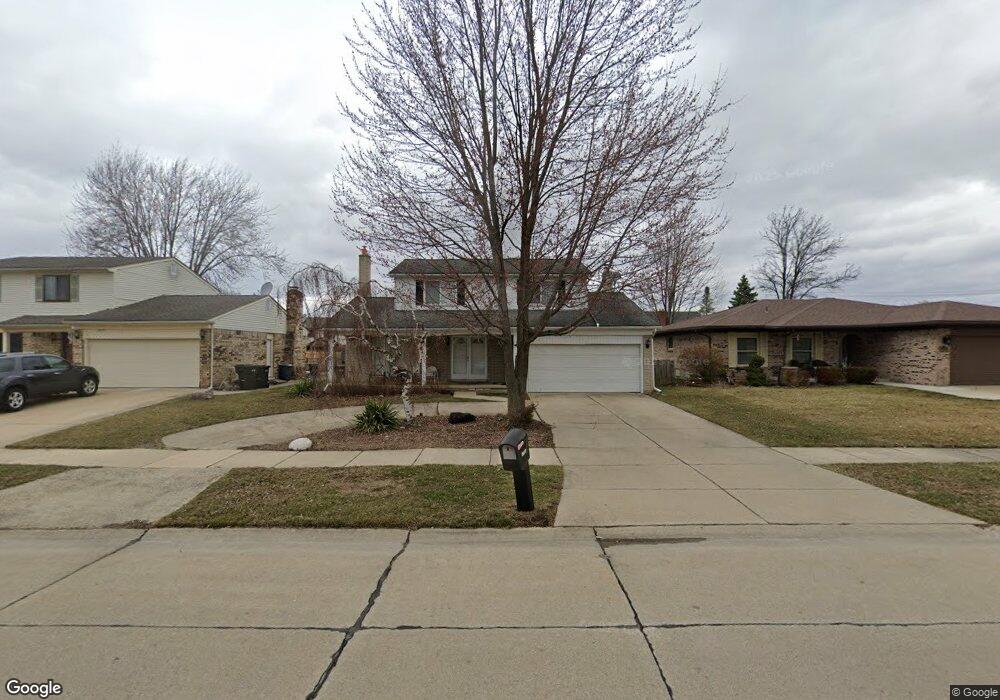
2555 Franklin Park Dr Sterling Heights, MI 48310
Estimated Value: $307,239 - $385,000
--
Bed
1
Bath
1,742
Sq Ft
$207/Sq Ft
Est. Value
About This Home
This home is located at 2555 Franklin Park Dr, Sterling Heights, MI 48310 and is currently estimated at $360,310, approximately $206 per square foot. 2555 Franklin Park Dr is a home located in Macomb County with nearby schools including Schuchard Elementary School, Frank Jeannette Junior High School, and Adlai Stevenson High School.
Ownership History
Date
Name
Owned For
Owner Type
Purchase Details
Closed on
Mar 18, 2024
Sold by
Detmer James M and Kaleta Irene S
Bought by
Detmer James M and Kaleta Irene S
Current Estimated Value
Purchase Details
Closed on
May 11, 2023
Sold by
Detmer James M and Kaleta Irene S
Bought by
Detmer Kaleta Revocable Trust and Detmer
Purchase Details
Closed on
Nov 16, 2004
Sold by
Kaleta Irene Sophie
Bought by
Kaleta Irene Sophie and Detmer James Michael
Create a Home Valuation Report for This Property
The Home Valuation Report is an in-depth analysis detailing your home's value as well as a comparison with similar homes in the area
Home Values in the Area
Average Home Value in this Area
Purchase History
| Date | Buyer | Sale Price | Title Company |
|---|---|---|---|
| Detmer James M | -- | None Listed On Document | |
| Detmer James M | -- | None Listed On Document | |
| Detmer Kaleta Revocable Trust | -- | None Listed On Document | |
| Kaleta Irene Sophie | -- | -- |
Source: Public Records
Tax History Compared to Growth
Tax History
| Year | Tax Paid | Tax Assessment Tax Assessment Total Assessment is a certain percentage of the fair market value that is determined by local assessors to be the total taxable value of land and additions on the property. | Land | Improvement |
|---|---|---|---|---|
| 2025 | $3,042 | $155,700 | $0 | $0 |
| 2024 | $2,781 | $146,000 | $0 | $0 |
| 2023 | $2,843 | $131,900 | $0 | $0 |
| 2022 | $3,377 | $121,000 | $0 | $0 |
| 2021 | $3,401 | $113,300 | $0 | $0 |
| 2020 | $2,629 | $109,700 | $0 | $0 |
| 2019 | $2,819 | $106,100 | $0 | $0 |
| 2018 | $2,477 | $92,800 | $0 | $0 |
| 2017 | $2,367 | $87,100 | $14,800 | $72,300 |
| 2016 | $2,287 | $87,100 | $0 | $0 |
| 2015 | -- | $79,000 | $0 | $0 |
| 2014 | -- | $62,300 | $0 | $0 |
Source: Public Records
Map
Nearby Homes
- 39588 Dequindre Rd
- 39560 Dequindre Rd
- 2233 Mellowood Dr
- 2503 Westmont Cir
- 3514 Bates Dr
- 2833 Bywater Dr
- 39198 Faith Dr
- 2700 Renshaw Dr
- 3777 Hamlet Dr
- 3600 Brandi Dr
- 3550 Kirkton Dr
- 2336 Heritage Pointe Dr Unit 17
- 41466 Dequindre Rd
- 5238 Windmill Dr
- 3038 Donna Dr
- 40444 Harmon Dr
- 3816 Pokley Ct
- 41599 Red Oak Dr
- 4973 Danbury Dr
- 2452 Jonathan Dr
- 2567 Franklin Park Dr
- 2543 Franklin Park Dr
- 2531 Franklin Park Dr
- 2615 Franklin Park Dr
- 2544 Tiverton Dr
- 2530 Tiverton Dr
- 2627 Franklin Park Dr
- 2519 Franklin Park Dr
- 2558 Tiverton Dr
- 39867 Edgemont Dr
- 2516 Tiverton Dr
- 39866 Dorian Dr
- 2572 Tiverton Dr
- 2639 Franklin Park Dr
- 2359 Franklin Park Dr
- 2502 Tiverton Dr
- 39853 Edgemont Dr
- 39868 Edgemont Dr
- 2586 Tiverton Dr
- 39852 Dorian Dr