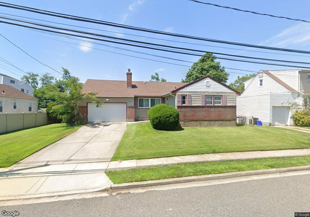
260 Westend Ave Freeport, NY 11520
Estimated Value: $619,153 - $662,000
3
Beds
2
Baths
1,263
Sq Ft
$507/Sq Ft
Est. Value
About This Home
This home is located at 260 Westend Ave, Freeport, NY 11520 and is currently estimated at $640,577, approximately $507 per square foot. 260 Westend Ave is a home located in Nassau County with nearby schools including Columbus Avenue School, Caroline G. Atkinson Intermediate School, and John W Dodd Middle School.
Ownership History
Date
Name
Owned For
Owner Type
Purchase Details
Closed on
Jul 31, 2018
Sold by
Gabriel Lemmie
Bought by
Onuorah Lorreta
Current Estimated Value
Home Financials for this Owner
Home Financials are based on the most recent Mortgage that was taken out on this home.
Original Mortgage
$335,418
Outstanding Balance
$292,059
Interest Rate
4.62%
Mortgage Type
FHA
Estimated Equity
$348,518
Purchase Details
Closed on
Aug 21, 2008
Sold by
Lemmie Christopher and The Estate Of Cedric Lemmie
Bought by
Lemmie Raiza Mendoza
Purchase Details
Closed on
Oct 30, 1998
Sold by
Skelly Eva
Bought by
Lemmie Cedric J
Create a Home Valuation Report for This Property
The Home Valuation Report is an in-depth analysis detailing your home's value as well as a comparison with similar homes in the area
Home Values in the Area
Average Home Value in this Area
Purchase History
| Date | Buyer | Sale Price | Title Company |
|---|---|---|---|
| Onuorah Lorreta | $347,000 | Clearpoint Title | |
| Lemmie Raiza Mendoza | -- | Attorney | |
| Lemmie Cedric J | $164,000 | -- |
Source: Public Records
Mortgage History
| Date | Status | Borrower | Loan Amount |
|---|---|---|---|
| Open | Onuorah Lorreta | $335,418 |
Source: Public Records
Tax History Compared to Growth
Tax History
| Year | Tax Paid | Tax Assessment Tax Assessment Total Assessment is a certain percentage of the fair market value that is determined by local assessors to be the total taxable value of land and additions on the property. | Land | Improvement |
|---|---|---|---|---|
| 2025 | $6,878 | $325 | $145 | $180 |
| 2024 | $769 | $342 | $153 | $189 |
| 2023 | $8,040 | $354 | $159 | $195 |
| 2022 | $8,040 | $342 | $153 | $189 |
| 2021 | $11,959 | $377 | $163 | $214 |
| 2020 | $10,768 | $745 | $462 | $283 |
| 2019 | $1,236 | $745 | $462 | $283 |
| 2018 | $5,569 | $745 | $0 | $0 |
| 2017 | $8,966 | $745 | $462 | $283 |
| 2016 | $10,084 | $745 | $462 | $283 |
| 2015 | $1,076 | $745 | $462 | $283 |
| 2014 | $1,076 | $745 | $462 | $283 |
| 2013 | $1,017 | $745 | $462 | $283 |
Source: Public Records
Map
Nearby Homes
- 28 Florence Ave
- 8 Florence Ave Unit 16C
- 214 Westend Ave Unit 6c
- 210 Westend Ave Unit 8B
- 12 Florence Ave Unit 29A
- 587 S Bayview Ave
- 77 Hampton Place
- 90 Hampton Place
- 159 Branch Ave
- 1116 Washington Place
- 1108 Washington Place
- 1166 Hastings Cir
- 153 Westend Ave
- 106 Irving Ave
- 205 Saint Marks Ave
- 1165 Hastings Cir
- 1130 Hayes Place
- 226 Westside Ave Unit B
- 110 Stirling Ave
- 1130 Van Buren Place
- 264 Westend Ave
- 11 Jeanette Ave
- 9 Jeanette Ave
- 56 Meister Blvd
- 3 Florence Ave
- 15 Florence Ave Unit A
- 17 Florence Ave
- 60 Meister Blvd
- 257 Westend Ave
- 263 Westend Ave
- 249 Westend Ave
- 42 Meister Blvd
- 12 Jeanette Ave
- 245 Westend Ave
- 16 Jeanette Ave
- 25 Florence Ave
- 28 Gerald Ave
- 78 Meister Blvd
- 24 Gerald Ave
- 36 Gerald Ave