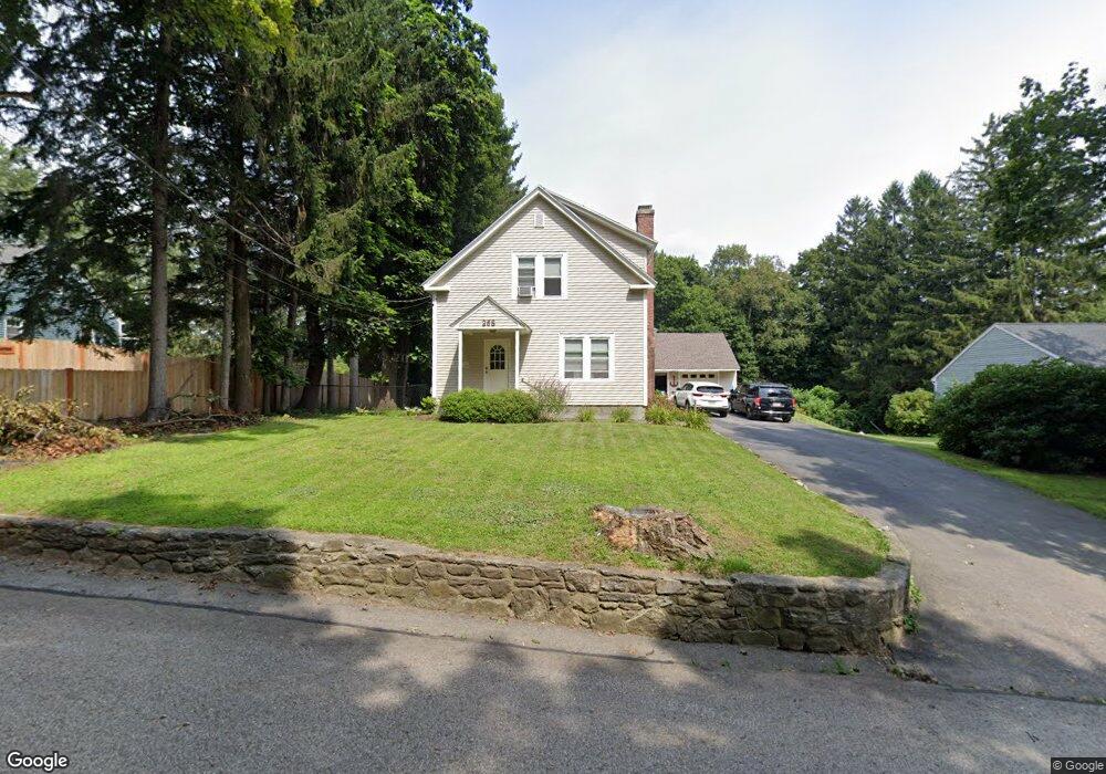
268 Parker Ave Holden, MA 01520
Estimated Value: $514,000 - $648,000
4
Beds
2
Baths
2,185
Sq Ft
$264/Sq Ft
Est. Value
About This Home
This home is located at 268 Parker Ave, Holden, MA 01520 and is currently estimated at $575,897, approximately $263 per square foot. 268 Parker Ave is a home located in Worcester County with nearby schools including Wachusett Regional High School, Abby Kelley Foster Charter Public School, and Bancroft School.
Ownership History
Date
Name
Owned For
Owner Type
Purchase Details
Closed on
Jun 27, 2013
Sold by
Snioch Pawel and Snioch Agnieszka
Bought by
Beeaucage Randy L
Current Estimated Value
Home Financials for this Owner
Home Financials are based on the most recent Mortgage that was taken out on this home.
Original Mortgage
$257,500
Outstanding Balance
$183,953
Interest Rate
3.51%
Mortgage Type
New Conventional
Estimated Equity
$391,944
Purchase Details
Closed on
Nov 1, 2007
Sold by
Option One Mortgage Co
Bought by
Snioch Agnieszka and Snioch Pawel
Purchase Details
Closed on
Mar 21, 2007
Sold by
Noone Gail A
Bought by
Wells Fargo Bank Na
Purchase Details
Closed on
Nov 22, 2000
Sold by
Adams Gunhilde P
Bought by
Noone Gail A and Rigney George H
Home Financials for this Owner
Home Financials are based on the most recent Mortgage that was taken out on this home.
Original Mortgage
$183,487
Interest Rate
7.78%
Mortgage Type
Purchase Money Mortgage
Create a Home Valuation Report for This Property
The Home Valuation Report is an in-depth analysis detailing your home's value as well as a comparison with similar homes in the area
Home Values in the Area
Average Home Value in this Area
Purchase History
| Date | Buyer | Sale Price | Title Company |
|---|---|---|---|
| Beeaucage Randy L | $257,500 | -- | |
| Snioch Agnieszka | $167,000 | -- | |
| Wells Fargo Bank Na | $263,500 | -- | |
| Noone Gail A | $185,000 | -- |
Source: Public Records
Mortgage History
| Date | Status | Borrower | Loan Amount |
|---|---|---|---|
| Open | Beeaucage Randy L | $257,500 | |
| Previous Owner | Noone Gail A | $183,487 |
Source: Public Records
Tax History Compared to Growth
Tax History
| Year | Tax Paid | Tax Assessment Tax Assessment Total Assessment is a certain percentage of the fair market value that is determined by local assessors to be the total taxable value of land and additions on the property. | Land | Improvement |
|---|---|---|---|---|
| 2025 | $6,503 | $469,200 | $150,400 | $318,800 |
| 2024 | $6,065 | $428,600 | $146,000 | $282,600 |
| 2023 | $6,138 | $409,500 | $126,900 | $282,600 |
| 2022 | $5,650 | $341,200 | $99,100 | $242,100 |
| 2021 | $5,469 | $314,300 | $94,400 | $219,900 |
| 2020 | $4,922 | $289,500 | $89,900 | $199,600 |
| 2019 | $4,841 | $277,400 | $89,900 | $187,500 |
| 2018 | $4,665 | $264,900 | $85,500 | $179,400 |
| 2017 | $4,587 | $260,800 | $85,500 | $175,300 |
| 2016 | $4,428 | $256,700 | $81,400 | $175,300 |
| 2015 | $4,505 | $248,600 | $81,400 | $167,200 |
| 2014 | $4,333 | $244,100 | $81,400 | $162,700 |
Source: Public Records
Map
Nearby Homes
- 29 Glenwood St
- 9 Idalla Ave
- 22 Danielles Way
- 26 Danielles Way
- 31 Danielles Way
- 93 Winfield Rd
- 23 Orono St
- 83 Stoneleigh Rd
- 12 Dixfield Rd
- 15 Cumberland St
- 29 Isleboro St
- 3 Malden St
- 33 Isleboro St
- 39 Meola Ave
- 33 Meola Ave
- 1097 W Boylston St
- 1110 W Boylston St Unit A
- 602 Burncoat St
- 21 Wyoming Dr
- 15 Lowell Ave
- 56 Lanesboro Rd
- 266 Parker Ave
- 54 Lanesboro Rd
- 31 Lanesboro Rd
- 257 Parker Ave
- 29 Lanesboro Rd
- 68 Lanesboro Rd
- 245 Parker Ave
- 78 Lanesboro Rd
- 248 Parker Ave
- 80 Lanesboro Rd
- 235 Parker Ave
- 13 Glenwood Ave
- 86 Lanesboro Rd
- 225 Parker Ave
- 191 Cook St
- 88 Lanesboro Rd
- 28 Lanesboro Rd
- 11 Glenwood Ave
- 8 Glenwood Ave