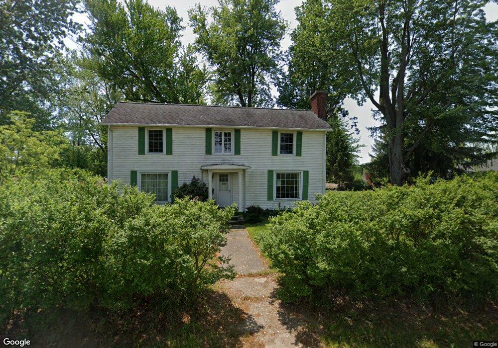
27961 Maystead Rd Sturgis, MI 49091
Estimated Value: $148,000
--
Bed
--
Bath
--
Sq Ft
1.02
Acres
About This Home
This home is located at 27961 Maystead Rd, Sturgis, MI 49091 and is currently estimated at $148,000. 27961 Maystead Rd is a home located in St. Joseph County with nearby schools including Sturgis High School, Lake Area Christian School, and St John's Lutheran School.
Ownership History
Date
Name
Owned For
Owner Type
Purchase Details
Closed on
Aug 7, 2018
Sold by
Baldwin David B and Baldwin Jocelyn Jane
Bought by
Baldwin David B and Baldwin Grantor Revoca David B
Current Estimated Value
Purchase Details
Closed on
May 21, 2008
Sold by
Sr Jr Real Estate Development Llc
Bought by
Jocelyn Jane Baldwin Revocable Trust
Purchase Details
Closed on
Jul 7, 2006
Sold by
Rackouski Bruce M
Bought by
Sr Jr Real Estate Development Llc
Purchase Details
Closed on
Mar 28, 1997
Sold by
Togtman Harold J and Togtman Wendy
Bought by
Rackouski Bruce M
Purchase Details
Closed on
Feb 27, 1997
Sold by
Tootman Jr Harold J and Tootman Wendy
Bought by
Rackouski Bruce M
Purchase Details
Closed on
Apr 4, 1992
Sold by
Sturgis Development Co Inc
Bought by
Togman Harold J and Togman Wendy
Create a Home Valuation Report for This Property
The Home Valuation Report is an in-depth analysis detailing your home's value as well as a comparison with similar homes in the area
Home Values in the Area
Average Home Value in this Area
Purchase History
| Date | Buyer | Sale Price | Title Company |
|---|---|---|---|
| Baldwin David B | -- | None Available | |
| Jocelyn Jane Baldwin Revocable Trust | $20,000 | None Available | |
| Sr Jr Real Estate Development Llc | $200,000 | None Available | |
| Rackouski Bruce M | $50,000 | -- | |
| Rackouski Bruce M | $50,000 | -- | |
| Rackouski Bruce M | -- | -- | |
| Togman Harold J | -- | -- |
Source: Public Records
Tax History Compared to Growth
Tax History
| Year | Tax Paid | Tax Assessment Tax Assessment Total Assessment is a certain percentage of the fair market value that is determined by local assessors to be the total taxable value of land and additions on the property. | Land | Improvement |
|---|---|---|---|---|
| 2025 | $69 | $3,600 | $3,600 | $0 |
| 2024 | $24 | $3,600 | $3,600 | $0 |
| 2023 | $23 | $2,200 | $2,200 | $0 |
| 2022 | $0 | $2,200 | $2,200 | $0 |
| 2021 | $61 | $2,200 | $2,200 | $0 |
| 2020 | $60 | $2,000 | $2,000 | $0 |
| 2019 | $60 | $2,000 | $2,000 | $0 |
| 2018 | $54 | $2,000 | $2,000 | $0 |
| 2017 | $56 | $2,000 | $2,000 | $0 |
| 2016 | -- | $2,000 | $2,000 | $0 |
| 2015 | -- | $2,200 | $2,200 | $0 |
| 2014 | -- | $2,600 | $2,600 | $0 |
| 2012 | -- | $2,600 | $2,600 | $0 |
Source: Public Records
Map
Nearby Homes
- V/L White Pine Dr
- 27810 Maystead Rd
- 28195 Blackberry Ln
- 66223 Grey Lake Rd
- 28123 Timberly Dr
- 0 V L M66- 102+ - Unit 24045986
- 27304 Oak Dr
- 66109 Hideaway Ln
- 1100 Sherwood Forrest Trail
- 708 N Centerville Rd
- 814 N Lakeview Ave
- V/L Banker St
- 612 N Prospect St
- 610 N Prospect St
- 609 Sturgis St
- 502 E Jerolene St
- 607 George St
- 805 N Nottawa St
- 418 Center Ave
- 404 Susan Ave
- 27961 Maystead Rd
- 27961 Maystead Rd
- 27961 Maystead Rd
- 27961 Maystead Rd
- 28190 Maystead Rd
- 28190 Maystead Rd
- 28185 Maystead Rd
- 28143 Maystead Rd
- 28429 Maystead Rd
- 64671 Prairie Lake Rd
- 64631 Prairie Lake Rd
- Lot 4 Mamroe Landing Rd
- 28270 Mamroe Landing Rd
- 28280 Mamroe Landing Rd
- 28551 Maystead Rd
- 28292 Mamroe Landing Rd
- 28324 Mamroe Landing Rd
- 28340 Mamroe Landing Rd
- 28382 Mamroe Landing Rd
- 28368 Mamroe Landing Rd