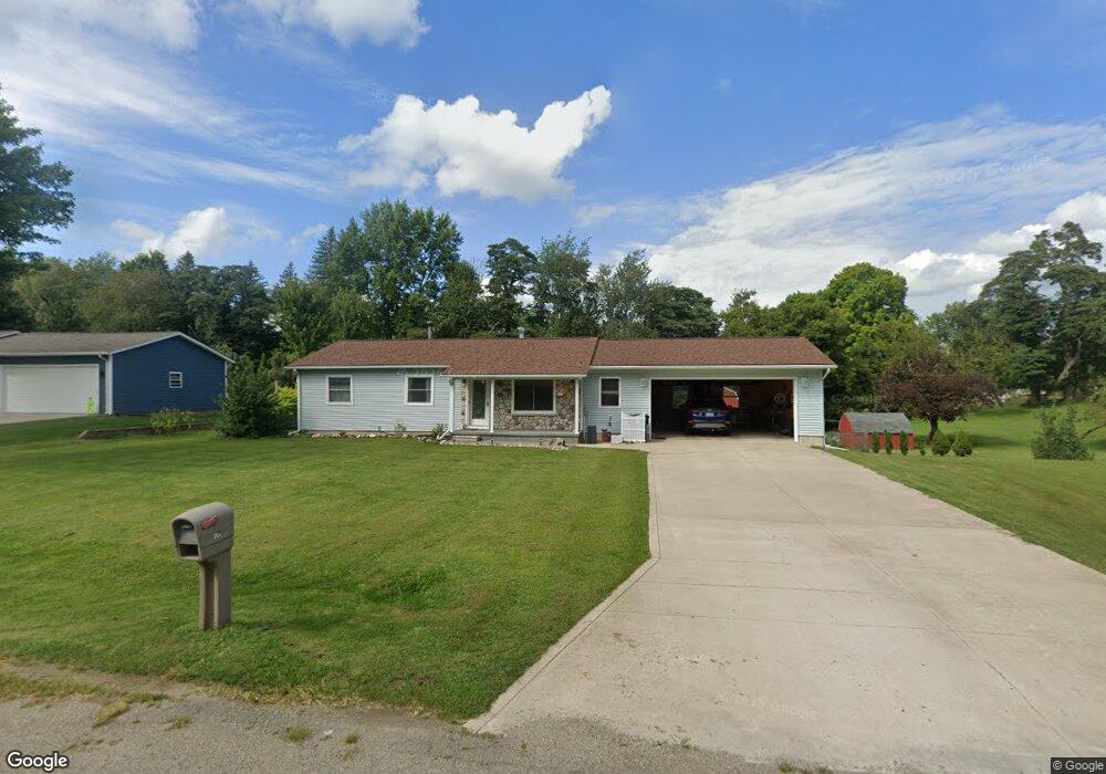
280 Jamie Dr Coldwater, MI 49036
Estimated Value: $214,379 - $260,000
3
Beds
1
Bath
1,040
Sq Ft
$225/Sq Ft
Est. Value
About This Home
This home is located at 280 Jamie Dr, Coldwater, MI 49036 and is currently estimated at $233,595, approximately $224 per square foot. 280 Jamie Dr is a home located in Branch County with nearby schools including Coldwater High School, Pansophia Academy, and St. Paul Lutheran School - Coldwater.
Ownership History
Date
Name
Owned For
Owner Type
Purchase Details
Closed on
Mar 29, 2022
Sold by
Gessinger Angela M and Gessinger Chistopher Scott
Bought by
Gessinger Angela M
Current Estimated Value
Purchase Details
Closed on
Feb 14, 2008
Sold by
Gessinger Angela M and Baird Angela M
Bought by
Gessinger Angela M and Gessinger Christopher S
Purchase Details
Closed on
Apr 29, 2006
Sold by
Allman Kevin L and Allman Billie J
Bought by
Baird Angela M
Home Financials for this Owner
Home Financials are based on the most recent Mortgage that was taken out on this home.
Original Mortgage
$110,000
Interest Rate
6.39%
Mortgage Type
Fannie Mae Freddie Mac
Purchase Details
Closed on
Nov 3, 1999
Sold by
Sarles Michelle A
Bought by
Allman Kevin L and Allman Billie J
Create a Home Valuation Report for This Property
The Home Valuation Report is an in-depth analysis detailing your home's value as well as a comparison with similar homes in the area
Home Values in the Area
Average Home Value in this Area
Purchase History
| Date | Buyer | Sale Price | Title Company |
|---|---|---|---|
| Gessinger Angela M | -- | None Listed On Document | |
| Gessinger Angela M | -- | Branch County Abstract & Tit | |
| Baird Angela M | $108,000 | Branch County Abstract & Tit | |
| Allman Kevin L | $77,000 | -- |
Source: Public Records
Mortgage History
| Date | Status | Borrower | Loan Amount |
|---|---|---|---|
| Previous Owner | Baird Angela M | $110,000 |
Source: Public Records
Tax History Compared to Growth
Tax History
| Year | Tax Paid | Tax Assessment Tax Assessment Total Assessment is a certain percentage of the fair market value that is determined by local assessors to be the total taxable value of land and additions on the property. | Land | Improvement |
|---|---|---|---|---|
| 2025 | $1,527 | $91,700 | $0 | $0 |
| 2024 | $611 | $82,600 | $0 | $0 |
| 2023 | -- | $77,900 | $0 | $0 |
| 2022 | $1,494 | $73,200 | $0 | $0 |
| 2021 | $1,478 | $69,700 | $0 | $0 |
| 2020 | -- | $68,400 | $0 | $0 |
| 2019 | -- | $59,400 | $0 | $0 |
| 2018 | -- | $52,200 | $0 | $0 |
| 2017 | -- | $52,500 | $0 | $0 |
| 2016 | -- | $52,600 | $0 | $0 |
| 2015 | -- | $47,700 | $0 | $0 |
| 2014 | -- | $36,800 | $0 | $0 |
| 2013 | -- | $36,800 | $0 | $0 |
Source: Public Records
Map
Nearby Homes
- 0 Hillcrest Dr
- 268 Paradise Island Dr
- VL In Lake N
- 217 S Moor Dr Unit 7
- 566 Angler Ave Unit 11
- 215 W State St
- 370 Bishop Ave
- 44 Candlewood Ct
- 520 Pamela Dr
- 17 Alandale Dr
- 335 Fairway Dr
- 150 Oakwood Dr
- 12 Bishop Ave
- 614 Marshall Rd
- 77 Maple Ln
- 90 Oakdale Ln
- 414 River Rd
- 667 River Rd
- 377 Marshall St
- 371 Marshall St