Estimated Value: $428,517 - $588,000
2
Beds
1
Bath
744
Sq Ft
$703/Sq Ft
Est. Value
About This Home
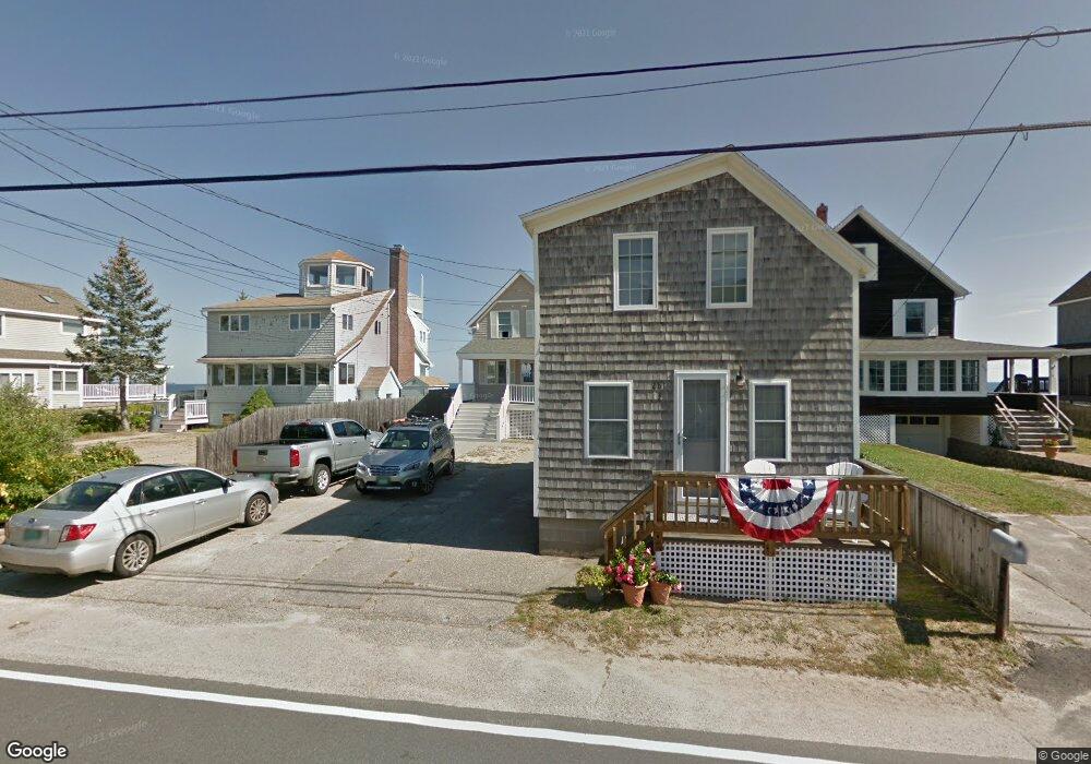
This home is located at 281 Atlantic Ave Unit 1, Wells, ME 04090 and is currently estimated at $523,129, approximately $703 per square foot. 281 Atlantic Ave Unit 1 is a home located in York County with nearby schools including Wells Junior High School, Wells Elementary School, and Wells High School.
Ownership History
Date
Name
Owned For
Owner Type
Purchase Details
Closed on
Apr 15, 2025
Sold by
Slosek David B
Bought by
David B Slosek T B and David Slosek
Current Estimated Value
Purchase Details
Closed on
Mar 16, 2022
Sold by
Slosek Wayne M
Bought by
Slosek
Purchase Details
Closed on
Dec 6, 2017
Sold by
Pitt Kathleen S
Bought by
Slosek Wayne M and Slosek David B
Purchase Details
Closed on
Aug 30, 2013
Sold by
Slosek Dori L
Bought by
Slosek David B and Kobbs Michelle A
Create a Home Valuation Report for This Property
The Home Valuation Report is an in-depth analysis detailing your home's value as well as a comparison with similar homes in the area
Home Values in the Area
Average Home Value in this Area
Purchase History
| Date | Buyer | Sale Price | Title Company |
|---|---|---|---|
| David B Slosek T B | -- | None Available | |
| David B Slosek T B | -- | None Available | |
| David B Slosek T B | -- | None Available | |
| Slosek | -- | None Available | |
| Slosek | -- | None Available | |
| Slosek | -- | None Available | |
| Slosek Wayne M | $112,500 | -- | |
| Slosek Wayne M | $112,500 | -- | |
| Slosek Wayne M | $112,500 | -- | |
| Slosek David B | -- | -- | |
| Slosek David B | -- | -- |
Source: Public Records
Tax History Compared to Growth
Tax History
| Year | Tax Paid | Tax Assessment Tax Assessment Total Assessment is a certain percentage of the fair market value that is determined by local assessors to be the total taxable value of land and additions on the property. | Land | Improvement |
|---|---|---|---|---|
| 2024 | $2,654 | $436,570 | $244,200 | $192,370 |
| 2023 | $2,602 | $436,570 | $244,200 | $192,370 |
| 2022 | $2,572 | $245,890 | $111,020 | $134,870 |
| 2021 | $2,556 | $242,930 | $111,020 | $131,910 |
| 2020 | $2,375 | $226,630 | $111,020 | $115,610 |
| 2019 | $2,361 | $226,630 | $111,020 | $115,610 |
| 2018 | $2,339 | $226,630 | $111,020 | $115,610 |
| 2017 | $2,303 | $226,630 | $111,020 | $115,610 |
| 2016 | $2,280 | $226,630 | $111,020 | $115,610 |
| 2015 | $2,255 | $226,630 | $111,020 | $115,610 |
| 2013 | $2,067 | $226,630 | $111,020 | $115,610 |
Source: Public Records
Map
Nearby Homes
- 9 Robert Ln
- 446 Atlantic Ave
- 500 Atlantic Ave Unit 2
- 61 Atlantic Ave Unit 3
- 58 Atlantic Ave Unit 12B
- 46 Ox Cart Ln
- 42 Rachel Carson Ln
- 105 Harbor Rd
- 99 Harbor Rd Unit Lot 52
- 99 Harbor Rd Unit Lot 54
- 4 Tidal Ct
- 1351 Post Rd Unit 49
- 1373 Post Rd Unit 10A
- 1373 Post Rd Unit 4E
- 1373 Post Rd Unit 2C
- 1373 Post Rd Unit 6B
- 1373 Post Rd Unit 1F
- 1290 Post Rd
- 1413 Post Rd Unit 58
- 60 Merrifield Ct
- 279 Atlantic Ave
- 277 Atlantic Ave
- 281 Atlantic Ave Unit 3
- 281 Atlantic Ave Unit 2
- 275 Atlantic Ave
- 247 Atlantic Ave
- 273 Atlantic Ave
- 271 Atlantic Ave
- 280 Atlantic Ave
- 276 Atlantic Ave
- 291 Atlantic Ave
- 284 Atlantic Ave
- 272 Atlantic Ave
- 9 Bosin St
- 11 Bosin St
- 288 Atlantic Ave
- 290 Atlantic Ave
- 292 Atlantic Ave
- 269 Atlantic Ave
- 12 Dolphin St