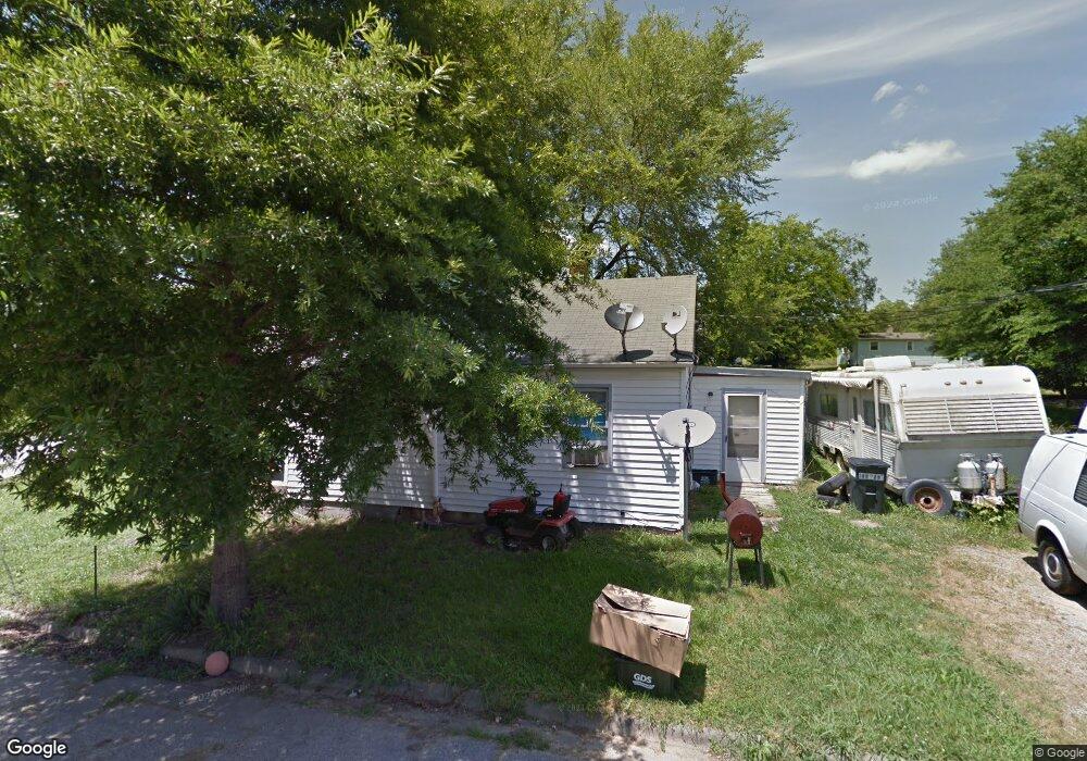
288 Mill St Mocksville, NC 27028
Estimated Value: $85,613 - $180,000
2
Beds
1
Bath
684
Sq Ft
$189/Sq Ft
Est. Value
About This Home
This home is located at 288 Mill St, Mocksville, NC 27028 and is currently estimated at $129,153, approximately $188 per square foot. 288 Mill St is a home located in Davie County with nearby schools including Mocksville Elementary School, South Davie Middle, and Davie County High School.
Ownership History
Date
Name
Owned For
Owner Type
Purchase Details
Closed on
Jul 30, 2025
Sold by
Horne Leslie L
Bought by
Leslie Leonora Brown Horne Revocable Trust and Horne
Current Estimated Value
Purchase Details
Closed on
Apr 11, 2007
Sold by
Dry Lawanda F and Dry Archie James
Bought by
Horne Brian and Horne Leslie
Purchase Details
Closed on
Nov 16, 2006
Sold by
Foote Cariel and Foote Lula Geneva
Bought by
Horne Brian and Horne Leslie
Purchase Details
Closed on
Mar 7, 2006
Sold by
Foote Cariel and Foote Lula G
Bought by
Foote Lula G
Create a Home Valuation Report for This Property
The Home Valuation Report is an in-depth analysis detailing your home's value as well as a comparison with similar homes in the area
Home Values in the Area
Average Home Value in this Area
Purchase History
| Date | Buyer | Sale Price | Title Company |
|---|---|---|---|
| Leslie Leonora Brown Horne Revocable Trust | -- | None Listed On Document | |
| Leslie Leonora Brown Horne Revocable Trust | -- | None Listed On Document | |
| Horne Brian | -- | None Available | |
| Horne Brian | $22,500 | None Available | |
| Foote Lula G | -- | -- |
Source: Public Records
Tax History Compared to Growth
Tax History
| Year | Tax Paid | Tax Assessment Tax Assessment Total Assessment is a certain percentage of the fair market value that is determined by local assessors to be the total taxable value of land and additions on the property. | Land | Improvement |
|---|---|---|---|---|
| 2025 | $492 | $50,260 | $12,500 | $37,760 |
| 2024 | $456 | $42,900 | $12,500 | $30,400 |
| 2023 | $456 | $42,900 | $12,500 | $30,400 |
| 2022 | $456 | $42,900 | $12,500 | $30,400 |
| 2021 | $456 | $42,900 | $12,500 | $30,400 |
| 2020 | $441 | $41,250 | $12,500 | $28,750 |
| 2019 | $441 | $41,250 | $12,500 | $28,750 |
| 2018 | $441 | $41,250 | $12,500 | $28,750 |
| 2017 | $436 | $41,250 | $0 | $0 |
| 2016 | $455 | $42,990 | $0 | $0 |
| 2015 | $455 | $42,990 | $0 | $0 |
| 2014 | $408 | $42,990 | $0 | $0 |
| 2013 | -- | $42,990 | $0 | $0 |
Source: Public Records
Map
Nearby Homes
- 135 Winding Creek Rd
- 701 E Lexington Rd
- 412 S Main St
- 147 Ariel Ct
- 147 Charleston Meadow Loop
- 1 lot E Depot St
- 792 S Main St
- 408 Pine St
- 186 Crestview Dr
- 351 Honeysuckle St
- 408 E Lake Dr
- 172 Flannel Ln
- 110 W Church St
- 214 Park Ave
- 210 Birchwood Ln
- 181 New Hampshire Ct
- 241 W Church St
- 151 Birchwood Ln
- 115 New Hampshire Ct
- 115 New Hampshire Ct Unit 35