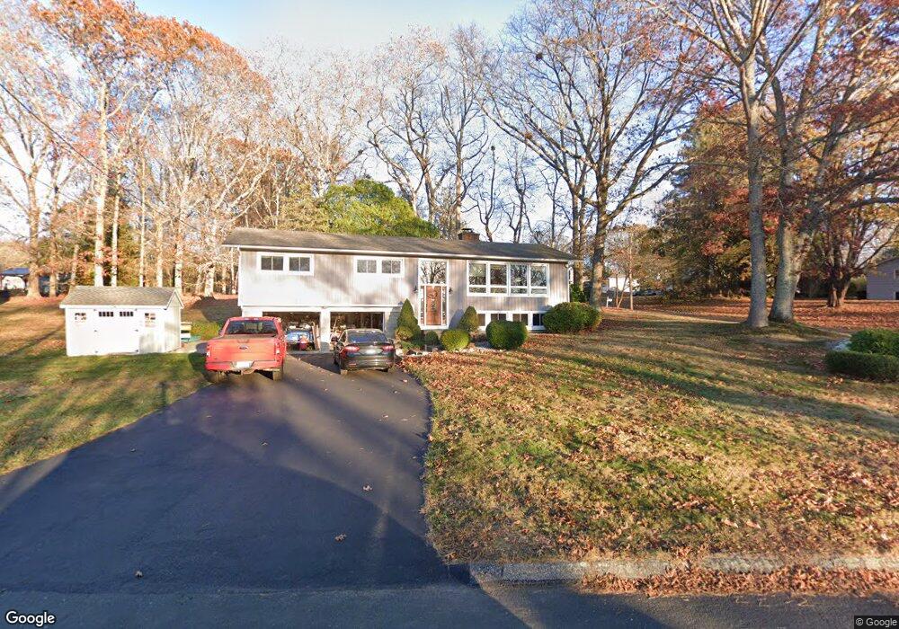
29 Laurel Hill Dr Niantic, CT 06357
Estimated Value: $388,000 - $564,000
3
Beds
3
Baths
1,508
Sq Ft
$319/Sq Ft
Est. Value
About This Home
This home is located at 29 Laurel Hill Dr, Niantic, CT 06357 and is currently estimated at $480,460, approximately $318 per square foot. 29 Laurel Hill Dr is a home located in New London County with nearby schools including East Lyme Middle School, East Lyme High School, and Carelot Children's Center - East Lyme.
Ownership History
Date
Name
Owned For
Owner Type
Purchase Details
Closed on
Dec 21, 1990
Sold by
Hirschberg Stuart
Bought by
Reinhart Ronald
Current Estimated Value
Home Financials for this Owner
Home Financials are based on the most recent Mortgage that was taken out on this home.
Original Mortgage
$132,450
Interest Rate
10.02%
Create a Home Valuation Report for This Property
The Home Valuation Report is an in-depth analysis detailing your home's value as well as a comparison with similar homes in the area
Home Values in the Area
Average Home Value in this Area
Purchase History
| Date | Buyer | Sale Price | Title Company |
|---|---|---|---|
| Reinhart Ronald | $140,000 | -- |
Source: Public Records
Mortgage History
| Date | Status | Borrower | Loan Amount |
|---|---|---|---|
| Closed | Reinhart Ronald | $26,000 | |
| Closed | Reinhart Ronald | $123,100 | |
| Closed | Reinhart Ronald | $128,700 | |
| Closed | Reinhart Ronald | $132,450 |
Source: Public Records
Tax History Compared to Growth
Tax History
| Year | Tax Paid | Tax Assessment Tax Assessment Total Assessment is a certain percentage of the fair market value that is determined by local assessors to be the total taxable value of land and additions on the property. | Land | Improvement |
|---|---|---|---|---|
| 2025 | $6,033 | $215,390 | $92,610 | $122,780 |
| 2024 | $5,676 | $215,390 | $92,610 | $122,780 |
| 2023 | $5,359 | $215,390 | $92,610 | $122,780 |
| 2022 | $5,135 | $215,390 | $92,610 | $122,780 |
| 2021 | $5,081 | $178,220 | $92,610 | $85,610 |
| 2020 | $5,054 | $178,220 | $92,610 | $85,610 |
| 2019 | $5,024 | $178,220 | $92,610 | $85,610 |
| 2018 | $4,874 | $178,220 | $92,610 | $85,610 |
| 2017 | $4,662 | $178,220 | $92,610 | $85,610 |
| 2016 | $4,399 | $173,460 | $92,610 | $80,850 |
| 2015 | $4,286 | $173,460 | $92,610 | $80,850 |
| 2014 | $4,151 | $172,760 | $92,610 | $80,150 |
Source: Public Records
Map
Nearby Homes
- 156 Flanders Rd
- 10 S Ledge Rock Rd
- 72 Society Rd
- 16 Cubles Dr
- 28 Alexander Dr
- 138 Boston Post Rd Unit 10
- 138 Boston Post Rd Unit 11
- 138 Boston Post Rd Unit 16
- 138 Boston Post Rd Unit 17
- 138 Boston Post Rd Unit 3
- 13 Willow Ln
- 20 North Rd
- 25 Marion Dr
- 163 Oswegatchie Rd
- 37 Stoneywood Dr
- 139 Oswegatchie Rd
- 29 Oswegatchie Rd
- 231 Boston Post Rd Unit 9
- 6 Marion Dr
- 32 Upper Pattagansett Rd Unit 8
- 6 N Ledge Rock Rd
- 33 Laurel Hill Dr
- 30 Laurel Hill Dr
- 28 Laurel Hill Dr
- 8 N Ledge Rock Rd
- 23 Laurel Hill Dr
- 32 Laurel Hill Dr
- 39 Laurel Hill Dr
- 26 Laurel Hill Dr
- 5 N Ledge Rock Rd
- 24 Laurel Hill Dr
- 34 Laurel Hill Dr
- 10 N Ledge Rock Rd
- 7 N Ledge Rock Rd
- 43 Laurel Hill Dr
- 22 Laurel Hill Dr
- 21 Laurel Hill Dr
- 36 Laurel Hill Dr
- 9 N Ledge Rock Rd
- 45 Laurel Hill Dr