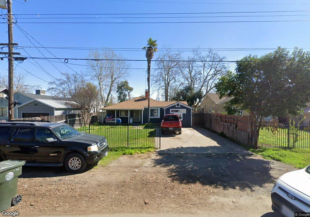
2920 Connie Dr Sacramento, CA 95815
Ben Ali NeighborhoodEstimated Value: $238,000 - $324,000
2
Beds
1
Bath
928
Sq Ft
$317/Sq Ft
Est. Value
About This Home
This home is located at 2920 Connie Dr, Sacramento, CA 95815 and is currently estimated at $293,913, approximately $316 per square foot. 2920 Connie Dr is a home located in Sacramento County with nearby schools including D. W. Babcock Elementary, Martin Luther King Jr. Technology Academy, and Grant Union High School.
Ownership History
Date
Name
Owned For
Owner Type
Purchase Details
Closed on
Jul 20, 2023
Sold by
Unknown
Bought by
Hanson Family Trust and Hanson
Current Estimated Value
Purchase Details
Closed on
Oct 12, 2003
Sold by
Bingham Gordon R and Bingham Candy E
Bought by
Hanson Vincent John
Purchase Details
Closed on
May 13, 1999
Sold by
Bingham Gordon R
Bought by
Bingham Gordon R and Bingham Candy E
Home Financials for this Owner
Home Financials are based on the most recent Mortgage that was taken out on this home.
Original Mortgage
$43,800
Interest Rate
6.92%
Mortgage Type
Stand Alone First
Create a Home Valuation Report for This Property
The Home Valuation Report is an in-depth analysis detailing your home's value as well as a comparison with similar homes in the area
Home Values in the Area
Average Home Value in this Area
Purchase History
| Date | Buyer | Sale Price | Title Company |
|---|---|---|---|
| Hanson Family Trust | -- | None Listed On Document | |
| Hanson Vincent John | $120,000 | First American Title Co | |
| Bingham Gordon R | -- | American Title Co |
Source: Public Records
Mortgage History
| Date | Status | Borrower | Loan Amount |
|---|---|---|---|
| Previous Owner | Bingham Gordon R | $43,800 |
Source: Public Records
Tax History Compared to Growth
Tax History
| Year | Tax Paid | Tax Assessment Tax Assessment Total Assessment is a certain percentage of the fair market value that is determined by local assessors to be the total taxable value of land and additions on the property. | Land | Improvement |
|---|---|---|---|---|
| 2025 | $2,069 | $170,594 | $42,642 | $127,952 |
| 2024 | $2,069 | $167,250 | $41,806 | $125,444 |
| 2023 | $2,078 | $163,972 | $40,987 | $122,985 |
| 2022 | $1,960 | $160,758 | $40,184 | $120,574 |
| 2021 | $1,951 | $157,607 | $39,397 | $118,210 |
| 2020 | $1,931 | $155,992 | $38,994 | $116,998 |
| 2019 | $1,905 | $152,934 | $38,230 | $114,704 |
| 2018 | $1,811 | $149,936 | $37,481 | $112,455 |
| 2017 | $1,791 | $141,779 | $35,442 | $106,337 |
| 2016 | $1,681 | $130,073 | $32,516 | $97,557 |
| 2015 | $1,458 | $117,184 | $29,294 | $87,890 |
| 2014 | $1,447 | $111,604 | $27,899 | $83,705 |
Source: Public Records
Map
Nearby Homes
- 2849 Aurora Ave
- 1923 Juliesse Ave
- 2133 Marconi Ave
- 2137 Marconi Ave
- 2818 Plover St
- 2155 Whippoorwill Ln
- 2115 Ruby Ct
- 1851 Glenrose Ave
- 2620 Darwin St
- 2265 Marconi Ave
- 3135 Academy Way
- 2513 Anna Way
- 2500 Ethan Way
- 1757 Kenwood St
- 1705 Kenwood St
- 2012 El Camino Ave
- 3139 Judah St
- 2436 Connie Dr
- 2257 Edison Ave
- 2405 Ethan Way