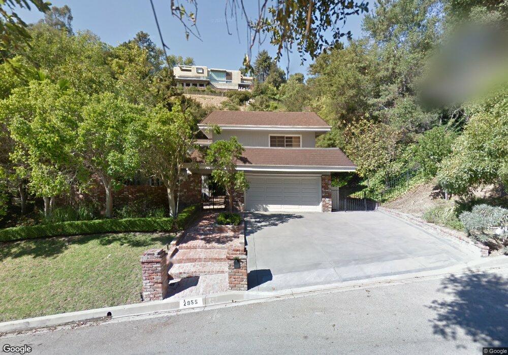
2955 Hutton Dr Beverly Hills, CA 90210
Beverly Crest NeighborhoodEstimated Value: $2,603,312 - $3,141,000
4
Beds
3
Baths
2,669
Sq Ft
$1,033/Sq Ft
Est. Value
About This Home
This home is located at 2955 Hutton Dr, Beverly Hills, CA 90210 and is currently estimated at $2,757,078, approximately $1,033 per square foot. 2955 Hutton Dr is a home located in Los Angeles County with nearby schools including Warner Avenue Elementary.
Ownership History
Date
Name
Owned For
Owner Type
Purchase Details
Closed on
Sep 11, 2003
Sold by
Silverman Jay J and Silverman Janet
Bought by
Silverman Jay J
Current Estimated Value
Purchase Details
Closed on
May 23, 1995
Sold by
Simon Deborah J
Bought by
Silverman Jay J
Home Financials for this Owner
Home Financials are based on the most recent Mortgage that was taken out on this home.
Original Mortgage
$235,600
Interest Rate
7.92%
Create a Home Valuation Report for This Property
The Home Valuation Report is an in-depth analysis detailing your home's value as well as a comparison with similar homes in the area
Home Values in the Area
Average Home Value in this Area
Purchase History
| Date | Buyer | Sale Price | Title Company |
|---|---|---|---|
| Silverman Jay J | -- | -- | |
| Silverman Jay J | $625,000 | Gateway Title |
Source: Public Records
Mortgage History
| Date | Status | Borrower | Loan Amount |
|---|---|---|---|
| Closed | Silverman Jay J | $235,600 | |
| Closed | Silverman Jay J | $189,400 |
Source: Public Records
Tax History Compared to Growth
Tax History
| Year | Tax Paid | Tax Assessment Tax Assessment Total Assessment is a certain percentage of the fair market value that is determined by local assessors to be the total taxable value of land and additions on the property. | Land | Improvement |
|---|---|---|---|---|
| 2025 | $13,270 | $1,076,578 | $719,917 | $356,661 |
| 2024 | $13,270 | $1,055,469 | $705,801 | $349,668 |
| 2023 | $13,022 | $1,034,774 | $691,962 | $342,812 |
| 2022 | $12,459 | $1,014,486 | $678,395 | $336,091 |
| 2021 | $12,300 | $994,595 | $665,094 | $329,501 |
| 2019 | $11,873 | $965,097 | $645,368 | $319,729 |
| 2018 | $11,767 | $946,174 | $632,714 | $313,460 |
| 2016 | $11,215 | $909,435 | $608,146 | $301,289 |
| 2015 | $11,053 | $895,776 | $599,012 | $296,764 |
| 2014 | $11,100 | $878,230 | $587,279 | $290,951 |
Source: Public Records
Map
Nearby Homes
- 3001 Hutton Place
- 2973 Hutton Dr
- 9767 Blantyre Dr
- 9697 Moorgate Rd
- 2791 Hutton Dr
- 9715 Arby Dr
- 13320 Mulholland Dr
- 13170 Mulholland Dr
- 13345 Mulholland Dr
- 2731 Hutton Dr
- 13355 Mulholland Dr
- 13150 Mulholland Dr
- 2481 Summitridge Dr
- 9696 Antelope Rd
- 13511 Mulholland Dr
- 2641 Hutton Dr
- 2451 Summitridge Dr
- 2870 & 2860 Beverly Dr
- 3372 Longridge Terrace
- 3430 Dixie Canyon Ave
- 2965 Hutton Dr
- 2941 Hutton Dr
- 2966 Hutton Dr
- 2985 Hutton Dr
- 3013 Hutton Dr
- 2920 Hutton Dr
- 3023 Hutton Dr
- 3005 Hutton Dr
- 3001 Hutton Dr
- 2930 Hutton Dr
- 3027 Hutton Dr
- 2972 Hutton Dr
- 2900 Hutton Dr
- 2940 Trudy Dr
- 3002 Hutton Place
- 2901 Hutton Dr
- 0 Drake Ln Unit U12003390
- 0 Drake Ln Unit NP13239390
- 2984 Hutton Dr
- 9789 Blantyre Dr