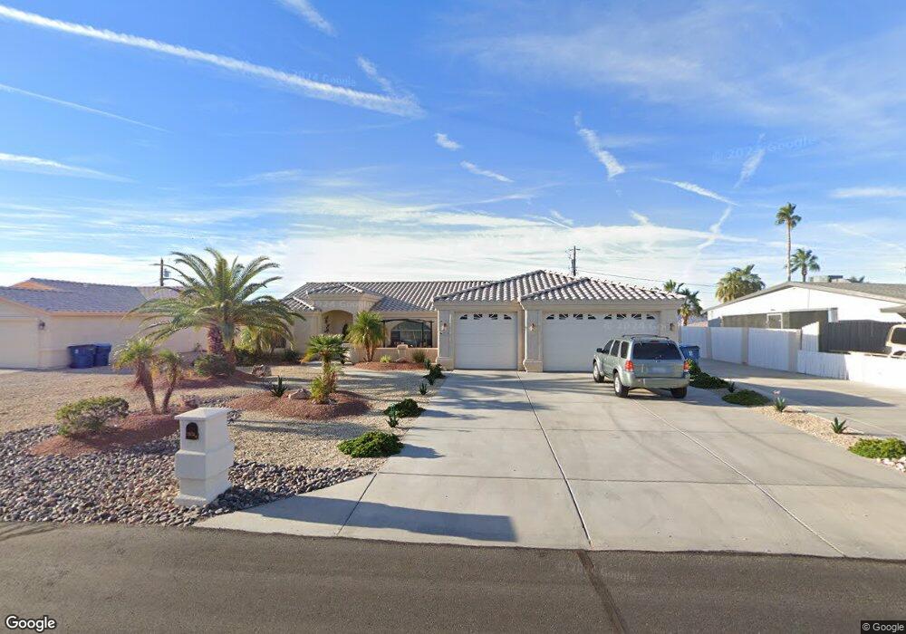
2970 Indian Land Dr Lake Havasu City, AZ 86406
Estimated Value: $547,000 - $686,212
3
Beds
2
Baths
1,852
Sq Ft
$333/Sq Ft
Est. Value
About This Home
This home is located at 2970 Indian Land Dr, Lake Havasu City, AZ 86406 and is currently estimated at $617,303, approximately $333 per square foot. 2970 Indian Land Dr is a home located in Mohave County with nearby schools including Starline Elementary School, Thunderbolt Middle School, and Lake Havasu High School.
Ownership History
Date
Name
Owned For
Owner Type
Purchase Details
Closed on
Apr 3, 2024
Sold by
Nancy Jean Harlow Revocable Trust and Harlow David Scott
Bought by
Harlow David Scott
Current Estimated Value
Purchase Details
Closed on
Oct 25, 2012
Sold by
Harlow Nancy J
Bought by
Harlow Nancy J
Purchase Details
Closed on
Mar 25, 2005
Sold by
Starr Harold F and Starr Mary Ann
Bought by
Harlow Nancy Jean
Home Financials for this Owner
Home Financials are based on the most recent Mortgage that was taken out on this home.
Original Mortgage
$100,000
Interest Rate
5.77%
Mortgage Type
New Conventional
Purchase Details
Closed on
Apr 20, 2004
Sold by
Hubler Edward W and Hubler Judith F
Bought by
Starr Harold F and Starr Mary Ann
Create a Home Valuation Report for This Property
The Home Valuation Report is an in-depth analysis detailing your home's value as well as a comparison with similar homes in the area
Home Values in the Area
Average Home Value in this Area
Purchase History
| Date | Buyer | Sale Price | Title Company |
|---|---|---|---|
| Harlow David Scott | -- | None Listed On Document | |
| Harlow Nancy J | -- | None Available | |
| Harlow Nancy Jean | $325,000 | Transnation Title Ins Co | |
| Starr Harold F | $79,900 | First American Title Ins Co |
Source: Public Records
Mortgage History
| Date | Status | Borrower | Loan Amount |
|---|---|---|---|
| Previous Owner | Harlow Nancy Jean | $100,000 |
Source: Public Records
Tax History Compared to Growth
Tax History
| Year | Tax Paid | Tax Assessment Tax Assessment Total Assessment is a certain percentage of the fair market value that is determined by local assessors to be the total taxable value of land and additions on the property. | Land | Improvement |
|---|---|---|---|---|
| 2026 | $1,055 | -- | -- | -- |
| 2025 | $2,136 | $54,324 | $0 | $0 |
| 2024 | $2,136 | $55,885 | $0 | $0 |
| 2023 | $2,136 | $48,627 | $0 | $0 |
| 2022 | $2,057 | $37,344 | $0 | $0 |
| 2021 | $2,282 | $34,343 | $0 | $0 |
| 2019 | $2,166 | $30,751 | $0 | $0 |
| 2018 | $2,093 | $28,593 | $0 | $0 |
| 2017 | $2,056 | $27,760 | $0 | $0 |
| 2016 | $1,816 | $26,600 | $0 | $0 |
| 2015 | $1,767 | $23,478 | $0 | $0 |
Source: Public Records
Map
Nearby Homes
- 3066 Star Dr
- 2890 Yuma Dr
- 700 Apache Dr
- 2820 Indian Springs Dr
- 3150 Star Dr
- 3135 Cotati Dr
- 680 Yosemite Dr
- 2970 War Eagle Dr
- 2910 Coconino Dr
- 850 Thunderbolt Ave
- 2951 Inca Dr
- 2821 Indian Pipe Dr
- 815 Rolling Hills Plaza N
- 786 Powder Dr
- 532 Roanoke Dr
- 2741 Jericho Dr
- 3261 Thundercloud Dr
- 691 Rolling Hills Dr
- 1041 Rolling Hills Dr
- 3072 Shoshone Dr
- 2980 Indian Land Dr
- 2960 Indian Land Dr
- 2975 Yuma Dr
- 2971 Yuma Dr
- 2990 Indian Land Dr
- 2981 Yuma Dr
- 2950 Indian Land Dr
- 2981 Indian Land
- 2981 Indian Land Dr
- 2981 Indian Land Dr
- 2991 Indian Land Dr
- 2985 Yuma Dr
- 2965 Yuma Dr
- 2971 Indian Land Dr
- 2965 Yuma Dr
- 3001 Indian Land Dr
- 2961 Indian Land Dr
- 3000 Indian Land Dr
- 2940 Indian Land Dr
- 3011 Indian Land Dr