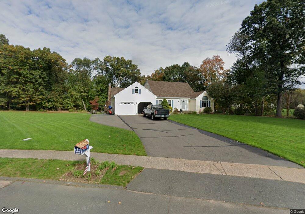
3 Brockway Rd Ellington, CT 06029
Estimated Value: $651,932 - $712,000
4
Beds
3
Baths
2,882
Sq Ft
$234/Sq Ft
Est. Value
About This Home
This home is located at 3 Brockway Rd, Ellington, CT 06029 and is currently estimated at $674,733, approximately $234 per square foot. 3 Brockway Rd is a home located in Tolland County with nearby schools including Ellington High School.
Ownership History
Date
Name
Owned For
Owner Type
Purchase Details
Closed on
Dec 6, 2023
Sold by
Litty Christopher M and Litty Laura S
Bought by
Christopher M Litty T M and Christopher Litty
Current Estimated Value
Purchase Details
Closed on
Sep 29, 1995
Sold by
Lacava Constr
Bought by
Litty Christopher and Litty Laura
Home Financials for this Owner
Home Financials are based on the most recent Mortgage that was taken out on this home.
Original Mortgage
$210,600
Interest Rate
7.89%
Mortgage Type
Purchase Money Mortgage
Create a Home Valuation Report for This Property
The Home Valuation Report is an in-depth analysis detailing your home's value as well as a comparison with similar homes in the area
Home Values in the Area
Average Home Value in this Area
Purchase History
| Date | Buyer | Sale Price | Title Company |
|---|---|---|---|
| Christopher M Litty T M | -- | None Available | |
| Litty Christopher | $234,200 | -- |
Source: Public Records
Mortgage History
| Date | Status | Borrower | Loan Amount |
|---|---|---|---|
| Previous Owner | Litty Christopher | $125,100 | |
| Previous Owner | Litty Christopher | $210,600 |
Source: Public Records
Tax History Compared to Growth
Tax History
| Year | Tax Paid | Tax Assessment Tax Assessment Total Assessment is a certain percentage of the fair market value that is determined by local assessors to be the total taxable value of land and additions on the property. | Land | Improvement |
|---|---|---|---|---|
| 2025 | $9,781 | $263,630 | $64,860 | $198,770 |
| 2024 | $9,491 | $263,630 | $64,860 | $198,770 |
| 2023 | $9,043 | $263,630 | $64,860 | $198,770 |
| 2022 | $8,568 | $263,630 | $64,860 | $198,770 |
| 2021 | $8,331 | $263,630 | $64,860 | $198,770 |
| 2020 | $9,205 | $282,360 | $65,900 | $216,460 |
| 2019 | $9,205 | $282,360 | $65,900 | $216,460 |
| 2016 | $8,612 | $282,360 | $65,900 | $216,460 |
| 2015 | $8,612 | $287,440 | $65,900 | $221,540 |
| 2014 | $8,250 | $287,440 | $65,900 | $221,540 |
Source: Public Records
Map
Nearby Homes
- 14 Brookfield Dr
- 5 Brockway Rd
- 7 Brockway Rd
- 12 Brookfield Dr
- 4 Brockway Rd
- 6 Brockway Rd
- 16 Windmill Rd
- 18 Windmill Rd
- 19 Brockway Rd
- 18 Brookfield Dr
- 7 Brookfield Dr
- 8 Brockway Rd
- 20 Windmill Rd
- 2 Brockway Rd
- 11 Brockway Rd
- 9 Brookfield Dr
- 2 Pine Ridge Rd
- 22 Windmill Rd
- 15 Brockway Rd
- 10 Windmill Rd