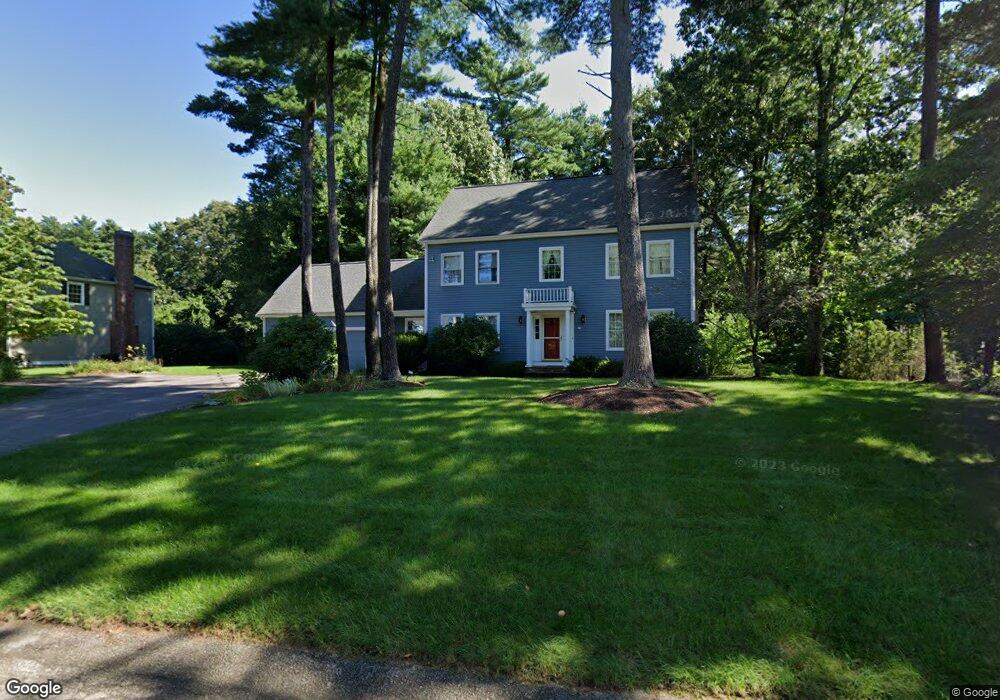
30 Hayden Woods Wrentham, MA 02093
Estimated Value: $857,999 - $1,030,000
4
Beds
3
Baths
2,461
Sq Ft
$369/Sq Ft
Est. Value
About This Home
This home is located at 30 Hayden Woods, Wrentham, MA 02093 and is currently estimated at $908,250, approximately $369 per square foot. 30 Hayden Woods is a home located in Norfolk County with nearby schools including Delaney Elementary School and Charles E Roderick.
Ownership History
Date
Name
Owned For
Owner Type
Purchase Details
Closed on
Feb 9, 2022
Sold by
Schwarm Stephen C and Schwarm Susan W
Bought by
Stephen C Schwarm Ret
Current Estimated Value
Purchase Details
Closed on
Aug 29, 2003
Sold by
Del Mar Dev Corp
Bought by
Rea Timothy M and Rea Linda M
Home Financials for this Owner
Home Financials are based on the most recent Mortgage that was taken out on this home.
Original Mortgage
$315,000
Interest Rate
5.69%
Mortgage Type
Purchase Money Mortgage
Purchase Details
Closed on
Aug 24, 1992
Sold by
Council Oaks Assoc Inc
Bought by
Schwarm Stephen C and Schwarm Susan W
Home Financials for this Owner
Home Financials are based on the most recent Mortgage that was taken out on this home.
Original Mortgage
$186,000
Interest Rate
8.12%
Mortgage Type
Purchase Money Mortgage
Create a Home Valuation Report for This Property
The Home Valuation Report is an in-depth analysis detailing your home's value as well as a comparison with similar homes in the area
Home Values in the Area
Average Home Value in this Area
Purchase History
| Date | Buyer | Sale Price | Title Company |
|---|---|---|---|
| Stephen C Schwarm Ret | -- | None Available | |
| Rea Timothy M | $716,400 | -- | |
| Schwarm Stephen C | $238,099 | -- |
Source: Public Records
Mortgage History
| Date | Status | Borrower | Loan Amount |
|---|---|---|---|
| Previous Owner | Schwarm Stephen C | $315,000 | |
| Previous Owner | Schwarm Stephen C | $186,000 |
Source: Public Records
Tax History Compared to Growth
Tax History
| Year | Tax Paid | Tax Assessment Tax Assessment Total Assessment is a certain percentage of the fair market value that is determined by local assessors to be the total taxable value of land and additions on the property. | Land | Improvement |
|---|---|---|---|---|
| 2025 | $8,619 | $743,700 | $290,700 | $453,000 |
| 2024 | $8,335 | $694,600 | $290,700 | $403,900 |
| 2023 | $8,247 | $653,500 | $264,300 | $389,200 |
| 2022 | $7,855 | $574,600 | $246,600 | $328,000 |
| 2021 | $7,276 | $517,100 | $215,300 | $301,800 |
| 2020 | $7,520 | $527,700 | $191,400 | $336,300 |
| 2019 | $7,234 | $512,300 | $191,400 | $320,900 |
| 2018 | $6,807 | $478,000 | $182,000 | $296,000 |
| 2017 | $6,672 | $468,200 | $178,500 | $289,700 |
| 2016 | $6,533 | $457,500 | $173,400 | $284,100 |
| 2015 | $6,510 | $434,600 | $166,700 | $267,900 |
| 2014 | $6,450 | $421,300 | $160,300 | $261,000 |
Source: Public Records
Map
Nearby Homes
- 570 Franklin St
- 131 Creek St Unit 7
- 10 Nature View Dr
- 15 Nature View Dr
- 11 Earle Stewart Ln
- Lot 3 - 14 Earle Stewart Ln
- Lot 1 - Blueberry 2 Car Plan at King Philip Estates
- Lot 8 - Blueberry 2 Car Plan at King Philip Estates
- Lot 5 - Hughes 2 car Plan at King Philip Estates
- Lot 6 - Blueberry 3 Car Plan at King Philip Estates
- Lot 2 - Camden 2 Car Plan at King Philip Estates
- Lot 7 - Cedar Plan at King Philip Estates
- Lot 4 - Hemingway 2 Car Plan at King Philip Estates
- Lot 3 - Blueberry 2 Car Plan at King Philip Estates
- 50 Reed Fulton Ave Unit Lot 61
- 270 Dedham St
- 45 Joshua Rd
- 1 Lorraine Metcalf Dr
- 246 Forest Grove Ave
- 319 Taunton St