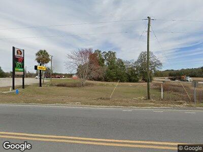
3000 Highway 378 Conway, SC 29527
Estimated Value: $159,097
--
Bed
--
Bath
2,250
Sq Ft
$71/Sq Ft
Est. Value
About This Home
This home is located at 3000 Highway 378, Conway, SC 29527 and is currently estimated at $159,097, approximately $70 per square foot. 3000 Highway 378 is a home located in Horry County with nearby schools including Pee Dee Elementary School, Whittemore Park Middle School, and Conway High School.
Ownership History
Date
Name
Owned For
Owner Type
Purchase Details
Closed on
Dec 13, 2010
Sold by
Hyman Greg
Bought by
Waste Industries Llc
Current Estimated Value
Purchase Details
Closed on
Oct 29, 2010
Sold by
Hyman Greg
Bought by
Xpress Autos Llc
Purchase Details
Closed on
Sep 21, 2003
Sold by
Dawsey Maxine Shelley and Dawsey Maxine S
Bought by
Phillips Richard Mcneil
Purchase Details
Closed on
Jan 24, 2000
Sold by
Jacor Inc
Bought by
Hyman Greg
Create a Home Valuation Report for This Property
The Home Valuation Report is an in-depth analysis detailing your home's value as well as a comparison with similar homes in the area
Home Values in the Area
Average Home Value in this Area
Purchase History
| Date | Buyer | Sale Price | Title Company |
|---|---|---|---|
| Waste Industries Llc | $70,000 | -- | |
| Xpress Autos Llc | $150,000 | -- | |
| Phillips Richard Mcneil | -- | -- | |
| Hyman Greg | $140,000 | -- |
Source: Public Records
Mortgage History
| Date | Status | Borrower | Loan Amount |
|---|---|---|---|
| Open | Carroll Jason | $150,000 |
Source: Public Records
Tax History Compared to Growth
Tax History
| Year | Tax Paid | Tax Assessment Tax Assessment Total Assessment is a certain percentage of the fair market value that is determined by local assessors to be the total taxable value of land and additions on the property. | Land | Improvement |
|---|---|---|---|---|
| 2024 | $2,421 | $8,287 | $3,564 | $4,723 |
| 2023 | $2,421 | $8,287 | $3,564 | $4,723 |
| 2021 | $2,269 | $9,498 | $3,564 | $5,934 |
| 2020 | $1,951 | $9,498 | $3,564 | $5,934 |
| 2019 | $1,855 | $9,498 | $3,564 | $5,934 |
| 2018 | $0 | $7,206 | $3,564 | $3,642 |
| 2017 | $1,613 | $7,206 | $3,564 | $3,642 |
| 2016 | -- | $7,206 | $3,564 | $3,642 |
| 2015 | $1,636 | $4,804 | $2,376 | $6,374 |
| 2014 | $1,584 | $7,206 | $3,564 | $3,642 |
Source: Public Records
Map
Nearby Homes
- 0 Airport Rd Unit 2509636
- 2626 Highway 378
- 1416 Leatherman Rd
- 1340 Valor Rd
- 801 Benchmade Rd
- 1001 Leatherman Rd
- 925 Oglethorpe Dr
- 1301 Pulaski St
- 908 Oglethorpe Dr
- 2429 Westbrook Dr
- 2446 Farmwood Cir
- 2437 Westbrook Dr
- 2914 Spain Ln
- 2404 Campton Loop
- 2412 Campton Loop
- 2494 Campton Loop
- 2490 Campton Loop
- 2443 Campton Loop
- 2420 Campton Loop
- 2441 Capri Ct
- 3000 Highway 378
- 2980 Highway 378
- 2937 Highway 378
- 2925 Highway 378
- 2043 Dirty Branch Rd
- 2886 Highway 378
- 0.50 Acres Highway 378
- 2897 Highway 378
- 2019 Dirty Branch Rd
- 2880 Highway 378
- 3130 Highway 378
- 2868 Highway 378
- 2827 Dayton Dr
- 2814 Dayton Dr
- 1966 Dirty Branch Rd
- 2857 Highway 378
- 2820 Dayton Dr
- 1962 Dirty Branch Rd
- TBD 1.0 Acre Highway 378
- 2828 Dayton Dr
