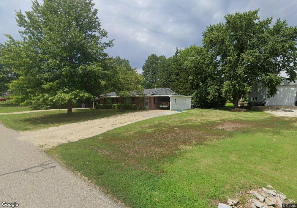
3000 Wayne Dr Manhattan, KS 66502
West Campus NeighborhoodEstimated Value: $164,000 - $293,000
4
Beds
2
Baths
1,863
Sq Ft
$132/Sq Ft
Est. Value
About This Home
This home is located at 3000 Wayne Dr, Manhattan, KS 66502 and is currently estimated at $246,288, approximately $132 per square foot. 3000 Wayne Dr is a home located in Riley County with nearby schools including Marlatt Elementary School, Susan B. Anthony Middle School, and Manhattan High School.
Ownership History
Date
Name
Owned For
Owner Type
Purchase Details
Closed on
May 30, 2020
Sold by
Mcclure Summer A and Mcclure Lincoln S
Bought by
Mcclure Summer A and Mcclure Lincoln S
Current Estimated Value
Home Financials for this Owner
Home Financials are based on the most recent Mortgage that was taken out on this home.
Original Mortgage
$113,000
Outstanding Balance
$79,438
Interest Rate
3.2%
Mortgage Type
New Conventional
Estimated Equity
$166,850
Create a Home Valuation Report for This Property
The Home Valuation Report is an in-depth analysis detailing your home's value as well as a comparison with similar homes in the area
Home Values in the Area
Average Home Value in this Area
Purchase History
| Date | Buyer | Sale Price | Title Company |
|---|---|---|---|
| Mcclure Summer A | $150,290 | -- |
Source: Public Records
Mortgage History
| Date | Status | Borrower | Loan Amount |
|---|---|---|---|
| Open | Mcclure Summer A | $113,000 |
Source: Public Records
Tax History Compared to Growth
Tax History
| Year | Tax Paid | Tax Assessment Tax Assessment Total Assessment is a certain percentage of the fair market value that is determined by local assessors to be the total taxable value of land and additions on the property. | Land | Improvement |
|---|---|---|---|---|
| 2025 | $3,846 | $27,641 | $4,555 | $23,086 |
| 2024 | $3,846 | $26,325 | $3,701 | $22,624 |
| 2023 | $3,824 | $26,071 | $4,230 | $21,841 |
| 2022 | $3,646 | $23,892 | $4,198 | $19,694 |
| 2021 | $3,925 | $21,719 | $3,927 | $17,792 |
| 2020 | $4,126 | $21,068 | $3,390 | $17,678 |
| 2019 | $3,925 | $19,617 | $3,370 | $16,247 |
| 2018 | $3,798 | $19,815 | $3,370 | $16,445 |
| 2017 | $3,728 | $19,815 | $3,370 | $16,445 |
| 2016 | $3,599 | $19,075 | $3,350 | $15,725 |
| 2014 | -- | $0 | $0 | $0 |
Source: Public Records
Map
Nearby Homes
- 2919 Marlatt Ave
- 2942 Marlatt Ave
- 3220 Gary Ave
- 3111 Harahey Ridge
- 2904 Tatarrax Dr
- 3360 Effingham St
- 3436 Westbaker St
- 2129 Tamarron Terrace
- 3621 Hawthorne Woods Terrace
- 3709 Hawthorne Woods Terrace
- 2020 Browning Ave
- 2018 Browning Ave
- 3450 Stonehenge Dr
- 2101 Abbott Cir
- 1820 Cassell Rd
- 1828 Cassell Rd
- 2411 Woodway Dr Unit A
- 2411 Woodway Dr Unit K
- 2847 Oregon Ln
- 1820 Denholm Dr
- 3004 Wayne Dr
- 3001 Sunnyside Dr
- 3009 Sunnyside Dr
- 3008 Wayne Dr
- 2917 Wayne Dr
- 3009 Wayne Dr
- 2917 Sunnyside Dr
- 2914 Wayne Dr
- 3013 Sunnyside Dr
- 2913 Sunnyside Dr
- 2915 Wayne Dr
- 3011 Wayne Dr
- 3004 Pecanwood Dr
- 3000 Pecanwood Dr
- 3008 Pecanwood Dr
- 3000 Sunnyside Dr
- 3012 Pecanwood Dr
- 2916 Sunnyside Dr
- 3017 Sunnyside Dr